2.0 Regional Geologic and Tectonic Setting
2.1 Location
American Samoa is an unincorporated territory of the United States located in the South Pacific Ocean, southeast of the sovereign state of Samoa (formerly known as Western Samoa). The main (largest and most populous) island is Tutuila, with the Manu'a Islands, Rose Atoll, and Swains Island also included in the territory. American Samoa is part of the Samoan Islands chain, located west of the Cook Islands, north of Tonga.
The Independent State of Samoa (formerly known as Western Samoa and German Samoa), is a country governing the western part of the Samoan Islands in the South Pacific Ocean. The two main islands of Samoa are Upolu and Savai'i.
Wright (2002) has studied the seafloor of American Samoa prior to the tsunami has provided a substantial amount of GIS bathymetric and coastal terrain data, which can be downloaded at: http://dusk.geo.orst.edu/djl/samoa/#3d
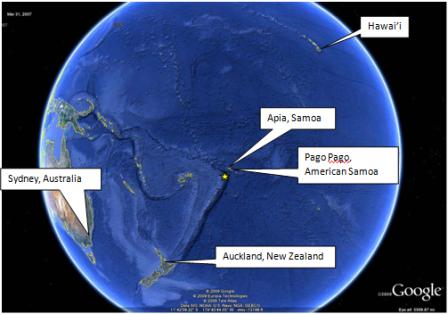
Figure 1. World View of Samoa and American Samoa (courtesy of Google Earth)
2.2 Tectonic Setting
The earthquake occurred at 15.509 S., 172.034 W, at 17:48:10 UTC (6:48 am Local). The Mw 8.0 earthquake was located at a depth of 18 km. Other valuable earthquake source parameters (from Jascha Polet, personal communication)
- Mo = 1.17x10^11 Nm;
- Strike = 138.7 degrees,
- Dip = 40 degrees,
- Rake = -90 degrees,
- Fault length =125 km;
- Fault width = 40 km;
- Centroid depth = 15 km; and
- Average fault slip = 10 m
The broad-scale tectonics of the Tonga region are dominated by the relative convergence of the Pacific and Australia plates, with the Pacific plate subducting westward beneath the Australia plate at the Tonga trench. At the latitude of the earthquake of September 29, 2009, the Pacific plate moves westward with respect to the interior of the Australia plate at a velocity of about 86 mm/year. The earthquake occurred near the northern end of a 3,000 km long segment of the Pacific/Australia plate boundary that trends north-northeast; farther north of the earthquake’s source region, the plate boundary trends northwest and then west. The eastern edge of the broad Australia plate may be viewed as a collection of small plates or microplates that move with respect to each other and with respect to the Pacific plate and the Australia plate interior.
On the basis of currently available location and fault mechanism information, the U.S. GEOLOGICAL SURVEY has inferred that the September 29 earthquake occurred as a normal fault rupture on or near the outer rise of the subducting Pacific plate.
The broad-scale Australia/Pacific plate boundary is one of the most active earthquake regions in the world. Earthquakes occur on the thrust-fault boundary between the Australia and Pacific plates, within the Pacific plate on both sides of the trench, and within and on the boundaries of the small plates that compose the eastern edge of the overall Australia plate. (U.S. GEOLOGICAL SURVEY, 2009).
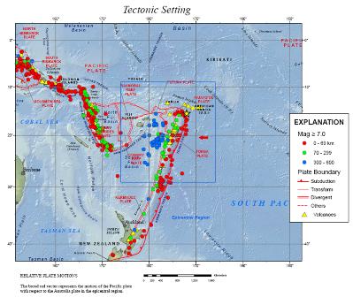
Figure 2. Tectonic Setting of the Samoa Islands Region (Courtesy U.S. GEOLOGICAL SURVEY Earthquake Information Center, 2 October 2009)
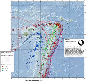
Figure 3. Seismicity for 2009 for the Samoa Islands Region with Earthquake of 29 September 2009. (Courtesy U.S. GEOLOGICAL SURVEY Earthquake Information Center, 2 October 2009)
2.3 Historic Seismicity
The earthquake occurred in a region of high seismicity. As seen in Table 1, since the early 1900’s, 14 large earthquakes have shaken the region.
Table 1. Seismicity for Samoa Islands Region 1900 to present, Mw=>7.5. (courtesy of U.S. GEOLOGICAL SURVEY)
Year |
Month |
Day |
Time |
Lat |
Long |
Magnitude |
1903 |
01 |
04 |
0507 |
-20.000 |
-175.000 |
8.0 |
1913 |
06 |
26 |
0457 |
-20.000 |
-174.000 |
7.7 |
1917 |
06 |
26 |
0549 |
-15.500 |
-173.000 |
8.5 |
1919 |
01 |
01 |
0300 |
-19.971 |
-177.914 |
7.7 |
1919 |
04 |
30 |
0717 |
-19.823 |
-172.215 |
8.2 |
1937 |
04 |
16 |
0301 |
-20.768 |
-177.144 |
7.5 |
1948 |
09 |
08 |
1509 |
-21.000 |
-174.000 |
8.0 |
1950 |
12 |
14 |
0152 |
-19.250 |
-175.750 |
7.5 |
1957 |
04 |
14 |
1918 |
-15.403 |
-173.129 |
7.5 |
1962 |
05 |
21 |
2115 |
-19.962 |
-177.272 |
7.5 |
1975 |
12 |
26 |
1556 |
-16.241 |
-172.364 |
7.7 |
1981 |
09 |
01 |
0929 |
-15.112 |
-173.019 |
7.5 |
2006 |
05 |
03 |
1526 |
-20.187 |
-174.123 |
8.0 |
2009 |
09 |
29 |
0648 |
-15.560 |
-172.070 |
8.0 |
2.4 Tsunami Aspects
The fault parameters specified in Section 2.2 were used to calculate the tsunami wave field throughout the region. The maximum wave heights for the Samoan Islands are shown in Figure 4 through Figure 9. Figure 10 shows a comparison between the tide gauge recordings at Pago Pago and Apia and the tsunami waveform calculated using the earthquake source model, showing good agreement. The recorded tsunami wave heights (peak-to-trough) were:
- 314 cm at Pago Pago, American Samoa;
- 140 cm at Apia, Samoa;
- 47 cm at Rarotonga and
- 8 cm at Penrhyn, Cook Islands;
- 14 cm at Nuku`alofa, Tonga;
- 11 cm at Papeete, French Polynesia.
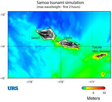
Figure 4. Maximum wave heights in Samoa and American Samoa
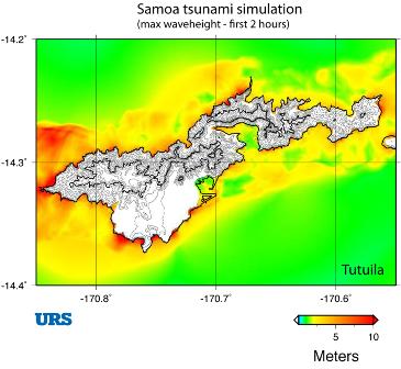
Figure 5. Detailed map of maximum wave heights in American Samoa (Tutuila)
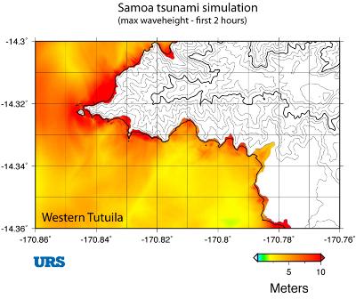
Figure 6. Detailed map of maximum wave heights in western Tutuila, American Samoa
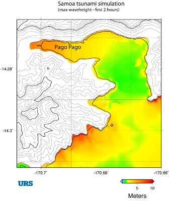
Figure 7. Detailed map of maximum wave heights around Pago Pago, American Samoa
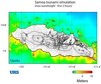
Figure 8. Detailed map of maximum wave heights for Upolu Island, Samoa
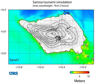
Figure 9. Detailed map of maximum wave heights for Savai'i Island, Samoa
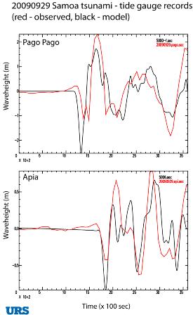
Figure 10. Tide gauge recordings (red) and model simulations (black) at Pago Pago (American Samoa), top, and Apia Upolu Island, Samoa, bottom. The data have been low-pass filtered to remove the tidal component. The Apia data have been shifted in time by 4 minutes. |