| |
|
|
|
|
1.0 Introduction
1.1 Introduction
The M7.2 mainshock of the Sierra El Mayor - Cucapah earthquake occurred at 3:40 pm local time on April 4, 2010, which was Easter Sunday. The mainshock was followed by a sequence of aftershocks that were felt during the reconnaissance effort and continue to the present. The mainshock had an estimated focal depth of 10 km (USGS, 2010) and struck in the El Mayor and Cucapah mountains to the southwest of Mexicali, Baja California, Mexico. The epicenter was located at 32.237°N, 115.083°W (USGS, 2010). The earthquake was felt throughout northern Baja California and southern California, and caused damage in a region from the Sea of Cortez in the south to the Salton Sea in the north. This earthquake is the largest to strike this area since 1892.
The USGS seismic intensity was IX near the fault rupture, and VIII in Mexicali, which is the nearest densely-populated area. The largest peak ground acceleration of 0.58g was recorded at McCabe School about 5 km southwest of El Centro, CA. The earthquake ruptured the surface for as much as 140 km from the northern tip of the Sea of Cortez northwestward to nearly the international border, with strike-slip, normal, and oblique displacements observed. The earthquake resulted in two fatalities and hundreds of injuries. Damage occurred to irrigation systems, water treatment facilities, buildings, bridges, earth dams, and roadways. Liquefaction and ground subsidence was widespread in the Mexicali Valley, and left wheat and hay fields submerged under water and destroyed many canals that irrigate fields in the predominantly agricultural region. The largest lasting effect of the earthquake is its impact on agricultural infrastructure (including levees and canals) in the Mexicali Valley and Imperial Valley. This damage is anticipated to cost hundreds of millions of dollars to repair (Personal Communication with Robert Anderson, California Seismic Safety Commission), and the earthquake has provided important lessons regarding water infrastructure in seismically active regions.
The GEER reconnaissance effort occurred in multiple phases with many participants, and covered the region shown in Fig. 1-1. Effort among the GEER participants in summarized in Table 1-1. The GEER team coordinated their activities with those of the EERI team, which focused principally on structural damage and lifelines performance (Meneses et al. 2010). The GEER reconnaissance teams' main goal was to quantify the spatial extent and amplitude of surface fault rupture, ground failure, liquefaction, landslides, and geotechnical-related damage to bridges, piers, buildings, lifeline systems and critical structures. Each of the teams was equipped with digital cameras, maps, personal computers, and GPS units for recording track logs and site locations. Track logs and images were uploaded to the GEER ftp repository and were integrated into a single Google Earth KMZ file (Fig. 1-1). The epicenter, shaking intensity map, ground motion recording stations, and aftershocks were also superposed on the KMZ file for reference. The KMZ file was useful for identifying which areas had been well-covered and which areas had not, and was critical for guiding our reconnaissance efforts.
Table 1-1. Time frame and focus of GEER reconnaissance teams.

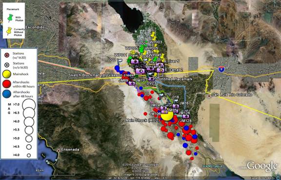
Figure 1-1. Screen shot of Google Earth kmz file showing area covered by the GEER reconnaissance effort.
This reconnaissance report has been organized into chapters that describe the geological and seismological setting (Chapter 2), surface fault rupture (Chapter 3), recorded earthquake ground motions (Chapter 4), liquefaction (Chapter 5), and performance of canals, levees and earthen dams (Chapter 6).
This earthquake reconnaissance effort was made possible by funding from the U.S. National Science Foundation, cost sharing by the U.S. Geological Survey, and California Geological Survey and volunteer work by the team participants. This material is based upon work supported by the National Science Foundation under Grant No. CMS-032914. Any opinions, findings, conclusions or recommendations expressed in this material are those of the authors and do not necessarily reflect the views of the sponsoring organizations.
References
USGS (2010). "Magnitude 7.2 - Baja California, Mexico, 2010 April 04 22:40:42 UTC." http://earthquake.usgs.gov/earthquakes/eqinthenews/2010/ci14607652/.
Meneses et al. (2010). "EERI Preliminary Reconnaissance Report on the 2010, M 7.2 El Mayor-Cucapah Earthquake." Earthquake Engineering Research Institute.
|
|