| |
|
|
|
|
3.0 Surface Fault Rupture Associated with the El Mayor-Cucapah Earthquake of April 4, 2010
3.1 Rupture Overview
Surface rupture associated with the April 4, 2010 El Mayor-Cucapah earthquake extends for as much as 120 km from the northern tip of the Gulf of California northwestward to nearly the international border, with breakage on several faults (Figure 3-1). The rupture is discontinuous, with a discrete zone of no rupture for about 10 km between the Pescadores and Borrego faults. Towards the northern third of the rupture, breaks occur across a several kilometer wide zone and involve both previously recognized and unrecognized faults.
Displacements involved both normal and strike-slip senses of motion, and although the strike-slip displacements were generally larger, a normal component persists for much of the length of the rupture. The system of faults involved in the earthquake include low-angle detachments, at least one of which was activated in this earthquake.
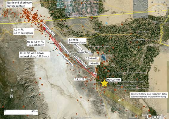
Figure 3-1. Simplified map of the rupture associated with the April 4th, 2010 El Mayor-Cucapah earthquake. Note that coherent rupture on discrete faults in the delta region is not shown, as extensive liquefaction may have erased their evidence.
The locally shallow dip of the detachment in part explains the distributed style of strike-slip deformation in the hanging wall block that we documented at the surface, and this is especially the case in the northern parts of the rupture.
In this report, we first discuss the search for rupture in the delta region, and the observations for the primary ruptures along the Pescadores and the Borrego faults, the two faults that express the largest displacements. We then discuss the complex ruptures in the north, including the secondary faulting along the Laguna Salada fault. We briefly discuss what others have reported as triggered slip on faults located north of the border. We conclude with a brief discussion on how this rupture illustrates the complexity that can develop when a rupture propagates through a network of high- and-low angle faults that accommodate the three-dimensional strain of transtensional plate margin shearing.
3.2 The Delta Region
The southern part of the rupture consists of a zone of distributed fracturing and liquefaction that cuts across the Colorado River delta. Individual fractures vary widely in orientation and have relatively short strike lengths of the order of hundreds of meters (Figure 3-2). The zone itself may be related to faults that bound the eastern margin of the Sierra El Mayor, but field relationships are unclear, and the zone of more intense fracturing diverges significantly from the mountain front toward the south.

Figure 3-2. Possible faulting in the delta region (interpreted by Ken Hudnut, USGS). Note the extensive liquefaction, make recognition of faults difficult.
That rupture occurred in the delta region is clear from the SPOT image differencing and analysis of InSAR imagery (Fielding et al., 2010; Sandwell et al., 2010; Wei et al., 2010), and the epicenter of the mainshock was located south of the Sierra Cucapah in the delta region east of the Sierra Mayor. Nevertheless, identification of a continuous ground rupture, as is described below for the rupture farther north, has been elusive in the thick alluvial fill of the Colorado River delta.
3.3 The Pescadores Rupture
The Pescadores fault ruptured from the at least as far south as where the fault enters the sediments of the delta northward to the central part of the Sierra Cucapah (Figure 3-1), a distance of about 21 km. For the southern 3.5 km or so, the Pescadores rupture follows two discrete faults southward to the delta sediments, with maximum displacements of about 1.6 m for the eastern splay and 0.7 m for the western splay (Figures 3-3 and 3-4). Where these faults enter the delta sediments, displacement on each is down to about 5 cm, so it is clear that some surface deformation continues into the soft sediments of the delta fill. However, based on the rate of drop off in displacement, we doubt that discrete slip on this zone extends for much more than an additional kilometer or two.
These two splays merge northward along the primary mapped trace of the Pescadores fault (Gastil et al., 1971), with the displacement increasing to maximum values in the 2.5-4 m range for strike slip (Figures 3-5 and 3-6). The sense of vertical separation varies along the central part of the Pescadores rupture, consistent with the dominant strike-slip character of this part of the rupture, becoming east side down to the north (Figure 3-7).

Figure 3-3. Offset road berm along the east fork of the southern Pescadores rupture. Note that the apparent separation is less than the actual displacement because the rupture crosses the road at an oblique angle. Maximum displacement on the east fork is recorded at about 1.6 m right-lateral, with no consistent or significant vertical displacement. (Photo by T. Rockwell).
For the central and southern Pescadores fault, the sense of slip is mostly strike-slip, although the western fork of the southernmost part of the rupture expressed some east-side-down displacement along with the dominant strike-slip (Figure 3-4).
An interesting feature discovered along this part of the rupture is an active steam vent (Figure 3-8). We do not know if this vent was active prior to the earthquake, but we could find no local people who knew of this feature, so it is quite possibly a consequence of the earthquake.

Figure 3-4. Offset channel edge along the western splay of the southern Pescadores rupture. Maximum displacement in this area was measured at about 70 cm. (Photo by T. Rockwell)

Figure 3-5. Lateral slip dominates along the central part of the Pescadores rupture. Slip in this photo is at least 220 cm right-lateral and 90 cm down to the east vertical, based on offset of the channel thalweg. (Photo by J. Fletcher)

Figure 3-6. Measurement of maximum slip along the Pescadores rupture. Displacement is 430 cm of mostly right-lateral slip marked by an offset bush. Striae on the fault surface are parallel to the tape measure.

Figure 3-7. Central part of the Pescadores rupture, looking to the southeast (Photo by John Galetzka). Note the small west side up component of slip on the antithetic fault, and the much larger east side down along the main fault at the right of the photo.

Figure 3-8. Steam vent discovered along the central part of the Pescadores rupture. (Photo by J. Fletcher).
Northward along the northern third of the Pescadores section of rupture, a strong down-to-the-east component of slip emerges (Figures 3-7 and 3-9), before the rupture steps left (west) to the Borrego fault. At the northern end of the Pescadores rupture, slip appears to be dominantly vertical, with east side down. As the southern Borrego rupture, as discussed below, is also east-side down, this observation suggests that the rupture at depth may have followed a low-angle detachment fault, transferring slip to the west.

Figure 3-9. Down-to-the-east scarp along the north-central Pescadores rupture with oblique slip. Maximum vertical displacement along the northern Pescadores rupture is about 1.5 m. (Photo by J. Fletcher)
3.4 Borrego Fault Rupture
Only the northern half of the Borrego fault ruptured in the earthquake (Figures 3-1 and 3-11). Between the Pescadores and Borrego ruptures, there is about 10 km of unruptured zone, at least in terms of surface slip (Figure 3-1). Nevertheless, the area between ruptures is extensively shattered, suggesting that rupture may have propagated beneath this section at depth, perhaps utilizing a low-angle detachment surface to connect from the Pescadores to the Borrego surface faults. While searching for offset in the field for this section of the fault, we noted cobbles that had been thrown in the air, landing several cms from the divot in which they originated (Figure 3-12). Many of these clearly required the stones to actually be airborne for a short distance, as there was no evidence that they scooted across the sediment, suggesting to us that vertical accelerations may have locally exceeded 1g.
The part of the Borrego fault involved in the earthquake sustained a prominent down-to-the-east sense of vertical slip, along with the dominant strike-slip component (Figures 3-1, 3-11 and 3-13 through 3-15). Within Borrego Valley, along which about 9 km of the Borrego fault sustained rupture, maximum right lateral displacements of 3.1 m were recorded (Figures 3-1 and 3-13). In this same area, maximum down-to-the-east vertical displacements varied from less then a meter to over 2 m (Figure 3-12).

Figure 3-11. Map of the rupture in Borrego Valley, and along the Laguna Salada range front. Selected displacements shown are representative. Different colors represent different phases of mapping, with the blue being very detailed mapping whereas the purple is more generalized.

Figure 3-12. Photograph of cobbles that were displaced during the earthquake. These occur as a band along the Borrego and Pescadores faults between the two ruptures. (Photo by T. Rockwell)

Figure 3-13. Mosaic of a panorama sequence, looking west, showing the rupture in Borrego Valley (photo by T. Rockwell, mosaic work by K. Mueller). Note the long-term lateral offsets of the large channel and the oblique nature of the 2010 rupture.

Figure 3-14. Oblique offset of an incised channel. Slip in this area reached over 3 m horizontal and over 1.5 m vertical, with maximum vertical over 2 m.

Figure 3-15. East-facing scarp along the Borrego fault in Borrego Valley. John Fletcher (for scale) is nearly 1.9 m tall, showing that locally, the vertical component exceeded 2 m. (Photo by T. Rockwell)
At the north end of Borrego Valley, the strike-slip on the system steps left across the range-fronting hills to the Laguna Salada fault (Figure 3-11), and farther north, to the Paso Superior fault Figure 3-1). South of this step in strike-slip, the northern half of the range-front Laguna Salada fault ruptured with minor dip slip (Figure 3-16).

Figure 3-16. 2010 rupture along the northern front range of the 1892 Laguna Salada fault rupture. (Photo by T. Rockwell)
3.5 Laguna Salada Ruptures, and North to Paso Superior
We measured 10-30 cm of dip slip along the northern half of the range-front fault that ruptured in a large Mw7.2 earthquake in 1892 (Mueller and Rockwell, 1995)(Figure 3-16). In the 1892 earthquake, as much as 4 m of right lateral displacement and 3-3.5 m of down-to-the-west dip displacement is inferred from the geomorphology (Mueller and Rockwell, 1991; 1995), and the 2010 rupture is superposed on this much larger scarp. Also of note, the 2010 rupture displayed no evidence for a strike-slip component along the range front fault, in contrast to the oblique rupture of the 1892 rupture. As the estimated repeat time for 1892-type events was determined to be about 1-2 ka, it is somewhat surprising that the central Laguna Salada fault re-ruptured with the 2010 earthquake. It is possible that the displacements along range front fault are the result of triggered slip and collapse of the basin.
Farther north, the 2010 rupture along the Laguna Salada fault continues for an additional 3 km, where the it bends north and steps to join the Paso Superior fault. In our mapping, we identify older scarps in young alluvium that almost certainly represent rupture in the 1892 earthquake (Figure 3-17), which is farther north than previously reported by Mueller and Rockwell (1995).

Figure 3-17. Rupture from 2010 along a pre-existing scarp in late Holocene alluvium. The older scarp is interpreted to be associated with the 1892 rupture, as it is along strike and recorded in alluvium that is of similar age (Q2 of Mueller and Rockwell, 1995) to the alluvium along the front of the Sierra Cucapahs that has experienced only the 1892 rupture. (Photo by T. Rockwell)
Within 2-3 km northward of the northern end of the front range, the sense of vertical slip along the normal fault rupture reverse from west side down to east side down (Figure 3-18), with scarp heights that locally exceed half a meter. The primary western fault maintains primarily a dip slip sense of motion, in spite of this change in the direction of vertical slip, but another, previously unrecognized fault between the Borrego and Laguna Salada faults apparently transfers significant strike-slip from the Borrego fault to the frontal fault system (Figures 3-11 and 3-19). We measured as much as 1.6 m of right-lateral strike-slip on this previously unrecognized and unnamed fault.

Figure 3-18 East-facing scarp along the northward continuation of the Laguna Salada fault. View is to the west, with the Sierra Juarez in the background.
Farther north, the east-side-down sense of slip continues as the rupture steps and bends east from the Laguna Salada fault and connects to the Paso Superior fault (Fletcher et al., 2010), another previously unmapped fault, as discussed earlier in this report.

Figure 3-19. Previously unrecognized fault (foreground) with substantial right-lateral strike-slip. In the background, note the dip slip northern continuation of the Laguna Salada fault. Photo looks southwest, and is near the juncture of these two faults.
3. 6 Paso Superior Ruptures
As shown in Figure 3-1, the rupture crosses the range front and diverges from the Laguna Salada fault near Paso Inferior, to connect to the Paso Superior fault, a low-angle oblique detachment fault. The low angle nature of this fault is clearly exposed in the road cut of Mexican highway 2 (Figure 3-20), where Palm Spring Formation is in fault contact with basement rock. It is the low-angle nature of the fault in the near surface that has caused the rupture to spread out, with slip partitioned in some areas between the high-angle primary fault and scarp, and the distributed strike-slip faulting in the hanging wall (Figures 3-21 and 3-22). This is particularly true in the area of the highway, and without the highway and fence lines as reference frames, it is likely that we would have missed the majority of strike-slip in this area. Consequently, it is possible that we under-estimated the strike-slip component for other areas along the rupture to the south, and specifically along the Borrego fault in Borrego Valley.

Figure 3-20. Low-angle detachment fault exposed in the north cut of Highway 2. The rupture is just to the left of this photo, and this is apparently the fault along which rupture occurred in the near surface.

Figure 3-21. Rupture crossing Old Highway 2, just north of the modern highway. Note that all of the lateral slip is carried by distributed faults in the hanging wall. (Photo by T. Rockwell)
North of Highway 2, the rupture continues for about 5 km. Towards the northernmost 1-2 km, the rupture spreads into several smaller breaks and mostly dies where the bedrock passes beneath the Palm Spring Formation sediments at a detachment fault contact. North of this contact, the rupture is apparently mostly blind.

Figure 3-22.
View looking south across the rupture between the old highway and the new highway, located in the road-cut in the fore ground. The rupture exceeded 30 m in width in this area, and nearly all strike-slip was on these secondary, hanging-wall faults. (Photo by T. Rockwell)
3.7 Secondary Rupture and Triggered Slip North and South of the Border
Several minor breaks were triggered on other major and minor faults, both north and south of the border (Treiman et al., 2010; Suarez-Vidal et al., 2010, Glowacka et al., 2010). Glowacka et al. (2010) report 2-4 cm of dip slip and 1-1.5 cm right-lateral strike slip on the Saltillo fault (southern end of the Imperial fault zone), up to 6 cm of vertical slip on the Cerro Prieto fault, and up to 30 cm of vertical slip on the Morelia fault, which lies between the Cerro Prieto and Imperial faults. To the north, Treiman et al. (2010) report triggered slip on the San Andreas, Imperial, Coyote Creek and Superstition Hills fault, all of which typically experience triggered slip in large nearby earthquakes. They also document triggered slip on the Brawley and Weinert faults (~1 cm and 0.5 cm, respectively), and more notably related to this earthquake, 1-3.5 cm on the northernmost few kms of the Laguna Salada fault, as well as some left-lateral displacements of up to a few cms on northeast striking faults in the Yuha Desert.
3.8 Discussion
The rupture associate with the El Mayor-Cucapah earthquake is notable because of its complexity, and the implications for strain accommodation in a transtensional plate margin setting. The complexity issue relates to the observation that the northern half of the rupture propagated for 55 km through an imbricate stack of east-dipping faults in the Sierra Cucapah, and part of the complexity of the rupture can be attributed to interaction with these detachment faults that allowed the rupture to expand in the near surface. This entire region has undergone substantial extension during the Pliocene and into the Quaternary, and this earthquake demonstrates that some extension persists. The primary rupture may, in fact, be on a steeply dipping oblique normal fault at depth, which flattens towards the surface, resulting in the spreading of the surface rupture and local partitioning of the strike-slip and dip slip components. Considerable work lies ahead in unraveling the deep structure associated with seismic slip, and whether the displacement at depth actually occurred along a seismically active detachment surface.
Additionally the northern Laguna Salada fault (1892 segment) re-broke with minor (10-30 cm) dip slip along a segment that is adjacent to the primary Borrego rupture, which has major implications for seismic hazard studies. Specifically, there is commonly a question on the likelihood that a fault that has recently ruptured in a large earthquake will break again when a nearby fault ruptures. The 2010 earthquake suggests that recently-ruptured faults may move again “before their time” with some fraction of the typical slip in response to rupture of nearby or kinematically related faults, possibly to accommodate local stresses from the more recent event.
In general, a fault with a long return period such as the 1-2 ka timeframe for the Laguna Salada fault is considered to have a relatively low rupture potential when it ruptured in the very near past, in this case in 1892. The 1892 rupture was much larger and experience as much as 5 m of oblique slip. Nevertheless, the 2010 earthquake produced 10-30 cm of dip slip along part of this historical rupture, and could have caused significant damage had structures been built across it. It is also important to note that such a small displacement superposed on the 5 m oblique slip of 1892 is not likely to be recognized in paleoseismic studies, so such events are likely to be transparent if they have occurred in the past.
Finally, another aspect of seismic hazard relates to prediction of the distribution of near-surface displacement. In the case of the northern Borrego and Paso Superior faults, much of the strike-slip will be erased quickly in the geomorphology because it is distributed across many minor hanging wall faults with little or no vertical component of slip. Trenching across such a fault would undoubtedly have identified the main dip-slip fault as the primary fault, and 3-dimensional trenching across the main fault would have resolved principally dip-slip. In the case of the 2010 earthquake, the principal sense of slip is strike-slip, but this would likely be missed along much of the northern half of the rupture, once the hanging wall faults that carry the strike-slip are erased by erosion. It is thus important to consider the structural environment in which such studies are undertaken, and to consider the possibility of distributed slip in regions of past and present extensional and transtensional faulting.
References Cited
Fielding, E., Wei, S., Leprince, S., Sladen, A., Simons, M., Avouac, J.P., Lohman, R., Briggs, R., Hudnut, K., Helmberger, D., and Akciz, S., 2010, InSAR and subpixel correlation pixel tracking measurements combined with bodywave analysis for finite fault modeling of the 2010 El Mayor-Cucapah earthquake. Abstract for the Cordilleran section of the Geol. Society of America, Anaheim, May 27-29, 2010.
Gastil, R.G., Phillips, R.P., and Allison, E.C., 1971, Reconnaissance geologic map of the state of Baja California. Geological Society of America Memoir 140, 170 p.
Glowacka, E., Vazquez, R., Sarychikhina, O., Nava, F. A., Farfan, F., Diaz de Cossio Batani, G., 2010, Deformations triggered by the M=7.2, April 04, 2010, El Mayor earthquake on faults in the Mexicali Valley. Abstract for the Cordilleran section of the Geological Society of America, Anaheim, May 27-29, 2010.
Mueller, Karl J. and Rockwell, Thomas K., 1995, Late Quaternary activity of the Laguna Salada fault in northern Baja California, Mexico: Geological Society of America Bulletin, v. 107, no. 1, pp. 8-18.
Mueller, K.J., and Rockwell, T.K., l991, Late Quaternary structural evolution of the western margin of the Sierra de los Cucapas, Baja California, Mexico: American Association of Petroleum Geologists Memoir 47, ch. 14, p. 249-260.
Sandwell, D., Wei, M., Gonzales, J., Gonzales, A., Lipovski, B., Funning, G., Fialko, Y., Mellors, R., Agnew, D., Peterson, R., and Ma, Z., 2010, InSAR and GPS Measurements of Crustal Deformation from the El Major Earthquake: Liquefaction and Triggered Slip. Abstract for the Cordilleran section of the Geological Society of America, Anaheim, May 27-29, 2010.
Suarez-Vidal, F., Mendoza-Borunda, R., Vazquez, S., and Mendoza, L., 2010, Preliminary Report of the Geological Effects and Damage Distribution of the April 4th, 2010 Cucapah-El Mayor Earthquake, Mexicali Valley, BC, Mexico. Abstract for the Cordilleran section of the Geological Society of America, Anaheim, May 27-29, 2010.
Treiman, J., Rymer, M.J., Kendrick, K.J., Lienkaemper, J.J., Weldon, R.J., Hernandez, J.L., Irvine, P.J., Knepprath, N., Olson, B.P.E., and Sickler, R.R., 2010, Triggered Slip in Southern California as a result of the April 5, 2010 El Mayor-Cucapah Earthquake. Abstract for the Cordilleran section of the Geological Society of America, Anaheim, May 27-29, 2010.
Wei, S., Sladen, A., Leprince, S., Avouac, J-P., Fielding, E., Chu, R., Simons, M., Helmberger, D.V., Hauksson, E., Lohman, R., Briggs, R., Hudnut K., and Akciz, S., 2010, Joint inversion of geodetic and seismic slip models for the April 04, 2010 El Mayor-Cucapah Earthquake. Abstract for the Cordilleran section of the Geological Society of America, Anaheim, May 27-29, 2010.
|
|