Preliminary Geotechnical Earthquake Engineering Observations of the September 21, 1999, Ji-Ji, Taiwan Earthquake
Initial Reconnaissance Team
Acknowledgments
Summary
Location of Casualties
and Damages
Tectonics and Strong Motions
Initial
Reconnaissance Team
This preliminary report summarizes the initial observations of the advanced
party of the Taiwan/US geotechnical reconnaissance team sponsored by the
US National Science Foundation and various organizations from Taiwan. This
report covers the initial reconnaissance efforts between September 29 and
October 2, 1999. Ongoing work will lead to more comprehensive reports in
the future. The members of the advanced party are:
-
Norm Abrahamson, Pacific Gas and Electric Company
-
Jean-Pierre Bardet, University of Southern California, Los Angeles
-
Jonathan Bray, University of California, Berkeley
-
Yin-Wen Chan, National Taiwan University, Taipei
-
C.-Y. Chang, Geomatrix
-
Yung-Show Fang, National Chiao Tung University, Hsinchu
-
Cheng-Hsing Chen, National Taiwan University, Taipei
-
Les Harder, California
-
An-Bin Huang, National Chiao Tung University, Hsinchu
-
Steve Huang, KCE Matrix, Glendale
-
Woody Ju, University of California, Los Angeles
-
Mr. Ming-Jeh Kuo, Taichung Harbor Bureau, Taichung
-
Steve Kramer, University of Washington, Seattle
-
Wei Feng Lee, University of Washington
-
Meei-Ling Lin, National Taiwan University, Taipei
-
Chin-Hsiung Loh, National Center for Research in Earthquake Engineering,
Taipei
-
Chang-Yu Ou, National Taiwan University of Science and Technology
-
Jerry Jia-Dwzen Shen, SUNY Buffalo
-
Jonathan Stewart, University of California, Los Angeles
-
Joseph I. Sun, Geolabs, Inc.
-
Donald Wells, Geomatrix
-
Robert Wright, Geomatrix
Organization
of Preliminary Reports
The preliminary reconnaissance report has been subdivided in smaller
separate reports for an easier posting on the Internet. The reports cover
the following subjects:
-
Introduction (this report)
-
Aerial surveys of damaged areas
-
Bridges
-
Harbor of Taichung
-
Yuanlin
-
Fengyuan
-
Chao-lin landslide
-
Southern areas
Additional reports will be gradually added to the list above as they become
available from the various reconnaissance teams. Please report to bardet@usc.edu
any errors and inaccuracies which you may discover.
Acknowledgments
We would like to express all our thanks to our Taiwanese and American
colleagues who helped us in our reconnaissance effort and to express our
sincere sympathy to the victims of this natural disaster. We acknowledged
the financial support of the US National Science Foundation and of various
organizations from Taiwan. Some researchers were supported by the Pacific
Earthquake Engineering Research Center (PEER).
Summary
On September 21, 1999 at 1:47 AM (local time) a magnitude ML
7.3 earthquake struck the central part of Taiwan. This is the largest earthquake
of the twentieth century in Taiwan. On October 3, 1999, the Central National
Fire Administration (NFA) reported a death toll of 2246 and a total number
of injured of 8735. NFA also reported that there were still 38 persons
missing, 58 trapped under rubble, and 7 stranded in remote areas. On October
3, 1999, 4540 persons had been rescued. The total population of Taiwan
is 22 million. The material damage is extensive: 9909 buildings collapsed,
and 7575 were damaged. These numbers are likely to change with time. Revised
estimates can be obtained from http://www.ncree.gov.tw.
The epicenter was located at 23.85N, 120.81E (CWB) at a depth of 6.99
km (CWB). The earthquake epicenter was located at Jiji along the thrust
fault called Tamoupu-Hsuangtung. The fault rupture mechanisms and strong
motion recordings can be obtained from the National Center for Research
in Earthquake Engineering (NCREE) of the National Taiwan University in
Taipei at http://www.ncree.gov.tw
Location
of Casualties and Damages
Figures 1 and 2 display the distribution of casualties and damage per
county and municipality, which is listed in Table 1 (NCREE). Casualties
and damage are concentrated in the counties of Nantou, Taichung, Yunlin
and Changhua.
Table 1. Distribution of casualties and damage in the 1999 Jiji,
Taiwan earthquake (NFA and NCREE, 1999).
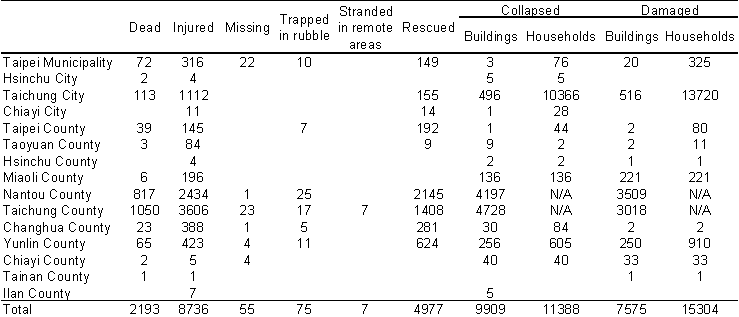
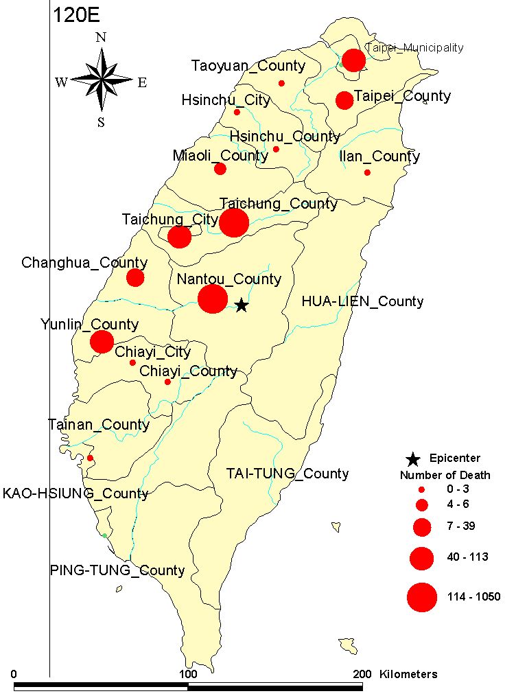
Distribution of casualties per county after the 1999 Jiji, Taiwan
earthquake (data after NFA and NCRESS, 1999.

Distribution of collapsed buildings per county after the 1999 Jiji,
Taiwan earthquake (data after NFA and NCRESS, 1999).
Tectonics
and Strong Motions
As shown in Fig. 3, Taiwan is located at the intersection of the Eurasia
plate and the Philippine Sea plate. The history of major earthquake since
1904 is summarized in Fig. 4. The 1999 Jiji, Taiwan earthquake is the largest
earthquake in Taiwan this century. As shown in Fig. 5, Taiwan has a very
dense array exceeding 600 strong motion instruments, which were triggered
by the main event. The distribution of peak ground acceleration (PGA) is
shown in Fig. 6.
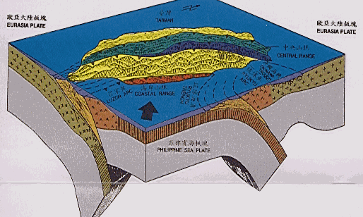
General tectonic setting of Taiwan. Taiwan is located at the intersection
of the Eurasia and Philippine Sea plates (Central Geological Survey, Ministry
of Economics Affairs, ROC, 1997).
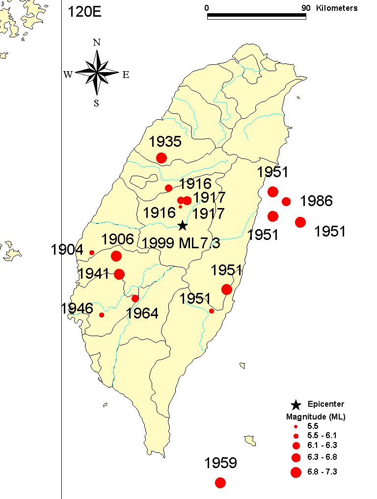
Major earthquakes in Taiwan during this century (after NCREE, 1999).
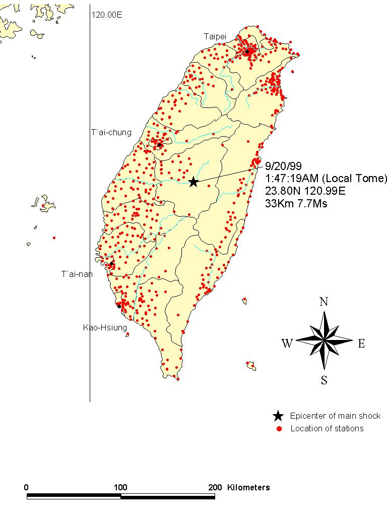
Location of strong motion stations in Taiwan (data from Central Weather
Bureau).
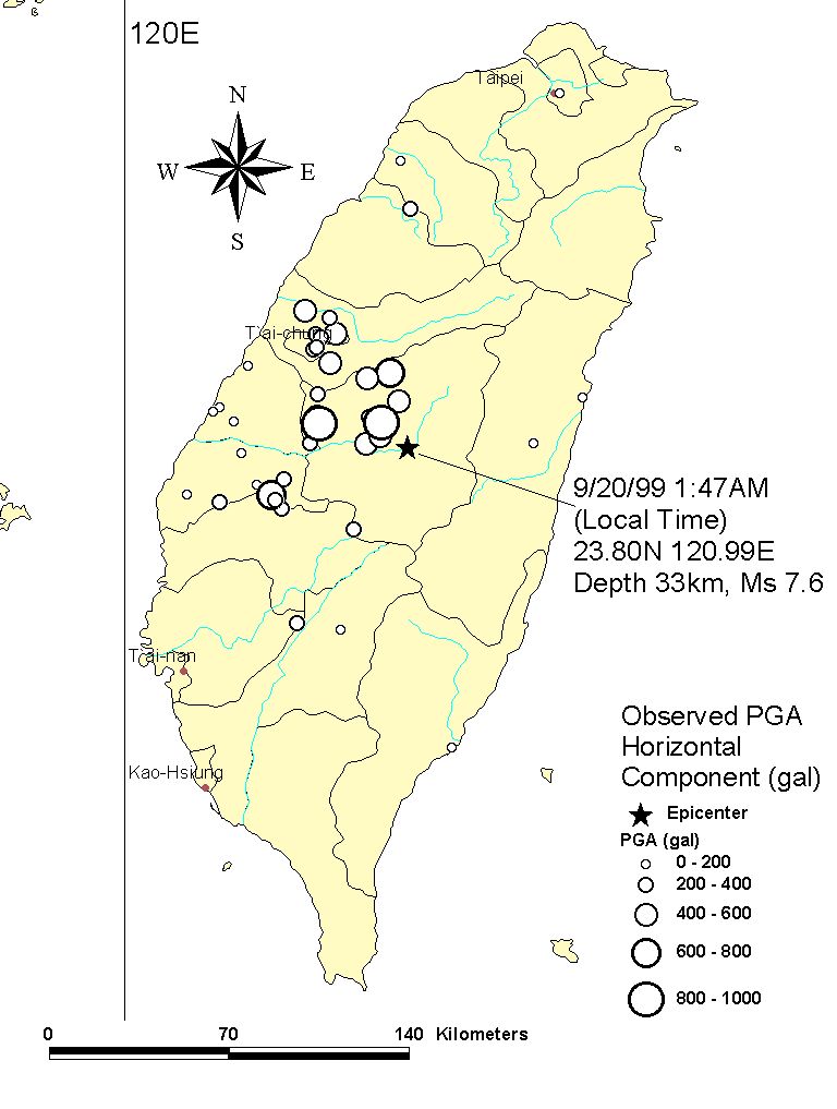
Distribution of maximum peak ground acceleration during the 1999
Jiji, Taiwan earthquake (data after NFA and NCRESS, 1999).