4.0 Damage Patterns
Site effects were investigated in the form of variable building damage intensities from one region to another having similar styles of construction. The investigations occurred at multiple scales. Within the region's largest urban center (L'Aquila), damage patterns were investigated in detail in a structure-by-structure manner. In that case, the intent was to investigate damage localization within particular geologic units or near particular geologic structures. Mapping at this scale is described in Section 4.3. In the relatively small villages outside of L'Aquila, our intent was to document general intensities of damage so that village-to-village comparisons could be made. To the extent that adjacent villages might have different underlying geologic conditions and different topographies, village-to-village damage variations could be taken as indicators of site effects. Mapping at this scale is described in Section 4.1. We have also documented damage at a number of additional villages, the results of which are presented in Section 4.2.
For both the local and relatively regional damage mapping, we used a common description of damage intensity, which is shown in Table 4.1. The marker color shown in the figure is used in figures that follow. Table 2.2 summarizes damage observations in villages.
Table 4.1. Definition of damage categories (adapted from Bray and Stewart, 2000)
Damage Level |
Description |
Marker Color |
D0 |
No damage |
|
D1 |
Cracking of non-structural elements, such as dry walls, brick or stucco external cladding |
|
D2 |
Major damage to the non-structural elements, such as collapse of a whole masonry infill wall; minor damage to load bearing elements |
|
D3 |
Significant damage to load-bearing elements, but no collapse |
|
D4 |
Partial structural collapse (individual floor or portion of building) |
|
D5 |
Full collapse |
|
4.1 Damage to Villages in the Eastern Aterno Valley
Site amplification on soil deposits is evident in the towns and villages east of L'Aquila, down the axis of the Aterno River valley. A map of the Valley can be seen in Figure 4.1 and includes the heavily damaged towns of Castelnuovo, Onna, San Gregorio, and Poggio Picenze. Other, less damaged, towns found in this valley are Monticchio, Fossa, Tussio, San Pio delle Camere, and Barisciano. Site effects are evident from relative damage between nearby villages in the Aterno Valley. Near Castelnuovo are the towns of San Pio delle Camere, San Demetrio, and Tussio, and near the town of Onna are the villages of San Gregorio and Monticchio.
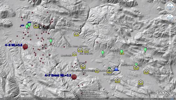
Figure 4.1. Map of Central Abruzzo and the central Aterno valley with the main shock fault plane and epicenters of April 6 and April 7 events. The villages of the Aterno valley are south east of the capital city of L'Aquila.
a. Damage to Castelnuovo and Surrounding Villages
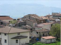
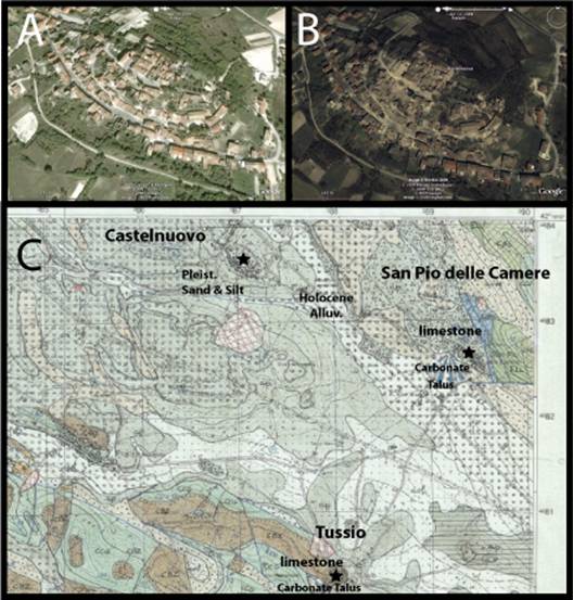
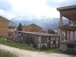
Castelnuovo: The village of Castelnuovo is located on a hilltop 10-70 m above the surrounding alluvial plain. The village (810-860 m elevation) is settled on an elliptical hill, consisting of fluvio-lacustrine deposits of lower to medium Pleistocene age. The village top is an eroded Pleistocene unit of weakly cemented sand with inter-collated gravel and conglomerate (Bosi and Bertini, 1970; Bertini et al., 1989). This unit lies on top of a soft erodable carbonate silt of the San Nicandro formation that was incised by the Aterno river during Pleistocene time. Holocene fluvial and alluvial deposits fill-in the topographic lows and surround the eastern and southern sides of the village (Figures 4.2; 4.3). The site is located 25 km southeast of the April 6 epicenter. During the reconnaissance, we observed outcrops of the weakly cemented sandstone near the top of the village in a sinkhole that formed among D5 collapsed structures. On the north side of the village at the base of the hill is an abandoned masonry ENEL seismograph station that was badly damaged during the earthquake (Figure 4.4).
(D)
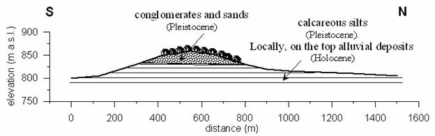
Figure 4.2. Castelnuovo village before the earthquake (A); the village after the earthquake (B); geologic map of the eastern Aterno Valley region; (C) Geologic map of the region (Courtesy of INGV); (D) Geologic section through the hill. Castelnuovo is built on Pleistocene sand and silt deposits, whereas nearby villages with the same building stock are located on Mesozoic carbonate Bedrock, and limestone talus.
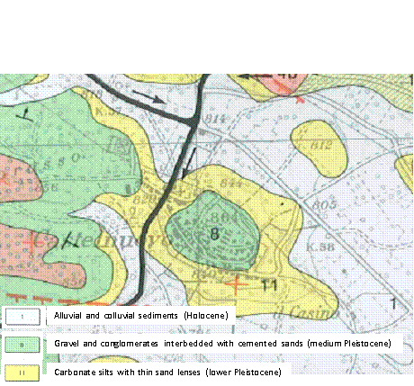
Figure 4.3 Geological map of Castelnuovo (modified after Bertini et al., 1989).
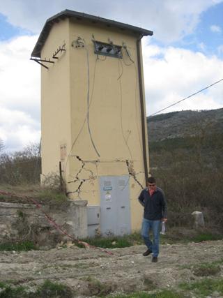
Figure 4.4. Heavily damaged Seismometer station box (not in use at the time of the earthquake, no recording) on the northeast valley beneath the town of Castelnuovo. (42.2982N, 13.6295E).
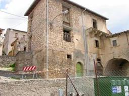
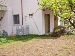
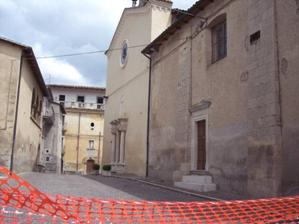
The village consists of un-reinforced masonry structures 2-3 stories in height. Some of the structures were retrofitted with through-going iron bars. Shaking was strong enough to significantly damage (D2 or greater) almost the entire village, with most of the structures in the upper half of the hill either collapsed or teetering on collapse (D3-D5). Figure 4.5 shows a D2 structure near the base of the village, where the D4-D5 Ratio was approximately 25%. In this area most structures survived the event. Figure 4.6 shows a series of collapsed structures near the top of the Hill, where the D4-D5 ratio was 80-90%. Figure 4.7 shows a sinkhole apparently associated with erosion from a water pipe break at this same location near the top of the hill. As described in Section 2.2c, the village of Castelnuovo was previously almost completely destroyed during the earthquake of 1461 (Rovida et al. 2009).
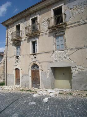
Figure 4.5. A typical heavily damaged structure in the lower elevation of Castelnuovo. Many structures in the lower elevation neighborhood had less observable damage. (42.2956N, 13.6274E)
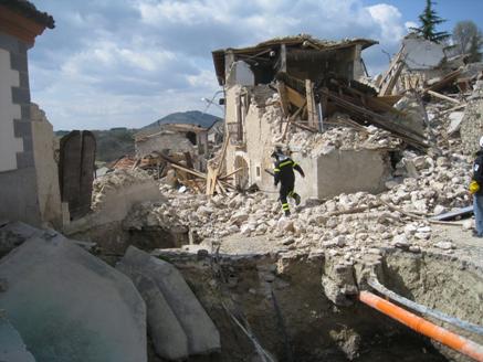
Figure 4.6. At the highest elevation of the hilltop town of Castelnuovo, almost all of the structures collapsed (D5) or were near collapse (D4). (42.2947N, 13.629E)
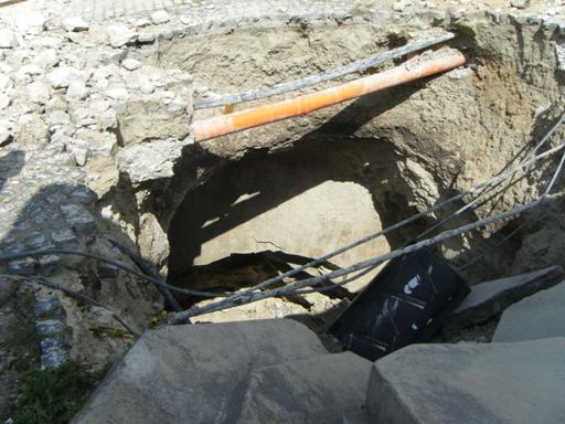
Figure 4.7. In the foreground of Figure 4.6 at the top of the hill in the center of Castelnuovo, a large sinkhole formed beneath the road exposing the weakly cemented Pleistocene sandstone that underlies the village. Water draining through the sinkhole was actively eroding a large void approximately 3-5 m in diameter and at least 6 m in depth. Cementation was strong enough to support small overhangs, at least temporarily (42.2947N, 13.629E).
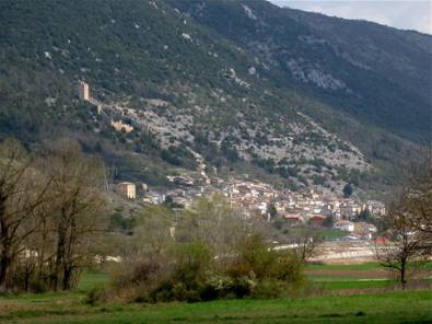
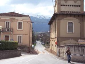
San Pio delle Camere: Castelnuovo is located 2 km northeast of the village of San Pio delle Camere, a hill slope village built on carbonate bedrock. This village is at a similar elevation above the valley floor and approximately 27 km southeast of the epicenter. The housing stock of the village is similar to Castelnuovo. This village had no observable significant damage to any of the structures. Several fine cracks were observed in the exterior walls of some of the two-story and three-story residences, as shown in Figures 4.8 and 4.9.
(A)
(B)
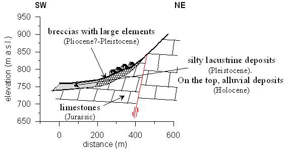
Figure 4.8. (A) The village of San Pio delle Camere built on Mesozoic limestone. This picture was taken from the lower flanks of Castelnuovo. (Picture taken from location 42.2898N, 13.6297E looking southeast) (B) Geologic cross-section through the village.
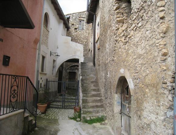
Figure 4.9. Typical unreinforced masonry structures in the village of San Pio delle Camere suffered no damage (D0), or slight cracking (D1). Structures in this village are similar to those in Castelnuovo. San Pio delle Camere is built on limestone bedrock.
Tussio: The village of Tussio is located 3.4 km south southeast of Castelnuovo and was built on limestone bedrock and carbonate alluvial fan debris. It is similar to San Pio delle Camere in that it was also built on the side of a hillslope on carbonate bedrock, and coarse debris. Tussio also suffered essentially no significant structural damage during the earthquake, as shown in Figure 4.10.
Based on the response of the structures, the shaking intensity at Castelnuovo was significantly greater than at San Pio delle Camere or Tussio. It is also noteworthy that the damage to the top of the village of Castelnuovo was considerably worse than at the base. Accordingly, Castelnuovo is a good candidate for a dense array of seismometer instruments to characterize the relative amplification of aftershock motions as compared with the surrounding villages, and also to characterize the difference between motions at the lower elevations of the town relative to the town center at the top of the hill. Some element of topographic amplification may have contributed to the strong shaking at the highest elevations of the village. However, there is no indication of damaging topographic amplification at San Pio delle Camere or Tussio.
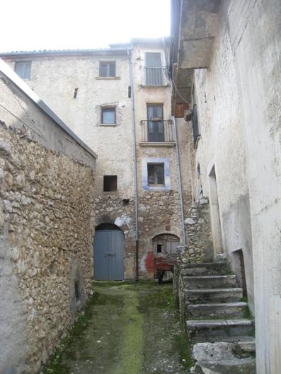
Figure 4.10. The reconnaissance team observable no damage to the town of Tussio. The town is built on Mesozoic calcareous bedrock (42.2657N, 13.6414E).
b. Damage to Onna and Surrounding Villages
Onna: The hardest hit village near the city of L'Aquila was Onna, an old village on the floor of the Aterno valley built on Holocene calcareous alluvial and fluvial deposits of sand and gravel, and inter-bedded clay and silt, some more than 5 m thick (Figures 4.12, 4.13). The village is in the valley thalweg on the left bank of the Aterno river. The village is similar to Castelnuovo in that it is composed mainly of 2-3 story unreinforced masonry structures, with a minority of retrofitted structures. Unlike Castelnuovo, this village has a small number of newer reinforced concrete residential structures (Figure 4.11). The village is 12 km away from the epicentre at an average elevation of 580 m elevation. The village overlies the fault rupture plane near its shallowest portion. Unreinforced masonry structures in Onna suffered a collapse (D5) rate of about 80% (Figure 4.14a). Reinforced concrete structures suffered minor or no damage. The intensity degree attributed by QUEST team was IX-X.
The town was previously destroyed by the historical earthquake in 1461 (Rovida et al., 2009). During that event, the village was reported to have suffered MMI = X, and an eighteenth century chronicler Anton Ludovico Antinori reported that 'Nella Villa di Onda ne tampoco resto casa impiedi' ('In the Onda village no house remained standing').
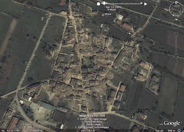
Figure 4.11. The village of Onna suffered D4 - D5 damage in most of the unreinforced masonry structures. Reinforced concrete structures at the margins of the village performed well with only minor damage (D0-D2).

Figure 4.12. L'Aquila geologic map close-up of Onna, San Gregorio, and Monticchio. Onna is built on Quarternary alluvium and suffered mostly D4-D5 damage in the masonry structures. Monticchio is built on Mesozoic limestone, and Quaternary breccia and suffered mostly D0-D1 damage. San Gregorio is built on Miocene limestone, Pleistocene Fluvial and lacustrine deposits, and Holocene alluvium. Damage was high in the historic center of town (mostly D4-D5). Damage was considerably lower on the limestone deposits (D0-D2).
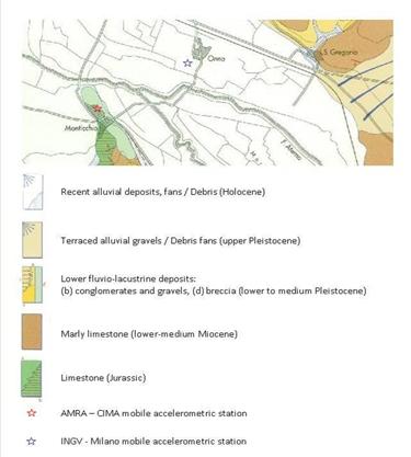
Figure 4.13. Geological map of Monticchio, Onna and San Gregorio (modified after Bosi and Bertini, 1970).
Onna is surrounded by a number of villages on various geologic units (Figure 4.12, 4.13). One village on a similar setting is a portion of San Gregorio, 1.2 km to the east. Portions of San Gregorio that were built on Holocene alluvial deposits, or fluvial lacustrian deposits of Pleistocene age, suffered high ratios of D4-D5 damage. In the historic center of the village, the D4-D5 ratios approach 100%, whereas portions of the village built on Miocene limestone suffered lower levels of damage. The village of Monticchio, 1.3. km southwest of Onna, is founded on Mesozoic limestone and Pleistocene breccia. This village suffered almost no damage in its unreinforced 2-3 story masonry residences nor any damage to reinforced concrete residential structures. The apparent elevated shaking intensity at Onna, as compared with the surrounding villages built on bedrock or stiffer alluvial debris, make it a good candidate for installation of a dense seismometer array to characterize site amplification effects of the valley fill relative to surrounding bedrock.
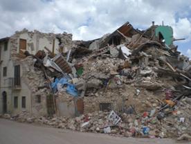 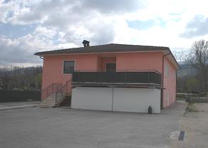
Fig. 4.14 Onna: (a) D5 damage level on masonry building structures;
(b) D0 damage on a RC building (except for the tilting of the chimney).
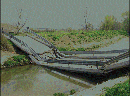
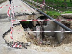
Heavy damage (D4 to D5) was also observed on two bridges crossing the Aterno river near Onna (Fig. 4.15 a,b). The first bridge (Fig. 4.15a) appears to have the collapsed when the displacement exceeded the limit of the bridge bearings. The second bridge failed due to associated to ground failure at the abutment (Fig. 4.15b).
(a) |
(b) |
|
|
Fig. 4.15. Onna: (a) collapse (D5) and (b) intense damage (D4) of RC bridges on the Aterno river.
Monticchio: The village on Monticchio is 11 km away from the epicenter on the right side of the Aterno river valley at an elevation around 600 m. It was built on a gentle slope at the toe of the northern part of Cavalletto mountain. In the south-western part of the village, Jurassic limestone outcrops (Figure 4.16). In other areas of Monticchio, this bedrock formation is covered by carbonate breccia of Pleistocene age, with thicknesses of 100 m and more.
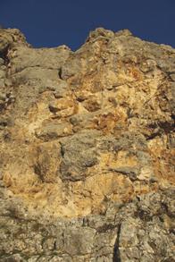
Fig. 4.16. Monticchio: outcrop of the Jurassic limestone formation.
The town is mostly 2-3 story masonry buildings and to a lesser extent RC buildings. The intensity degree attributed by QUEST team was VI. A D0-D1 damage was detected on both structure types throughout the village (see Fig. 4.17 a,b,c).
Fig. 4.17. Monticchio : (a) D0 damage level on different building structures; (b) D0 damage on monumental masonry buildings; (c) D1 damage (fall of the cornice) on a masonry building.
After the main shock, an accelerometer station was been installed by AMRA-CIMA to record the aftershocks sequence on a stiff formation. Due to its position relative to Onna, and the relatively low intensity of shaking on bedrock and stiff carbonate breccia, this town is a good reference site for evaluating site amplification effects at Onna where another mobile station was installed by INGV Milan.
San Gregorio: The village of San Gregorio is on the western flank of the Aterno valley at 600 m elevation. The epicentral distance is 14 km. The village extends over different geological formations (Fig. 4.18): the western part is founded on fluvio-lacustrine deposits (lower to medium Pleistocene) consisting of gravels and conglomerates (this part of the village is not shown in the Bosi and Bertini, 1970, geological map, below); the historic center was built on top of alluvial deposits; Miocene limestone outcrops in the eastern part of the village.
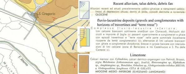
Fig. 4.18. Geological map of San Gregorio (after Bosi and Bertini, 1970).
The MMI intensity at San Gregorio reached IX and damage was mainly concentrated in the historic center founded on alluvium. At the town center, the majority of the buildings were constructed with poor quality masonry and most collapsed including the church (D5=75% and D4=25%) (Fig. 4.19). The western part of the village was built on Pleistocene gravels and conglomerates (Fig. 4.20) and did not have significant damage (50% D2, 25% D1 and 25% D0); the eastern part, largely consisting of RC buildings (Figs. 4.21, 4.22 founded on either alluvium and limestone showed different levels of damage (30% D4, 40% D3, 30% D2, 10% D1). San Gregorio is a good candidate for assessing site amplification effects in the same town over short baselines because of the different geologic units crossing the urbanized portions of the town. The limestone area in the eastern portion of the town would be an obvious candidate for a rock site to normalize the response of the alluvial section at the town's historic center.
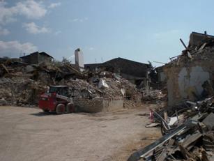 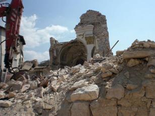
Fig. 4.19. San Gregorio: (a) view of the historic center with collapsed masonry buildings; (b) remains of the church.
Fig. 4.20. San Gregorio western part: masonry buildings with minor damages.
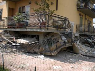 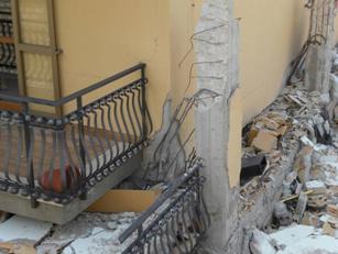
Fig. 4.21. San Gregorio eastern part: (a) RC building "pancake" collapse; (b) detail of sheared pillars.
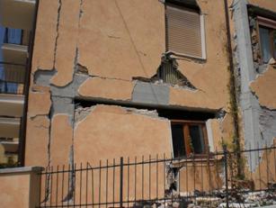 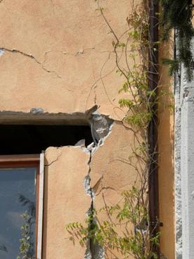
Fig. 4.22. San Gregorio eastern part: (a) RC building with structural damage; (b) detail of the damage to the beam-column connection.
4.2 Other Towns and Villages in the Aterno Valley Region
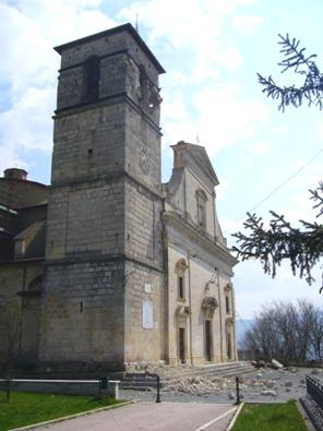
Fossa: The village of Fossa was built on the eastern flank of the Aterno valley (600-650 m elevation) along the slopes of Cavalletto mountain. It is 14 km from the April 6 epicenter, and the estimated MMI intensity was VII-VIII. Most of the village is built on talus debris from a ridge of Mesozoic limestone (Fig. 4.23). The historic center is comprised principally of 2-3 stories masonry buildings, whereas in the newer part of the village around the perimeter of the historic center is typically 2-3 stories RC buildings. Heavy damage (D3/D4) was mostly concentrated in the historic part of the village, where masonry buildings of poor and irregular brickwork had vertical cracks in the walls. In the rest of the village, composed of RC buildings and retrofitted masonry, had lower damage (D1-D2) (Fig. 4.24). The church of Santa Maria ad Criptas built in the middle-ages was heavily damaged (D3).

Fig. 4.23. Geological map of Fossa (after Bosi and Bertini, 1970).
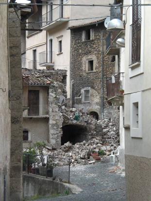 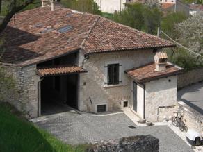
Fig. 4.24. Fossa: (left) collapse of masonry constructions in the historic center;
(right) strengthened masonry construction with no damage.
San Eusanio Forconese & Casentino: The villages of San Eusanio Forconese and Casentino are built on the eastern flank of the Aterno valley at 590 m and 630 m elevation, respectively. The epicenteral distance is 16 km for both towns. S. Eusanio village is built on fluvio-lacustrine deposits (medium Pleistocene) of sand and gravel with interbedded silts and clays. Casentino is built on talus debris (Fig. 4.25).
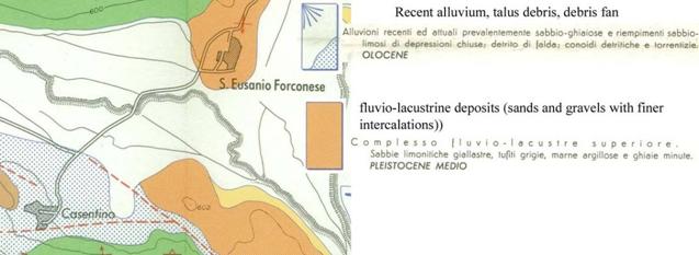
Fig. 4.25. Geological map of S. Eusanio Forconese and Casentino: (Bosi and Bertini, 1970).
The village of S. Eusanio is primarily composed of 2-3 story masonry buildings and, to a lesser extent, 2-3 story RC buildings. The MMI intensity was VIII-IX and the level of damage was high for the URM buildings (D4-D5~50%), whereas, low damage (D1) was observed in the RC buildings (Figs 4.26-4.28).
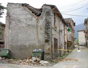 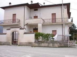
Fig. 4.26. S. Eusanio Forconese village: (a) partial collapse of masonry building (D4) and (b) slight damage to a RC building nearby (D1).
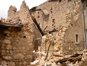 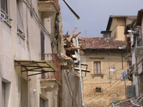
Fig. 4.27. S. Eusanio Forconese: (a) collapse of old masonry building (D5), and (b) partial collapse of masonry building (D4)
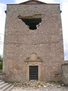
Fig. 4.28. S. Eusanio Forconese suffered partial collapse of the masonry church (D4).
Casentino: In Casentino the MMI intensity was VII-VIII. It was not possible to survey the inside the village, but from the access road we observed a high level of damage (D4-D5) for the masonry buildings, and low damage (D1) for the few RC buildings (Figs. 4.29, 4.30).
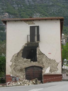 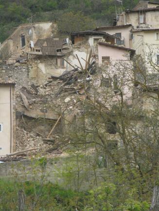
Fig. 4.29. Casentino: (a) partial collapse of the masonry building at the entrance of the village (b) collapse of old poor quality masonry buildings in the historic center.
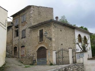
Fig. 4.30. Casentino masonry buildings with some wall cracks.
Poggio Picenze: This town (695-760 m elevation) lies along a slope located on the north side of the river Aterno valley, 17 km from the epicenter. The western side of the town is settled on a Pleistocene gravel and conglomerate (Fig. 4.31); most of the historical center is on softer colluvium and the carbonate silt of the San Nicandro formation (Fig. 4.32a, b), locally covered by Pleistocene gravel.
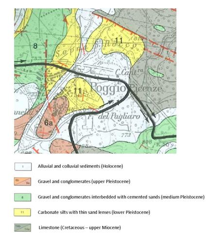
Fig. 4.31. Geological map of Poggio Picenze (modified after Bertini et al., 1989).
(a) |
(b) |
|
|
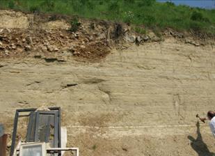
Fig. 4.32. Outcrop of (a) San Nicandro carbonate silts (note the gravel cover)
and (b) Pleistocene conglomerate.
The MMI intensity degree at Poggio Picenze was VIII-IX. The 1461 earthquake produced an MMI intensity of X. The buildings are an approximately equal number of masonry and RC houses, mostly 2-3 storys tall. Both irregular stone and higher quality regular stone masonry houses are found throughout the town: The irregular stone houses were more heavily damaged (Fig. 4.33a). In the historic center of the town, the masonry buildings including a monumental church (Fig. 4.33c) were heavily damaged (typically, D3-D4), whereas, nearby RC buildings were almost unaffected by the shaking (Fig. 4.33b). Minor damage was detected in the western and downhill parts of the town, where the soil is Pleistocene gravel and conglomerate.
Fig. 4.33. Poggio Picenze: (a) variable damage (D3-D4) on masonry buildings of different style, (b) undamaged RC house (D0) close to the (c) monumental church (D3).
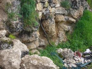
Villa San Angelo: The village of Villa San Angelo is at 560 m elevation on the east side of the Aterno river, at an epicentral distance of 19 km. The MMI intensity was IX. The village is built on fluvio-lacustrine deposits of lower to medium Pleistocene age. These deposits are alternating beds of calcareous silt and coarse gravel-conglomerate (Fig. 4.34).
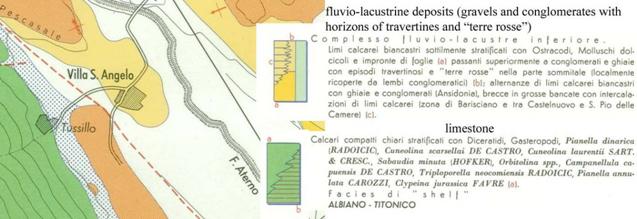
Fig. 4.34. Geological map of Villa S. Angelo (after Bosi and Bertini, 1970).
In the historic center with mostly 2-3 stories poor quality masonry buildings suffered high damage levels (30% D5, 40% D4, and 30% D3). The perimeter of the village has numerous 2-3 stories RC buildings that had minor damage of D1-D2. Retrofitted old masonry buildings performed well and had only minor cracks (Figs. 4.35, 4.36).
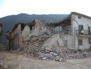 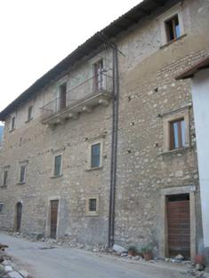
Fig. 4.35. Villa S. Angelo: (a) collapsed masonry buildings (D5) in the historic center; (b) reinforced masonry in the historic center with minor cracks in the highest story (D2).
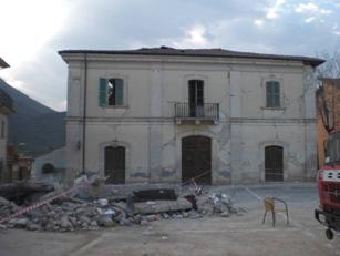 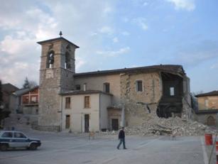
Fig. 4.36. Villa S. Angelo, historic center with (a) masonry building cracks; (b) partly collapsed church.
Tussillo : The village of Tussillo raises on the eastern flank of the Aterno valley at 600 m elevation and is very close to Villa S. Angelo. Unlike Villa S. Angelo, the intensity felt at Tussillo was VII-VIII. The village is built on limestone (Fig. 4.37). Buildings are of 2-3 stories masonry or reinforced concrete. The level of damage was D4-D5 for some of the older construction in the historic center, though no survey inside the village was allowed. Generally, the level of damage was lower than that observed in Villa S. Angelo.
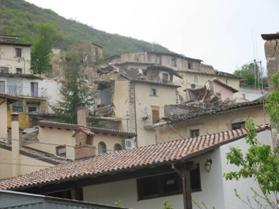 
Fig. 4.37. Tussillo: (a) view of the historic center with some collapsed masonry buildings on the background; (b) masonry building at the entrance of the village showing no damage.
San Demetrio ne' Vestini:The village of San Demetrio ne' Vestini is on the western flank of the Aterno valley, between 670 and 700 m elevation, about 20 km from the epicenter. The village sits on Pleistocene gravels and conglomerates (Valle dell'Inferno unit), and partly on gravel and sand (San Giovanni unit) (Fig. 4.38).
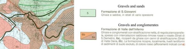
Fig. 4.38. Geological map of S. Demetrio ne' Vestini (Bertini et al., 1989).
The older part of the village mainly consists of 2-3 story masonry buildings of generally of higher quality to those of the surrounding villages. Modern 2-3 story RC buildings form the town perimeter. The MMI intensity felt was VI-VII. The level of damage was low for masonry as well as RC buildings (30% D0, 60% D1 and 10% D2) (Figs. 4.39-4.40).
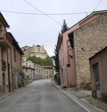 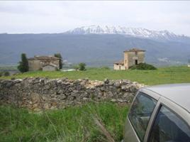
Fig. 4.39. San Demetrio ne' Vestini (a) access road to the village showing mostly masonry buildings with no damage, (b) old masonry buildings with no damages
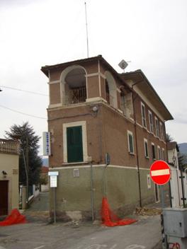 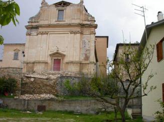
Fig. 4.40. San Demetrio ne' Vestini: (a) "Caserma dei Carabinieri" with cracks (not evident in the picture) and falls from the highest story, (b) partial collapse of the tympanum of the facade of the Madonna dei Raccomandati church.
A few very old buildings, such as the Madonna dei Raccomandati church, were severely damaged (D4). The damage to the uppermost "Via Crucis" stations along a slope close to the village might indicate evidence of topographic amplification (Fig. 4.41).
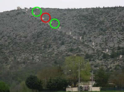
Fig. 4.41. San Demetrio ne' Vestini: damages at the "Via Crucis" stations constructed along the slope
Barisciano: The village of Barisciano is at 900 and 1000 m elevation, 21 km from the epicenter. It lies along a slope to the north of the Aterno river valley. It sits on a middle-lower Cretaceous-upper Miocene carbonate ridge (grey in Fig. 4.42). The town center rests upon coarse calcareous Pleistocene breccia (light blue in Fig. 4.42).
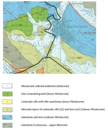
Fig. 4.42. Geological map of Barisciano (modified after Bertini et al., 1989).
The town center midway up the slope is mostly 2-3 story masonry construction, and more recent 2-3 story reinforced concrete structures are present uphill and downhill of the center. The MMI intensity was VI, but, there was some damage at level of D4/D5 level for some old masonry buildings (Fig. 4.43 a). Most structures were damaged at D1 levels (Fig. 4.43 b).
(a) |
(b) |
|
|
Fig. 4.43. Barisciano: (a) collapse (D5) of an old masonry building in background; (b) damages (D1/2) to RC buildings. |
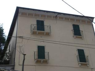
Goriano Sicoli: The village of Goriano Sicoli raises on the eastern flank of the Aterno valley at 720 m elevation; with an epicentral distance of 48 km. The village lies partly on limestone bedrock, and partly on talus debris and alluvial fan (Fig. 4.44).
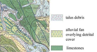
Fig. 4.44. Geological map of Goriano Sicoli (Carta Geologica d'Italia 1:50000).
The majority of the buildings are 2-3 story masonry buildings and RC buildings. The MMI intensity was VII. The damage was generally low (D1) in the part of the village founded on the bedrock, while significant damage (D3-D4) was observed in the western part of the village founded on talus debris and alluvial deposits (Fig. 4.45). San Gemma church was also significantly damaged (D3).
(a)
(b)
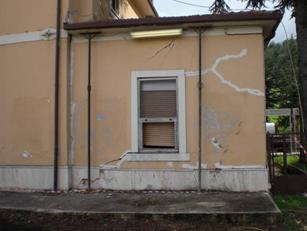
Fig. 4.45. Goriano Sicoli: (a) diagonal cracks in a masonry building (D3) and (b) at the railway station (D3).
4.3 Damage Patterns within L'Aquila
a. Pettino Fault Region
The Pettino fault daylights NW of the L'Aquila city center with a NW-SE trend, as shown in Figure 2.8 and 4.46. West of the A24 highway, the fault marks the boundary between hills steeply dipping towards the southwest and sloped Pleistocene sediments, as shown in Figure 4.46. In this area there is almost no construction on the northeast side of the fault, as shown in Figure 4.47. The fault continues as a concealed trace on the east side of the A24 highway as shown by the red line in Figure 4.46. A survey of damage patterns in the vicinity of the fault was performed. The specific areas investigated are marked in yellow in Figure 4.48.

Figure 4.46. Geology of the L'Aquila region (modified from INGV)
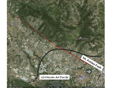
Figure 4.47. (a) Geology of the L'Aquila region (modified from xxx, 19xx) and (b) satellite photo (from Google Earth) showing the Mt. Pettino Fault and its extension towards northwest.
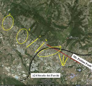 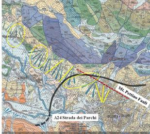
Figure 4.48. Satellite photo from Google Earth of the L'Aquila showing the traces of the building damage survey lines in yellow.
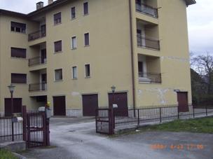
Within the zones marked in Figure 4.48, structure-by-structure damage surveys were performed in which structural performance was mapped according to the categories shown in Table 4.1. These relatively rapid structural assessments were based on the exterior appearance of the buildings from the street. Each damage level was assigned a colored marker in the map, as defined in Table 4.1. Figure 4.49 shows a general view of the damage survey results. This is a recently developed suburban area of L'Aquila, therefore most buildings are relatively modern reinforced concrete frame structures with masonry infill on exterior walls. Most residential buildings are two to four-stories high, with apartment buildings closer to the city center reaching 5 or 6 stories. The few collapses observed in the damage survey were of four-story reinforced concrete buildings, typically at the ground floor level. Many structures in this area were not damaged, and where damage occurred, it generally involved relatively minor cracking (D1) to relatively severe cracking or collapse (D2) of the masonry infill walls. Incidents of serious structural damage in categories D3 or greater was relatively rare. It is possible the survey was not detailed enough to capture damage at the level of the single structural element from the outside; however, whenever D2 damage was visible, we took particular care to examine the structural elements that were visible.
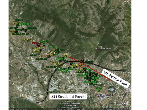
Figure 4.49. Satellite photo from Google Earth of the L'Aquila with a general view of the building damage survey.
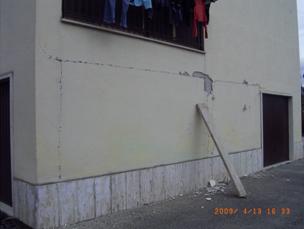
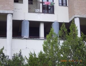
Figures 4.50 and 4.54 show close-up views of the mapped zones marked (a) to (e) in Figure 4.48. Zone (a) is the easternmost mapped area. The concentration of structures with damage level D3 is higher in this area than anywhere else along the Mt. Pettino Fault. Waypoints GB-80-1 and GB-82-1 are both masonry structures (Figure 4.51a and b). The first one is an older and abandoned building, while the second was a family residence (Figure 4.52). The remaining waypoints are reinforced concrete structures with masonry infill ranging between 2 and 5 stories. Of the five structures in this zone with damage classified at the D3 level, four are 3-stories, and the fifth is a 4-story building. An example of D3 damage (from the building at waypoint GB-88-1) is shown in Figure 4.52.
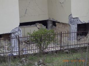
Another area with a number of collapsed buildings is located in zone (a). These are all reinforced concrete structures, 3- to 4-story high in which the ground floor columns collapsed, causing it to pancake (Figure 4.53). Although high levels of damage are concentrated in this small area, similar buildings on adjacent streets show D2-level damage.
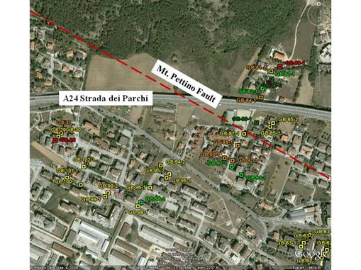
Figure 4.50. Zone (a) of the building damage survey along the Mt. Pettino Fault.
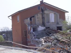 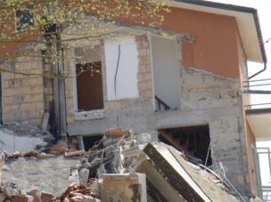
Figure 4.51. Masonry structure at waypoint GB-82-1.
 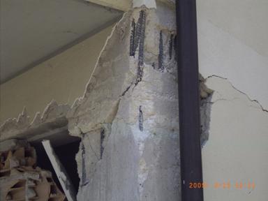
Figure 4.52. Example of D3 damage in the building at waypoint GB-88-1.
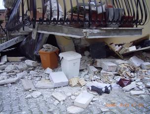 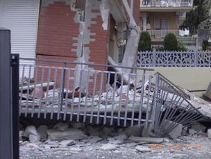
Figure 4.53. Example of D5 damage in the building at waypoints GB-27-1 and GB-28-1.
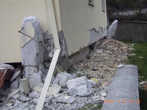
Damage in zone (b) of the survey was generally lower, with only a few structures suffering D2 levels (Figure 4.54). Moving northwest, damage levels increase in zone (c), with a higher concentration of apartment buildings with minor structural damage (D3). Many of these buildings are actually the same design oriented differently. The area of collapsed buildings in zone (d) is isolated. Figure 4.54 shows in detail the location of the buildings in the damage cluster and Figures 4.55-4.57 show examples of damage in this area. The ground floor collapsed in the structures at waypoints GB-23-1 and GB-24-1. From conversations with the owners of units in the lightly damaged building, structures at waypoint GB-22-1 (D1) and GB-24-1 (D5) were built by the same construction company, but GB-24-1 was built a year before the other. Similarly, GB -23-1 (D5) was constructed by the same company as GB-25-1 (D2). All buildings were constructed in the mid-1980s. New construction to the southeast of GB-26-1 (D2) showed no damage at all (D0) in spite of the rigid external brick cladding.
In zone (e) at the northwest end of the surveyed zone, the damage falls to D0 and D1 levels (Figure 4.54).
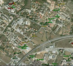 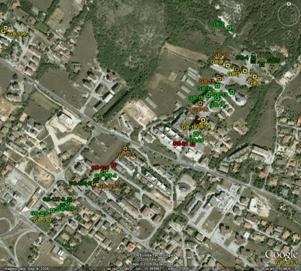
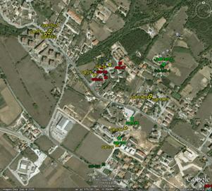 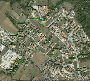
Figure 4.54. Results of the building damage survey along the Mt. Pettino Fault: Zones b, c, d, and e.
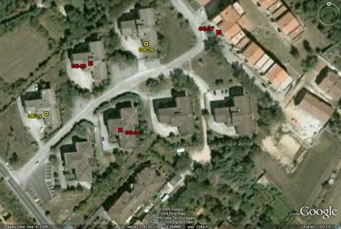
Figure 4.55. Cluster of damage in zone (d).
(a) Waypoint GB-22-1 (D1) (b) Waypoint GB-23-1 (D5)
Figure 4.56. Damage on the structures in the cluster in zone (d).
(c) Waypoint GB-24-1 (D5)(d) Waypoint GB-25-1 (D2)
(e) Waypoint GB-26-1 (D2)
Figure 4.57. Damage on the structures in the cluster in zone (d) (cont.)
b. Damage patterns across swell and valley deposits north of L'Aquila town center
As shown in Figure 4.58, north and west of the L'Aquila town center, the Pleistocene terrace deposits on which most of L'Aquila sets are eroded, and the resulting channels are partially filled with Holocene sediments. Some of those channels are developed with similar styles of construction to thise on the adjoining terrace deposits. The type of construction is generally similar that described in Section 4.3 a above -- mostly RC structures of 3-6 story height, although there are some masonry buildings as well.
Where we have adjoining this terrace/channel deposits, we typically found higher damage levels in the swales. Detailed mapping was performed to document these damage patterns, but this work has not been compiled as of yet. We hope to release these results in subsequent version of this report.
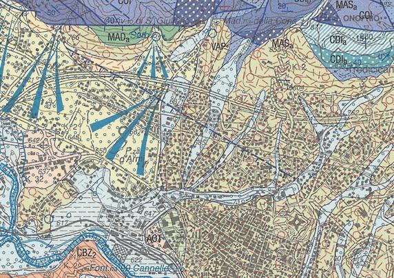
Figure 4.58. Geological map of the area north of L'Aquila old center.
|
 (c)
(c)