6.0 Performance of Dams and Earth Retaining Structures
6.1 Campotosto Dams
Campotosto lake is a man-made water reservoir with a capacity of 315,000,000 m3, at an altitude of 1313 m above sea level. It is located approximately 20 km north of L'Aquila, between Gran Sasso and the Laga Mountains. As shown in Figure 6.1, the lake is impounded by three dams: Sella Pedicate (42.514954N, 13.369194E), Rio Fucino (42.535047N, 13.410323E) and Poggio Cancelli (42.558380N, 13.338944E). Reservoir filling was completed in the 1970's and its water is used for electrical power production. The dams were visited by the reconnaissance team on April 14 2009.
The Campotosto basin is placed at the site of an ancient lake which later became a peaty marsh due to mud silting. This is apparently the result of transport of bed load of the tributaries whose basins consist of highly erodible sandstone-marl rocks. A factor contributing to the drying up of the ancient lake was the constant deepening of the Fucino gorge by erosion. The basin consists of cemented sandstone layers and banks, chiefly clayish, alternating with marl banks and thin layers of clay schists of the middle Miocene [ENEL, 1980].
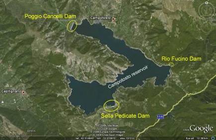
Figure 6.1. Campotosto reservoir map with the location of the three dams.
Over most of its length "Sella Pedicate" dam is a concrete dam while at one of its extremities it is a zoned earthfill embankment with an clayey central core and a concrete foundation diaphragm. It is 25 m tall and 750 m long. Its construction dates from the 1950's. Figure 6.2 shows a plan view of the dam from GoogleEarthTM. The upstream face is very steep (possibly 5 horizontal to 1 vertical) and is shown in Figure 6.3. The downstream face has a much milder inclination. Following the main shock of April 6 2009, the water level was lowered by ENEL by approximately 2 m to reduce water pressure on the structure. The reduction in water level is evident in Figure 6.3.
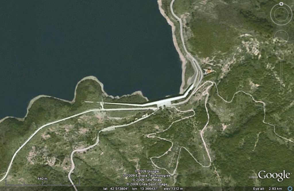 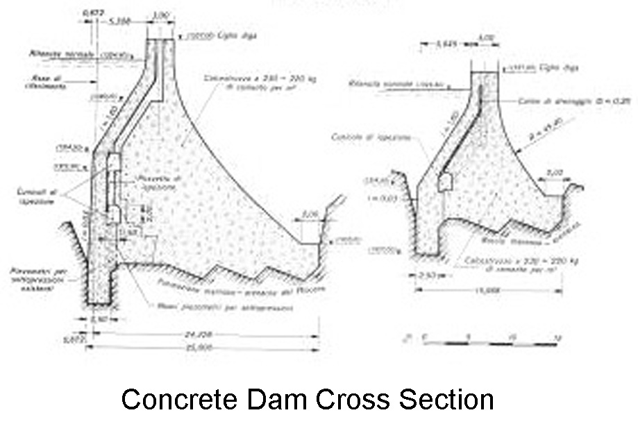
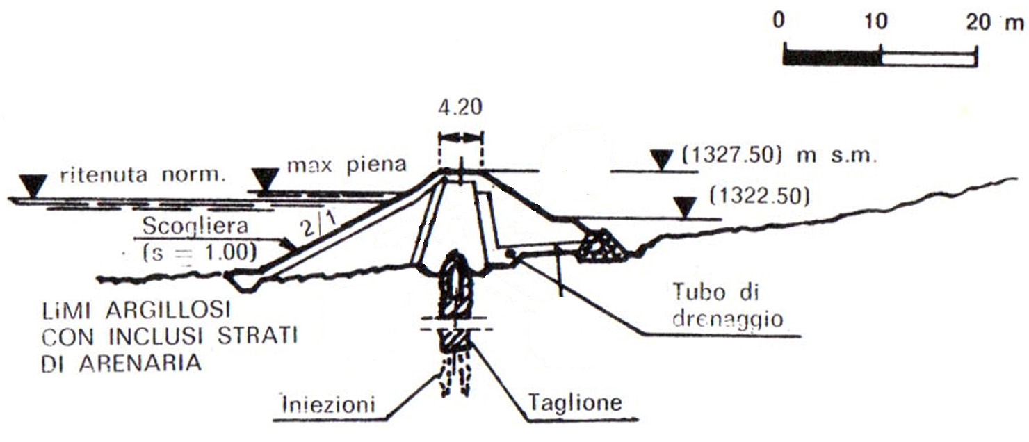
Figure 6.2. Plan and cross sectional (concrete dam central portion, earthfill embankment end portion) views of Sella Pedicate (42.514954N, 13.369194E) dam and adjacent highway system.
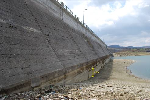
Figure 6.3. Upstream face of Sella Pedicate dam. The reduction in water level decided by ENEL following the main shock is evident in the photo (42.514954N, 13.369194E).
At the time of the earthquake the water depth behind the dam was about 25 m. No earthquake damage was observed in the dam (crest, slopes, abutments). In addition, no soil liquefaction with sand ejecta was observed along the shoreline in the vicinity of the reservoir.
"Rio Fucino" is a concrete dam with a length of approximately 150 m and a reported maximum height of 49 m (Simonelli et al 2009). Its construction dates from the same period as in the other dams. No damage was observed, as evident in Figures 6.4-6.6. According to ENEL employees of the local station, the dam is instrumented with seismic measuring devices, which recorded peak accelerations of the order of 0.1g. Acceleration histories from those instruments are not available as of this writing.
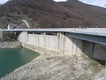
Figure 6.4. Upstream face of Rio Fucino dam. Note the reduction in water level (42.535047N, 13.410323E).
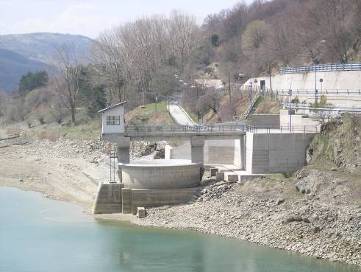
Figure 6.5. View of the outlet tower of Rio Fucino dam (42.535047N, 13.410323E) .
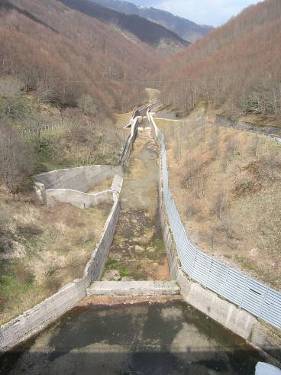
Figure 6.6. View of spillway of Rio Fucino dam (42.535047N, 13.410323E).
"Poggio Cancelli" is a zoned earth dam approximately 500 m length and 30 m in height. The inclination of the upstream face is about 3 horizontal to 1 vertical while that of the downstream face is approximately 1 horizontal to 1 vertical. No information as to instrumentation is currently available. At the time of the earthquake the freeboard was estimated to be about 20 m. Figure 6.7 and Figure 6.8 show the main embankment, which was found to have no visible damage from the earthquake. Moreover, no liquefaction was observed in the surrounding area.
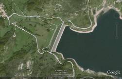 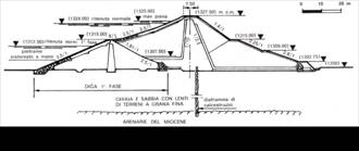
Figure 6.7. Plan and cross sectional views of Poggio Cancelli dam (42.558380N, 13.338944E).
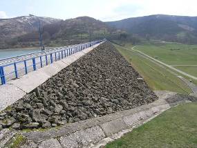 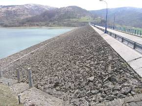
Figure 6.8. Downstream (left) and upstream (right) face views of Poggio Cancelli dam from the north abutment (42.558380N, 13.338944E).
6.2 Penne Dam
Penne lake is a man made water reservoir at an altitude of 250 m above sea level. It is located approximately 43 km east of L'Aquila and Gran Sasso Mountain. As shown in Figure 6.9, the lake is impounded by one earth dam (42.438809N, 13.913265E) 350 m in length. Although no members of the team have visited the dam to date, we have corresponded with ENEL staff who have surveyed the dam and found no evidence of structural or soil damage.
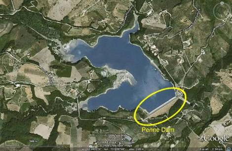
Figure 6.9. Location map for Penne reservoir and dam (42.438809N, 13.913265E).
6.3 Earth Retaining Structures
Earth retaining structures were generally observed to have performed well during the earthquake. No port structures (e.g., quay walls) were located in the meizoseismal area, hence the observed walls retain partially saturated (nonliquefiable) soils. In the region of interest, retaining structures are typically masonry walls, of the type shown in Figures 6.10-6.18. A number of reinforced concrete walls also exist in L'Aquila and did not suffer significant damage (Figure 6.17). In general, damage varied between minor detachments of stones, (Figure 6.13) to full collapse or toppling (Figure 6.16). No concentration of retaining wall damage at specific geographic coordinates was observed.
The wall failure shown in Figure 6.14 is nearly aligned with the pavement crack shown in Figures 6.15 and 6.16. Note that offset of the nearby (250m away) cracked wall of Figure 6.17, is practically parallel to the pavement crack of Figures 6.15 and 6.16. There has been some speculation that these ground cracking patterns may be related to co-seismic rupture (see Section 2.3).
 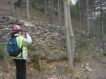
Figure 6.10. Minor damage on masonry wall in severely shaken Pettino area (42.374011N, 13.367498E).
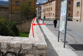 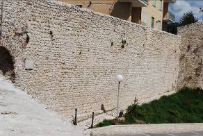
Figure 6.11. Stone masonry wall at L'Aquila city (42.348710N, 13.403900E). Note the (tolerable) outward movement at the center of the wall and the pavement cracks behind the wall.
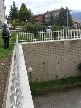
Figure 6.12. Undamaged wall at the severely shaken Pettino area (42.373050N, 13.366106E).
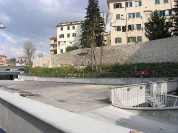
Figure 6.13. Damaged wall at downtown L'Aquila (42.356056N, 13.389524E).
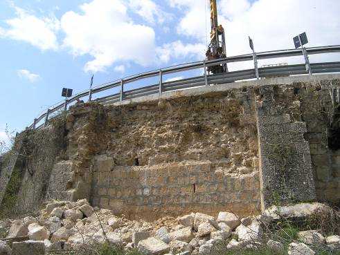
Figure 6.14. Partially collapsed wall at SS80 highway between L'Aquila and Campotosto (42.420510N, 13.358394E).
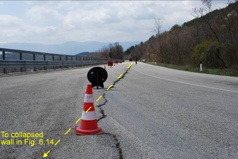
Figure 6.15. Pavement cracking in SS80 roadway (from L'Aquila to Campotosto) in the location of collapsed masonry retaining wall (42.420510N, 13.358394E).
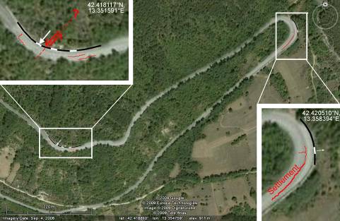
Figure 6.16. Locations of observed pavement cracking and associated retaining wall failures.
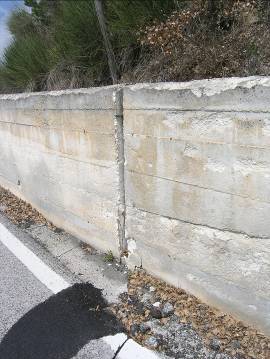 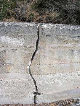
Figure 6.17. Ruptured retaining wall due to slope instability at SS80 highway between L'Aquila and Campotosto (42.418117N, 13.351591E).
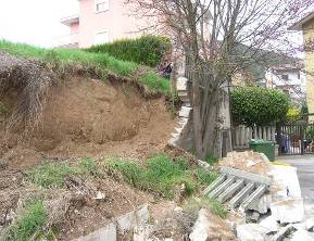 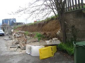
Figure 6.18. Toppling of masonry retaining wall at the outskirts of L'Aquila (42.366803N, 13.376561E).
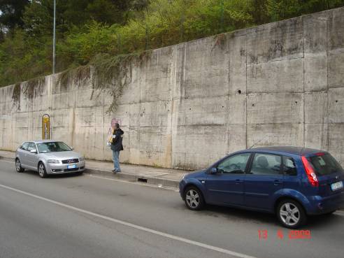
Figure 6.19. Undamaged retaining wall at the city of L'Aquila (42.343672N, 13.398821E)
|