2.2 Geologic Setting
The geology in the Kobe area is fairly complex and is dominated by a number of northeast/southwest trending strike-slip faults. Basement bedrock of Late Cretaceous and Miocene age form the mountainous region to the north and west of downtown Kobe. The dominant rock type northwest of Kobe is a biotite granite known as the Rokko granite. Other basement rock types include sandstone, conglomerate, mudstone, and tuff. Pleistocene gravel, sand, and clay terrace deposits lie to the southeast of the basement rock outcrops that are terminated by a system of right-lateral faults (Rokko fault zone), which include, from southwest to northeast, the Suma, Egeyama, Suwayama, Ashiya, Koyo, and Arima-Takatsuki faults. The Pleistocene deposits are overlain by Holocene alluvium (sand, gravel, and clays) that form the relatively level, narrow corridor of land which contains most of the development in the Kobe area. A map depicting contours of the base elevation of the Holocene deposits in the Kobe area is presented in Figure 2.2. The Holocene alluvium thickness generally increases to the southeast from roughly 20 m under downtown Kobe to as much as 40 m under the Port Island. Much of the exposed land near the Kobe waterfront, including the islands, is reclaimed land that was constructed by loosely dumping granular material generally borrowed from the decomposed Rokko granite. To the east of the Kobe area, alluvial deposits brought down by rivers such as the Yodo River dominate the surficial geology; whereas, to the west on Awaji Island, outcropping basement rock bordered by narrow shorelines consisting of Pliocene alluvium with some Holocene alluvium at the shore comprises the surficial geology. The basement rock is terminated along the northwestern flank of Awaji Island by the Nojima fault and along the southeastern flank of the island by a parallel fault system. The basement rock under central Osaka Bay is at depths on the order of 2 km, and it rises to depths between 0.5 to 1.5 km below central Kobe. A recent assessment of the subsurface geology by Iwasaki (1995) has located basement rock at depths between 1.7 and 2.0 km at Port Island and at a depth of about 2.5 km at Rokko Island.
 Figure 2.2: Holocene base elevation contours. Source: Iwasaki (1995).
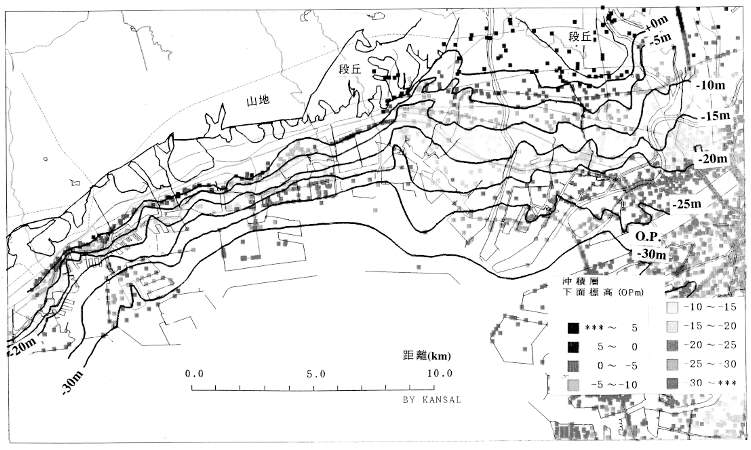 Figure 2.2: Holocene base elevation contours. Source: Iwasaki (1995).