3.5 Tank Foundations
General observations. There are numerous tank farms in the area most severely affected by the earthquake. Some of the tank farms are associated with the port facilities, while others provide storage for refineries, fossil fuel power plants, and chemical manufacturing facilities. Most of the tanks surveyed from the air appeared to have performed well, and there were no reports of widespread damage to tanks even within port areas disturbed by severe liquefaction effects. The generally good performance of tanks may be due to the apparent practice of placing tanks on pile foundations. However, there were a few exceptions to the generally good performance; these few instances of poor performance may have been due to use of mat foundations in areas where liquefaction occurred. The following sections describe observations noted at selected tank farms visited by team members during this reconnaissance.
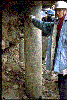
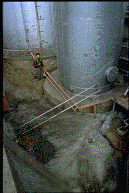
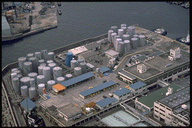
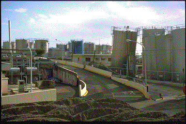
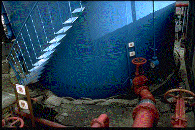
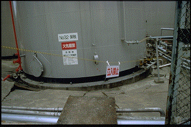
Higashinada Power Station Fuel Tank. The Higashinada Power Station is owned and operated by the Kansai Electric Power Company, Inc., and is located on the southwest corner of a man-made island, Uozaki-Hamacho, near the north side of Rokko Island (Figure 3.1). Figure 3.59 provides an aerial view of the facility. Estimated peak ground accelerations in this area were 0.5 g to 0.7 g. As with many of the man-made harbor fills in the Kobe area, the island experienced extensive liquefaction. Figure 3.60 shows the south quay wall of the island which displaced laterally toward the water. This lateral movement was associated with two major fissures bracketing a 5-meter-wide tension zone located approximately 10 to 15 meters behind the south quay wall. There was also movement and cracking along the quay walls on the west side of the island. Numerous sand boils erupted within the power station complex, fissures formed, pavements fractured and separated, and the ground settled differentially. A group of tanks used to store fuel and water for the power station was constructed approximately 50 to 60 meters inland from the quay walls. An excavation had been made around the perimeter of one of the tanks to expose the piles for inspection of damage (Figure 3.61). The tank, reportedly supported by 33 piles extending to depths of approximately 33 meters, was undamaged. The piles consist of reinforced-concrete sections with diameters of approximately 35 centimeters. Twelve of the 33 piles were arranged in an outer ring near the perimeter of the tank (Figure 3.62); the rest are situated closer to its center. Beneath the tank, the ground had liquefied and settled 28 centimeters. Lateral spreading near the tank seemed to have been insignificant. From within the perimeter excavation, daylight was visible between the tops of the piles (Figure 3.63).
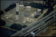 Figure 3.59: Aerial view of Higashinada power station.
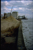 Figure 3.60: South quay wall near Higashinada Power Station.
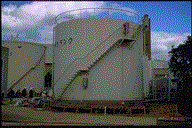 Figure 3.61: Damaged pile-supported tank at the Higashinada PowerStation.
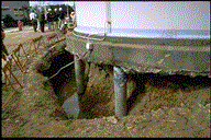 Figure 3.62: Close up view of the exposed perimeter piles supporting the tank shown in Figure 3.61.
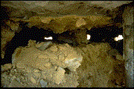 Figure 3.63: Gap beneath the tank mat created by settlement of liquefied soil.
Damage to the exposed portions of the piles appeared to be relatively light. Several piles contained hairline cracks in the upper meter or two (Figures 3.64). At least one pile contained intersecting cracks that could allow large of concrete to spall out. The most seriously damaged piles were located along the northwestern part of the perimeter. The piles appeared repairable and thus were not classified as having failed.
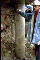 Figure 3.64: Excavated upper part of pile foundation beneath the tank shown in Figure 3.61.
Hanshin Silos. The Hanshin silos are located a few hundred meters to the east of the Higashinada Power Station on Uozaki-Hamacho (Figure 3.1). Some of these silos are visible in the background of Figure 3.60. Several silos, at the western end of a complex of attached silos, sustained significant structural damage. As shown in Figure 3.65, the tops of the western silos are irregular due to differential settlement, and parts of the silo skins appear to have buckled and sheared. One of the silos collapsed and damaged an adjacent wharf and crane structures. This site was not visited on the ground during this reconnaissance and no information on foundation type or cause of failure was obtained. However, due to the widespread liquefaction on the island, ground failure must be considered a potential contributor to the observed structural failure. A point worth investigating is why the majority of the silos appeared to perform well whereas those on the western end suffered distress and failure.
 Figure 6.65: Aeriel view of the Hanshin silo complex.
Karumojima Tanks. Field reconnaissance in the western Kobe area of Karumojima near the Port of Nagata identified several small tank farms. Most of this area consists of man-made fills situated around the channelized mouths of the Karumo and Minato Rivers. This area was estimated to have sustained peak ground accelerations of between 0.5 and 0.7g. Extensive liquefaction was observed in this area in the form of sand boils, differential settlements, and quay wall distress. Figure 3.66 shows a view along one of the channels affected by slumping of quay walls. In the background of the photograph are several tanks which tilted in one or more directions. The ground around these tanks contained several large fissures, presumably associated with the lateral spread, and sand boils had erupted through many of the fissures (Figures 3.67).
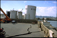 Figure 3.66: Tilted tank at the Karumojima tank farm. Note the ground cracking due to lateral spreading in the foreground.
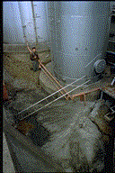 Figure 3.67: Fissures and sand boils within Karumojima tank farm.
The tilting of the smaller diameter tanks appeared to be a result of one side of the foundation mat sinking into the ground, presumably a result of liquefaction. Although there was no information available regarding foundation type and no excavation had been made at the site, the performance of the mats for the smaller tanks suggested that they were founded at shallow depth and were not supported by piles. The tilting of the large tank is thought to have occurred in a similar manner. However, the large tank had a perimeter concrete collar ring which separated from the tank as the tank settled into the ground (Figure 3.68). Although this separation led to an offset of several centimeters at the collar ring, it is not known if a structural failure of the mat was involved.
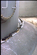 Figure 3.68: Displaced collar ring around a large tank in the Karumojima tank farm.
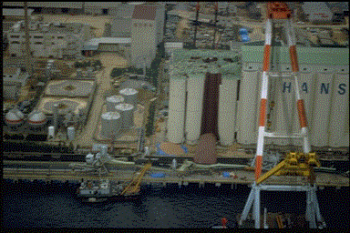
Nippon Gatx Tanks. Nippon Gatx Company, Ltd. operates a tank farm located at the Port of Nagata in the western Kobe area. Figure 3.69 is an aerial view of this tank farm. There are several dozen tanks at the facility that are used to store chemicals such as ethylene glycol, alcohol, and water. The terminal manager for the facility reported that none of the tanks were on piles and several of these tanks were observed to be tilted after the earthquake (Figure 3.70). As at the Karumojima tank farm, the cause of the distress appeared to be liquefaction of foundation soils as evidenced by several sand boils and ground fissures that developed in the area. The mats settled differentially, with one end sunken into ground and covered with ejected sand (Figures 3.71 and 3.72).
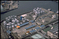 Figure 3.69: Aerial view of the Nippon Gatx tank farm.
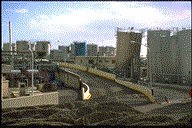 Figure 3.70: Tilted tanks in the Nippon Gatx complex.
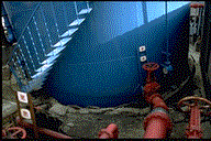 Figure 3.71: Differential settlement at the base of a water tank in the Nippon Gatx complex.
 Figure 3.72: Differential settlement at the base of a chemical tank in the Nippon Gatx complex.
 Figure 3.59: Aerial view of Higashinada power station.
 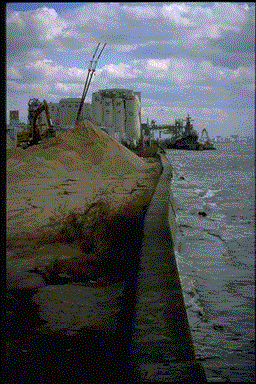 Figure 3.60: South quay wall near Higashinada Power Station.
  Figure 3.61: Damaged pile-supported tank at the Higashinada PowerStation.
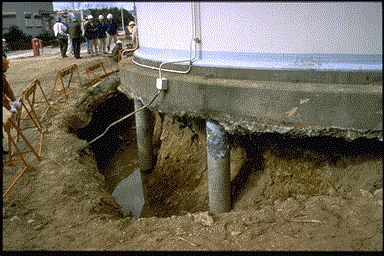 Figure 3.62: Close up view of the exposed perimeter piles supporting the tank shown in Figure 3.61.
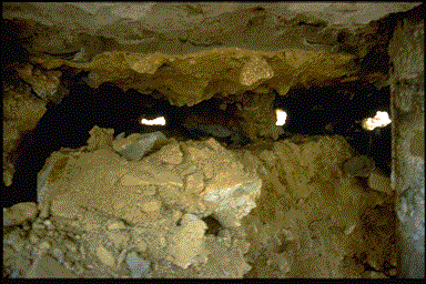 Figure 3.63: Gap beneath the tank mat created by settlement of liquefied soil.