5.2 Performance of Levees
There are several small rivers which flow past Kobe and Osaka to Osaka Bay. Most of these rivers have been channelized as they pass through the urban areas to reach the bay. This means that the river is commonly confined by gravity and cantilever retaining walls similar to those which channelize the Los Angeles River. In some places, armored earth embankments are also used as levees. In general, aerial reconnaissance indicated that most of these water retention facilities performed well. The exceptions to this was cracking and slumping observed along the Yodo River Levee and distress observed on a levee along a tributary of the Mukogawa.
5.2.1 Yodo River Levee
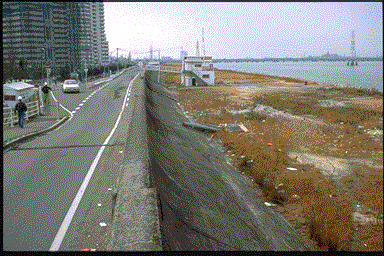
The Yodo River is the principal river in the region (see Figure 3.1). The earthquake was estimated to have induced peak ground accelerations of approximately 0.2 to 0.3g in this area. Approximately 1.5 to 2 kilometers of levee on the south, or Osaka, side of the river experienced major damage in the form of extensive cracking and slumping. The levee along this portion of the river is an earth embankment commonly 6 to 8 meters in height. The levee is generally about 7 meters in width and incorporates a 1.5-meter-high concrete parapet wall on the waterside edge of the crown . Both the waterside and the landside slopes of the levee are covered by concrete slabs to prevent erosion failure from overtopping by flood waters. The levee crown has generally been paved with asphalt concrete.
The mode of damage appeared to consist of the levee embankment breaking up into blocks and sinking into and spreading out over a liquefied foundation. At the time of the earthquake, the river stage was relatively low and apparently saturated only about the bottom meter or two of the levee embankment. As a result of the earthquake, the foundation and/or bottom portions of the levee presumably liquefied, resulting in the failure of the levee. At several locations, the levee embankment settled over 3 meters, almost half its total height. Figures 5.18 and 5.19 show the seriously damaged levee. At the time of the reconnaissance, the levee had received initial repairs consisting mainly of adding fill to restore freeboard. To prevent erosion due to rainfall or seepage, the unarmored repaired areas were covered with blue, plastic sheets.
 Figure 5.18: Aerial photograph of failed Yodo River levee after initial repairs.
 Figure 5.19: Upstream slope of failed Yodo River levee after initial repairs (note horizontal stairway).
Support for the theory that foundation liquefaction was responsible for the serious damage was obtained by examining levee reaches approximately a kilometer east, or upstream, of the seriously damaged levee area. In this eastern area, the levee performed generally well with only isolated reaches sustaining moderate damage in the form of cracking and settlements of up to a meter. In this area, the foundation soils are slightly above the river level and are exposed on the waterside of the levee. As shown in Figure 5.20, several sand boils could be observed in the foundation opposite an area of moderate damage. The improved performance further east may be because the foundation becomes denser as one moves upstream, or perhaps the effect of the relatively lower water level reduced the total amount of foundation or levee materials that liquefied. Reports in the Japanese media also indicated that reaches of the north levee on the Yodo River and some reaches of levees on the Kansaki River sustained similar levels of minor to moderate damage.
 Figure 5.20: Moderately damaged Yodo River levee (note sand boils on exposed waterside foundation).
5.2.2 Mukogawa Tributary Levee
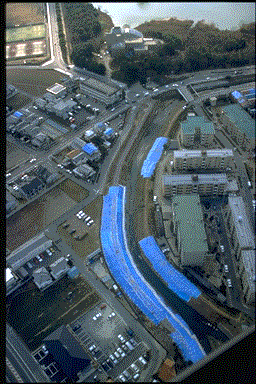
Figure 5.21 presents an aerial photograph of levees confining a tributary of the Mukogawa. This site is located approximately 8 kilometers north of Amagasaki in the eastern Kobe area (Figure 3.1). The photograph shows the levee crowns on both sides of the channel to be covered with blue, plastic sheeting. This was presumably because the levees had sustained cracking, and perhaps slumping, and the plastic sheets were placed to prevent rainfall from infiltrating into the cracks. Portions of the levee beneath the plastic sheets appear to be significantly distorted and may be indicative of serious damage. The earthquake was estimated to have induced peak ground accelerations of approximately 0.3 to 0.4g in this area. No field reconnaissance was performed on the ground at this site.
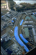 Figure 5.21: Aerial photograph of distressed levees on tributary to Mukogawa.
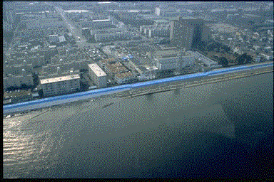 Figure 5.18: Aerial photograph of failed Yodo River levee after initial repairs.
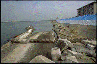 Figure 5.19: Upstream slope of failed Yodo River levee after initial repairs (note horizontal stairway).