Chapter Seven: Slopes, Retaining Structures, and Landfills
7.1 Landslides and Rockfalls
7.1.1 Introduction
The topography of the region to the north of downtown Kobe, and to the north of the Osaka Bay in general, rises rapidly into the Rokko Mountains, reaching an elevation of 930 m at the highest point. This terrain is generally characterized by relatively steep slopes and short steep valleys. The main rock type in the area is granite, which is deepely weathered and decomposed to saprolite to a considerable depth. The decomposed granite is susceptible to rock falls and debris flows, and the hillslopes show numerous scars from slope failures, as can be seen in the aerial view of the hills shown in Figure 7.1. Most of these scars were apparently caused by rainfall-induced debris flows, and, for the most part, only minor ravelling and rockfalls were reported as a result of the earthquake. Nevertheless, one large flow slide did occur in the decomposed granite in a residential area in the Nigawa district of Nishinomiya, northeast of Kobe. This slide killed 34 people and caused extensive property damage. In addition, considerable damage also occured due to movement of structural fills in residential areas on hillsides, particularly along the projection of the strike of the earthquake fault, and isolated rockfalls also caused localized damage.
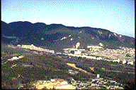 Figure 7.1: Aerial view of the landslide scars in the hills north of Kobe.
7.1.2 Nigawa Landslide
The Nigawa landslide appears to have been a rapidly moving debris slide in decomposed granite. The slide occurred immediately adjacent to the Uegahara filtration plant, along the edge of a large terrace/bench at an elevation of about 100 m. The aerial view of the site in Figure 7.2 shows the head scarp of the slide and most of the deposition area at the toe. Figure 7.3 shows the evidence of runup of the the debris on a building at the base of the slope (second from the bottom left in Figure 7.2). The length of the head scarp was approximately 100 m and the the distance from the headscarp to the toe of the slide was about 250 m, with a vertical drop on the order of 30 to 40 m. The failed portion of the terrace appears to have been a part of a cut-and-fill extension of a pre-existing natural ridge and saddle, and the mobilized material seemed to be a combination of decomposed granite fill and intact saprolite. The presence of fill was evident along the headscarp which undermined a building, exposing its pile foundation (Figure 7.4). The upper portion of the slope was heavily wooded, and a housing development was built along a series of terraced slopes starting about 15 to 20 m below the crest of the slope. As can be seen from the photographs, the houses in the path of the slide mass were completely obliterated and buried by the slide debris.
 Figure 7.2: Aerial view of the Nigawa landslide showing the steep arcuate head scarp and a flatter depositional area at the toe.
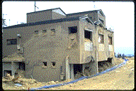 Figure 7.3: Debris stained 3 story building at the toe of the slide (the building is second from the left at the bottom of the photograph in Figure 7.2). Note that the debris invaded the structure without causing extensive structural damage to the exterior walls.
 Figure 7.4: Head scarp of the Nigawa landslide. The stratification of soil below the pavement suggests that this upper material is fill. The foundation of the building is pile supported.
The flow like nature of the slide was evident from well-defined levees as high as 6-8 m along the flanks of the slide mass in the lower part of the slope, and the slide debris flowed down a creek bed at the toe of the slope for some distance. The role of water in the mobilization of the slide could not be immediately ascertained. The landslide debris, decomposed granite composed primarily of sand with some fines and some coarser material, appeared to be relatively dry on the surface immediately following the failure. However, wet seep areas became evident with time, at an elevation approximately equivalent to the base of the wooded slope, and the landslide debris was too soft to walk on in those areas.
7.1.3 Rock Falls
Isolated rock falls occurred from natural and cut slopes in the residential area of Nishinomiya. The natural weathering of the granitic rocks leads to the exposure of isolated, rounded granitic boulders precariously perched on the hillslopes. Once loose, they tend to roll downhill quite easily. A boulder approximately 3 m in diameter descended several tens of meters down a wooded slope, crossed a paved road, and crushed a mid-size car and damaged a wrought iron gate at an entrance to a residence (Figures 7.5 and 7.6). At another location, smaller rocks fell from a cut slope behind a residential building, but did not cause any damage because the slope support system was designed to deflect falling rock (Figures 7.7).
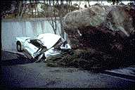 Figure 7.5: A car was flattened by this boulder, approximately 3m in diameter, the largest of several which rolled down the hillslope.
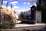 Figure 7.6: A view of the boulder shown in Figure 7.5 resting against the gate at the entrance to a driveway.
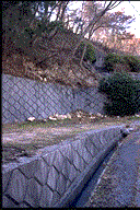 Figure 7.7: Freshly fallen rock at the basee of a retaining wall in a residential area.
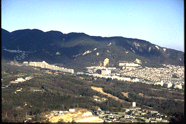 Figure 7.1: Aerial view of the landslide scars in the hills north of Kobe.
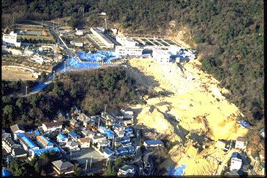 Figure 7.2: Aerial view of the Nigawa landslide showing the steep arcuate head scarp and a flatter depositional area at the toe.
 Figure 7.3: Debris stained 3 story building at the toe of the slide (the building is second from the left at the bottom of the photograph in Figure 7.2). Note that the debris invaded the structure without causing extensive structural damage to the exterior walls.
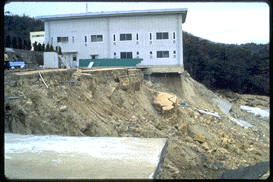 Figure 7.4: Head scarp of the Nigawa landslide. The stratification of soil below the pavement suggests that this upper material is fill. The foundation of the building is pile supported.
  Figure 7.5: A car was flattened by this boulder, approximately 3m in diameter, the largest of several which rolled down the hillslope.
  Figure 7.6: A view of the boulder shown in Figure 7.5 resting against the gate at the entrance to a driveway.
 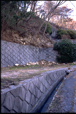 Figure 7.7: Freshly fallen rock at the basee of a retaining wall in a residential area.