7.4 Solid Waste Fills
Documenting the seismic performance of solid waste landfills is important to US practice as the Code of Federal Regulations(United States, 1991) requires that landfills located in seismic impact zones be designed to resist earthquake hazards, yet well-documented case histories which could provide insight are lacking. Recent earthquakes, such as the 1989 Loma Prieta and 1994 Northridge earthquakes, are providing some useful case records, but additional case records are needed. With this in mind, a few solid waste landfills located in the Kobe/Osaka area were surveyed. Unfortunately, detailed landfill geometry and waste fill characteristics are not currently available, and it appears that these landfills are not similar to US waste fills (i.e. due to aggressive recycling efforts, the Japanese waste is relatively inert compared to US waste, and, consequently, containment and gas collection systems are not designed at current USEPA Subtitle D standards).
There were a number of temporary waste fills located on newly reclaimed land in Osaka Bay just south of Nishinomiya, but these fills appeared to be set up only to burn and to dispose of construction debris being cleared from the damaged areas following the earthquake (Fig. 7.22). Two existing large waste fills further to the east were surveyed. The first waste fill (shown in Fig. 7.23) is located west of downtown Osaka on a reclaimed island about 20 km from the zone of energy release. This fill was inspected from the air. Several ground cracks, which were tens of meters long and a few centimeters wide, were identified near the southwest corner of the island. The series of north-south trending cracks appeared to have resulted from ground displacement toward the edges of the island. No evidence of liquefaction was observed, but it would not take much lateral spreading to develop these cracks. Similar ground distress was identified at the second solid waste landfill (shown in Fig. 7.24) which is sited atop a reclaimed island located at the southern tip of the Yodo River, about 12 km from the zone of energy release. A series of ground cracks occurred at the southwest corner of this landfill, which is reportedly lined with a geosynthetic material. One of the larger cracks is shown in Figure 7.25. The width of this crack was roughly 2 to 6 cm with a minor vertical displacement. It cut across the southwest corner of the reclaimed island and appeared to have resulted from lateral movements toward the edges of the island. Other, less continuous, cracks were located to the east of this crack near the southern edge of the island. Surficial evidence of liquefaction in the form of sand boils with ejected garbage was found on this island. Thus, lateral spreading associated with softening of the dumped soil fills could have easily produced the surface cracks noted. However, there was no evidence of any compromise of the waste containment systems at these waste fills.
 Figure 7.22: Burning and disposal of debris on reclaimed island south of Nishinomiya.
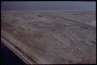 Figure 7.23: Ground cracks (lower right) at waste fill site west of Osaka.
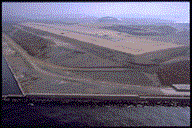 Figure 7.24: Overview of waste fill site at southern tip of the Yodo River.
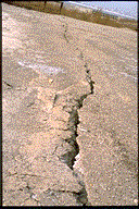 Figure 7.25: Close-up view of a ground crack in the southwest corner to the right of the site shown in Figure 7.22.
In summary, waste fill performance was dominated by the sites selected for the surveyed landfills. These sites were reclaimed ground constructed by methods similar to those discussed previously in Chapter 3 which experienced ground cracking resulting from liquefaction-induced lateral spreading. It appears that lateral spreading of the underlying saturated cohesionless fills produced the observed ground cracking. These case records illustrate the potential problems associated with waste fills constructed on ground susceptible to liquefaction.
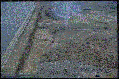 Figure 7.22: Burning and disposal of debris on reclaimed island south of Nishinomiya.
 Figure 7.23: Ground cracks (lower right) at waste fill site west of Osaka.
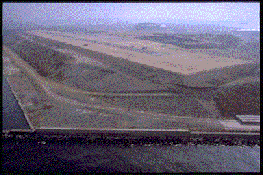 Figure 7.24: Overview of waste fill site at southern tip of the Yodo River.
  Figure 7.25: Close-up view of a ground crack in the southwest corner to the right of the site shown in Figure 7.22.