Initial Geotechnical Observations of
the August 17, 1999, Kocaeli Earthquake
A report of the Turkey-US geotechnical earthquake engineering
reconnaissance team
On August 17, 1999 at 3:02 AM a magnitude Mw 7.4 earthquake struck the Kocaeli area in the Northwest Turkey, which has a population of 20 million inhabitants (one third of Turkey’s total population) and encompasses nearly half of the country’s industry. This is one of the most devastating earthquakes of the twentieth century in view of the number of casualties and damage.
On August 29, 1999, preliminary rapid response estimates from the US 39th Air Expeditionary Squadron were that the death toll could be as high as 40,000, with the hardest hit cities being Golcuk/Degirmendere with 1 million people temporarily homeless. The Office of the UN Resident Coordinator in Ankara reports that the Prime Ministry Crisis Management Center (PMCMC) put the casualty figures at 13,479 dead and 27,164 injured as of August 28, 1999. On August 28, 1999, the PMCMC also estimated that 54,295 buildings were damaged. According to the Reconstruction Minister K. Aydin, the number of buildings which have collapsed and which will have to be demolished because of heavy damage is 27,000. He expects the number to reach 35,000 when their ongoing survey is completed. The Minister estimates that more than 200,000 housing units will have to be built. These numbers are likely to change as more information becomes available.
The earthquake epicenter was located at Izmit along the North Anatolian Fault, a strike-slip fault which presents many similarities to the San Andreas fault in California.
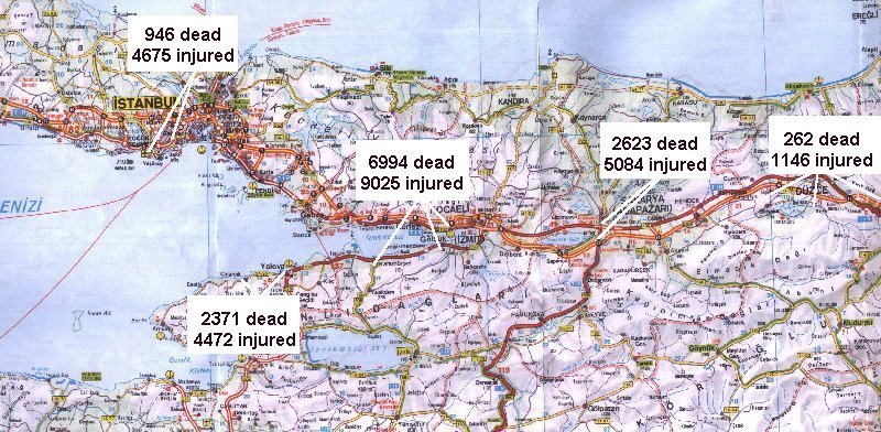
Emergency Response in TurkeyLocation of main damaged areas
The earthquake damage is widespread in the Izmit bay in the East-West direction over a length of 100-150 km and is concentrated in several areas, including Izmit, Golcuk, Avcilar, Yalova, Adapazari, and Karamursel (map from )
This brief report summarizes the initial observations of the advanced party of the Turkey/US geotechnical reconnaissance team sponsored by the US National Science Foundation and various organizations from Turkey. This report covers the initial reconnaissance efforts between August 24 and August 31, 1999. Ongoing work will lead to more comprehensive reports in the future. The members of the advanced party are:
We would like to express all our thanks to our Turkish and American colleagues who helped us in our reconnaissance effort and to express our sympathy to the victims of this natural disaster.