Introduction
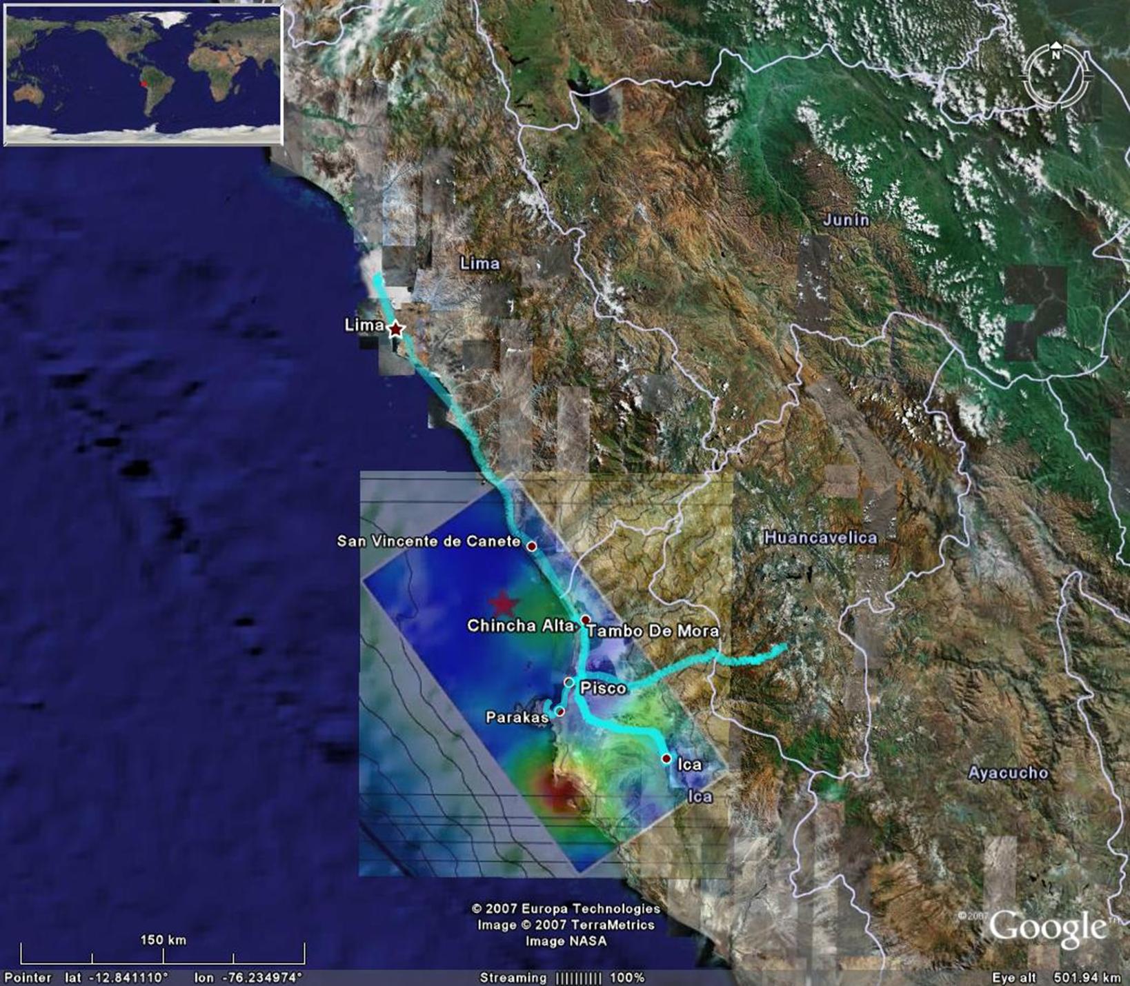
On Wednesday, August 15 2007, at 6:40 PM local time, a Mw 8.0 earthquake shook the coastal region of central Peru. The earthquake has been referred to as the Pisco or the Ica earthquake (Pisco being the most affected city, and Ica being the state where the cities of Pisco and Ica are located). The earthquake caused severe damage to the cities of Pisco, Ica, Cañete, and Chincha, and was strongly felt in Lima, the capital city of Peru. In response to this event, the Geotechnical Earthquake Engineering Reconnaissance (GEER) organization, with funding from the National Science Foundation (NSF), organized a reconnaissance team to document the geotechnical aspects of the earthquake. The GEER team arrived in Peru on August 20, 2007 and stayed for six days. It visited the cities of Lima, Paracas, Pisco, and Ica, and traveled the north-south roads connecting these major cities with additional smaller coastal towns (Figure 1.1). Additionally, the reconnaissance team traveled the major east-west road connecting Pisco with the city of Ayacucho to document the inland-extent of geotechnical failures.
From a geotechnical perspective, the Pisco earthquake was most significant for the amount of soil liquefaction observed in the mesoseismal zone and the considerable damage it caused to urban areas and the transportation infrastructure. Subsequent to the introductory section, this preliminary report addresses seismological considerations, including a discussion of recorded ground motions (Section 2), soil liquefaction and its effects (Section 3), and landslide occurrence along major highways (Section 4). Following after the philosophy of previous earthquake reconnaissance reports, the information presented herein is only intended to detail observations and data collected during the reconnaissance effort. This report does not document all of the findings of the GEER team. Rather, it is meant to be a summary that sheds light on some of the most important geotechnical aspects of the Pisco earthquake.
Summary of Earthquake Damage and Observed Intensities
The Pisco earthquake caused severe damage within its mesoseismal area. As of September 3, 2007, 519 people were confirmed dead, with at least 42 more unaccounted for and 1,874 reported injured. (National Civil Defense Institute, INDECI). INDECI also reports that 54,926 buildings were destroyed and an additional 20,958 buildings were damaged by the earthquake. The majority of the fatalities occurred in the city of Pisco, where by some estimates 80% of the buildings either collapsed or were seriously damaged.
The Geophysical Institute of Peru indicates modified Mercalli intensities of VII in the cities of Pisco, Chincha and Cañete, V to VI in Lima, III in Cuzco, and II in Arequipa (Tavera et al. 2007). In addition, the earthquake was felt as far away as Quito, Ecuador, La Paz, Bolivia, and Manaus, Brazil (USGS). The earthquake generated a tsunami that caused considerable damage in the city of Paracas, and inundated portions of many other cities/towns along the coast (a Google file with Tsunami observations prepared by the Peruvian Geophysical Institute, in Spanish, can be accessed here).
|
|
Figure 1.1 Overview of affected area. Path in blue indicates the road coverage of the reconnaissance team. The finite fault solution of Ji and Zeng (2007) is also shown. (Background image from Google Earth). |
GEER Reconnaissance Team members
Adrian Rodriguez-Marek, Washington State University (Team Leader)
Brady Cox, University of Arkansas
Jorge Meneses, Kleinfelder Inc.
Viviana Moreno, Catholic University of Peru
Manuel Olcese, Catholic University of Peru
Rodolfo Sancio, Golder Associates
Joseph Wartman, Drexel University
In addition, Dr. Jorge Alva Hurtado of the Universidad Nacional de Ingeniería contributed directly to the preparation of this report and to the reconnaissance effort.
The GEER reconnaissance team collaborated in the field with a multi-disciplinary team from the Earthquake Engineering Research Institute (EERI), and is in the process of collaborating with other teams still performing field reconnaissance (as of 9/4/07). The preliminary findings of the EERI team, as well as additional information about the earthquake, may be found on the EERI web site.
Acknowledgements
This post-earthquake reconnaissance effort was made possible by funding from the U.S. National Science Foundation and volunteer work by the team participants. The reconnaissance was sponsored and coordinated by the GEER organization under the leadership of Dr. Jonathan D. Bray (U.C. Berkeley). Financial support was also provided by EERI under the Learning from Earthquakes grant of NSF.
Cooperation with the following other researchers and organizations was invaluable:
The GEER reconnaissance effort benefited from coordination with the EERI reconnaissance team led by Dr. Eduardo Fierro. The EERI reconnaissance team was also composed of Adolfo Matamoros, Santiago Pujol, Arturo Schultz, Don Ballantyne, Mario Rodriguez, and Mikael Gartner.
The GEER reconnaissance team also benefited from the invaluable collaboration of the Centro Peruano Japonés de Investigaciones Sísmicas y Mitigación de Desastres (CISMID), part of the Universidad Nacional de Ingeniería (UNI). In particular, we would like to acknowledge the help of the director Dr. Carlos Zavala for establishing a clearinghouse in his facilities and of Dr. Zenón Aguilar. Dr. Jorge Alva-Hurtado met with the team before the reconnaissance effort and shared his pictures and observations of damage and geotechnical effects. Dr. Alva-Hurtado is a co-author of this report.
We would like to acknowledge the help of the Catholic University of Peru (PUCP) for providing logistical support. In particular, Dr. Marcial Blondet allowed the use of the PUCP facilities for meeting space and provided secretarial support as well as logistical support for car rental and other such necessities. Prof. Manuel Olcese not only participated in the reconnaissance effort, but allowed the free use of the Soil Mechanics Laboratory for meeting space and testing of collected soil specimens. Viviana Moreno conducted all the laboratory tests.
We would like to thank the Geophysical Institute of Peru (IGP) for their collaboration. Dr. Ronald Woodman (Executive President), Dr. Leonidas Ocola, and Dr. Hernando Tavera met with team members and provided invaluable insight into seismological aspects of the earthquake. The preliminary report of earthquake damage by Dr. Tavera (Tavera et al. 2007) is the basis for the seismological aspects section of this report.
Prof. Jorge Zegarra Pellane of the Catholic University of Peru helped us with pre-trip logistics and contributed photographs from an earlier visit to the affected sites. Efraín Rondinel-Oviedo of MWH Americas also helped to collect information prior to the reconnaissance trip.
The ground motion data presented in this report was obtained from PUCP, CISMID and IGP. While typically made available from their respective websites, these institutions allowed us early access to their data to facilitate our work.
Gonzalo Montalva, of Washington State University, and Ben Mason, of U.C. Berkeley, helped with the preparation of this web report.
A large number of additional individuals helped us during this reconnaissance, including people affected by the earthquake that despite their travails were very willing to give us information. We extend to them our best wishes and sincere thanks. Some names may be missing due to our mistake alone. Our gratitude goes to all those that collaborated.
This material is based upon work supported by the National Science Foundation under Grant No. CMMI-0323914. Any opinions, findings, conclusions or recommendations expressed in this material are those of the authors and do not necessarily reflect the views of the National Science Foundation.