[Back to
index]
Landslides
Landslides
triggered by the earthquake were observed during ground reconnaissance involving
vehicular traverses along both the Lima-to-Ica segment of the Pan-American
Highway (north-south oriented) and the east-west oriented Highway 024A. The
Highway 024A traverse originated near the coast close to Pisco and continued
east along the highway roughly 110 km inland to an elevation of
approximately 4,500 m. It is estimated that in total the earthquake triggered
thousands of landslides, with a significant majority of these being disrupted
landslides including rock falls, rock slides, soil falls, soil avalanches, and disrupted soil
slides (see Keefer 1984 for detailed descriptions of these categories).
Disrupted slope failures occurred in both natural and altered (e.g. road cuts)
terrain. Reports by the highway department indicate that rockfalls occurred
over a vast region stretching as far a north as the Department (State) of
Chachapoyas, at approximately 700 km from the fault plane (see
newspaper insert in Spanish). As noted earlier,
many liquefaction-induced lateral spreads were also observed, mostly along the
coast in the epicentral region. The following paragraphs discuss several
noteworthy landslides.
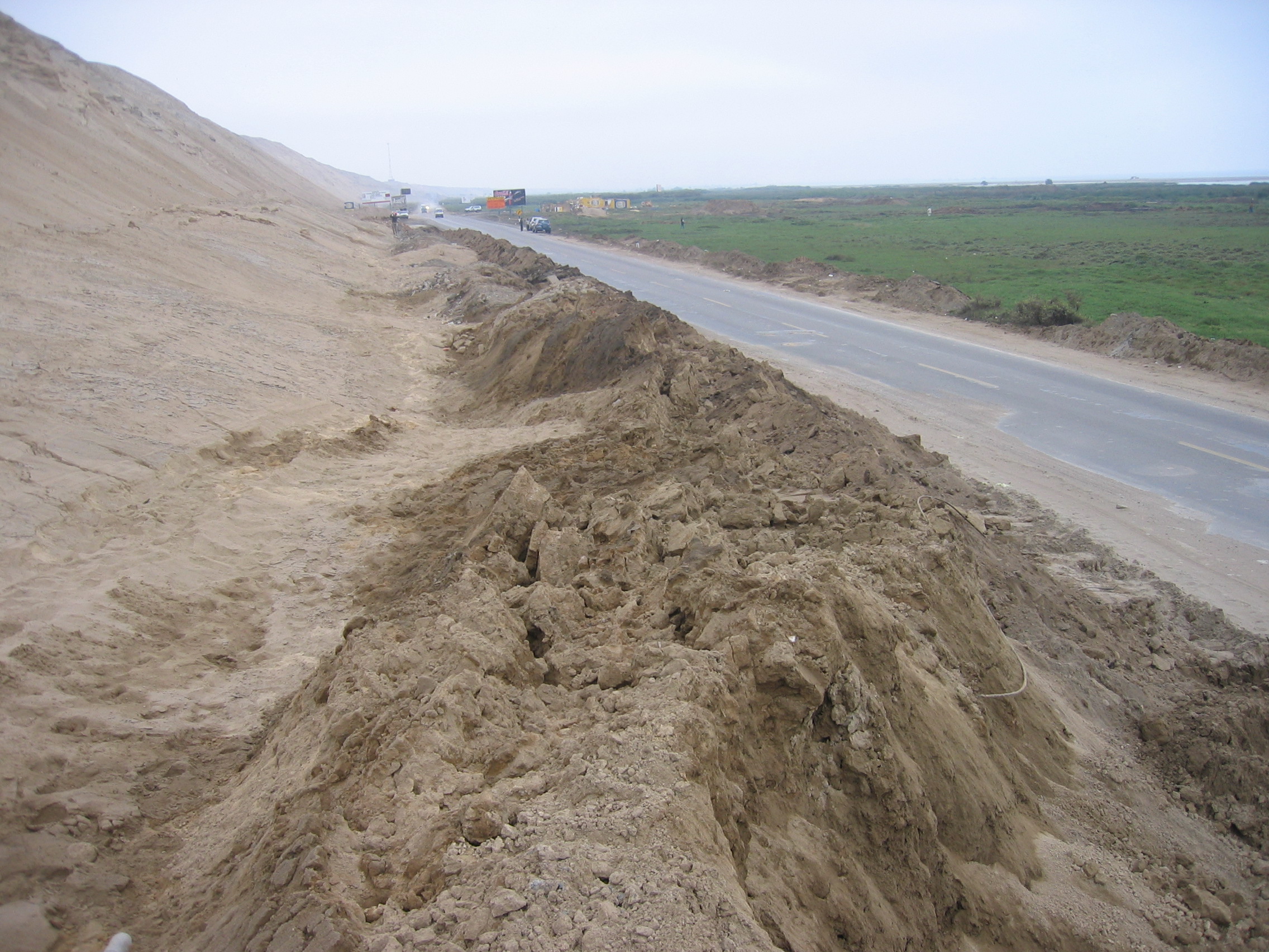
Figure 4.1
shows a complex soil avalanche thought to be triggered by liquefaction-induced
soil softening or ground movement near the toe of the slope. The landslide
occurred near Jahuay along the Pan-American Highway, which was partially blocked
at this location after the earthquake. This feature is discussed in the
Liquefaction Section (Section 3.2).
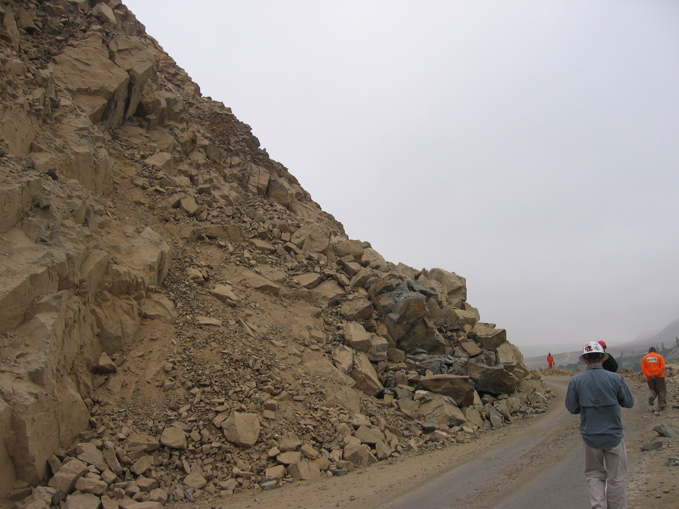
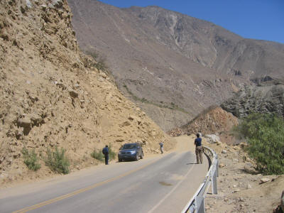
The massive
rockfall shown in Figure 4.2 occurred along Highway 024A
roughly 44 km from the fault plane at an elevation of approximately 500 m.
The rockslide, which fully closed the highway for 3 days, was in the process of
being removed during the visit to the site on August 23, 2007. Highway personnel
estimated that 8,000 m3 of material was removed prior to this date. The total
volume of rockfall debris is estimated to be over 20,000 m3. The rockfall
involved blocky rock with closely spaced, and unfavorably oriented, joints.
Geologic maps indicate that rocks at the site are Lower Cretaceous monzonites.
Most of the slide debris consisted of blocks ranging between 0.2 and 2.0 m in
diameter, though several 3.5 m blocks were also observed on the roadway. After
filling the roadway, debris spilled over a cliff located to the right (south) of
the road, ultimately blocking a water canal. During the visit, debris,
including a number of massive (several meters in diameter) rock blocks, were
being blasted to reinstate flow in the canal. It is worth noting that away from
the oversteepend rockcuts, the rocks weather to gentle slopes (estimated 35 to
50 degree), which showed little if any evidence of instability during the
earthquake.
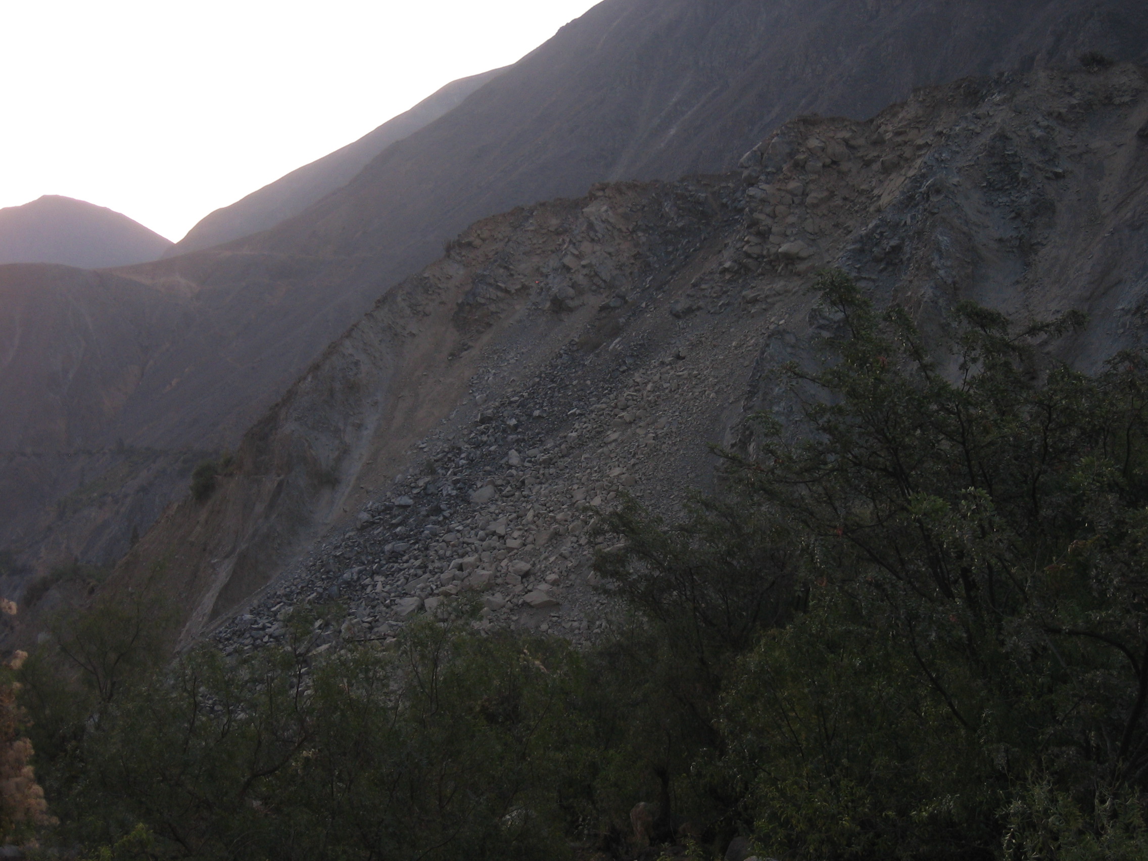
Figure 4.3
shows the upper portion of one of two adjacent rockslides occurring in natural
terrain along Highway 024A at an elevation of approximately 2250 m, and about 65
km from the fault plane. The landslide debris cone was 40 m wide at its base
and extended to an estimated height of 150 m. The rock slope consisted of
moderately fractured and jointed igneous rock. Rock slide debris, consisting of
blocks as large as 3 to 4 m in diameter, spilled into a major river below
restricting (but not blocking) the flow of water.
The disrupted
soil/rock slide shown in Figure 4.4 was encountered at an elevation of 2020 m
along Highway 024A. The closest distance to the fault plane is estimated at 65
km. A significant quantity of slide debris completely covered the road surface
after the earthquake, closing off the highway at this location. Debris was
removed to allow passage of one lane of traffic prior to the reconnaissance team
visit to the site. The slope consisted of sedimentary deposits of large (up to
1 m), subrounded igneous rocks in a silty sandy soil matrix. Other nearby stable
road cuts in this material were inclined at 60 to 65 degrees. In contrast to
many of the rockslides seen in the region, this disrupted soil/rock slide had
significantly more run out, and ultimately spilled over the road surface and
into the canyon to the right (north) of the road. It is worth noting that a
similar failure occurred in this material across the canyon in natural terrain.
References
Keefer, D. K., 1984, Landslides caused by earthquakes: Geological Society of
American Bulletin, v. 95, p. 406-421
 |
Figure 4.1 Soil avalanche
along the Pan-American Highway (8/21/07 4:53PM, S13.7102 W76.2183).
[click to enlarge] |
 |
Figure 4.2 Rockslide along
Highway 024A (08/23/07 9:42AM, S13.7106 W75.8401).
[click to
enlarge]
|
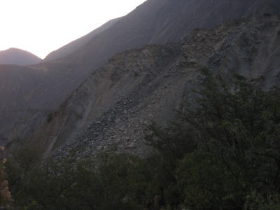 |
Figure 4.3
Rockslides in natural terrain (08/23/07 5:53PM, S13.6061 W75.3969).
[click
to enlarge]
|
 |
Figure
4.4 Disrupted soil/rock slide along Highway 024A (08/23/07 12:26PM,
S13.6103 W75.4159).
[click to enlarge] |