
[click on each picture to enlarge]
Section Outline
3.1 General Descriptions and Spatial Distribution of Liquefaction Features
3.2 Case History I: 400 m Long Slope Failure at Jahuay
3.3 Case History II: Large Lateral Spread in Canchamaná
3.4 Case History III: Foundation Failures in Tambo de Mora
3.5 Case History IV: Las Lagunas Site
3.6 Case History V: General San Martin Port in Pisco
3.1 General Descriptions and Spatial Distribution of Liquefaction Features
The August 15, 2007 Pisco Earthquake spawned a wide variety of liquefaction failures. Notable liquefaction-induced damage included a massive lateral spread extending over approximately 3 km, a 400 m long slope failure induced by liquefaction at the toe, spectacular one- to two-story building foundation failures resulting in up to 0.90 m of settlement, numerous highway embankments damaged by lateral spreading, toppling of power poles founded in liquefied soil, rupture of water and sewer lines, and disruption to port facilities. The occurrence of complete soil liquefaction at each of these sites was confirmed by either the presence of sand boils at the ground surface or wet sand ejecta in open cracks.
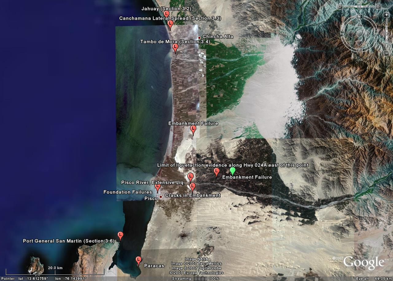
The spatial distribution of observed and reported liquefaction features along the Peru central coast ranged from Villa, just south of Lima and approximately 90 km north of the rupture plane (as defined by Ji and Zeng 2007), to Paracas in the south, approximately 24 km from the rupture plane, and Ica in the east, about 40 km from the fault plane. Our reconnaissance mission did not extend south of Paracas. The northernmost liquefaction site, in the Villa neighborhood of Lima, occurred in a swampy area. A similar swampy area located further to the north in the Ventanilla district of Lima, approximately 128 km from the rupture plane, did not show any evidence of liquefaction (Figure 3.1).
The occurrence of liquefaction along the coast is associated with artificial fills and Holocene marine, eolian and alluvial deposits composed of sands and silty sands with varying angularity and grain size. The marine deposits are stepped terraces that are successively covered by alluvial deposits as they progress inland from the coast. The alluvial deposits are associated with fans and plains from rivers discharging in the ocean. The thickness of these deposits varies from a few meters up to several hundreds of meters. The eolian deposits vary in thickness and are generally composed of dark to light gray sand ranging from coarse- to fine-grained.
|
|
Figure 3.1
Spatial distribution of liquefaction features. Picture on top shows the
overall extent of liquefaction, including one observation of no
liquefaction north of Lima in a swamp with saturated sand deposits
(green marker). The
rupture plane of Ji and Zeng (2007) is overlaid for reference. Picture
on bottom shows a zoom on the Pisco area. Note the green marker along
Highway 024A that indicates the eastern-most observation of
liquefaction-induced damage along that highway
(Background image from
Google Earth). [click on each picture to enlarge] |
|
|
3.2 Case History I: 400 m Long Slope Failure at Jahuay
A 400 m long slope failure was induced at Jahuay by liquefaction at the toe of an approximately 30 to 50 m high, steep-faced slope. The failure occured near kilometer marker 188 on the Pan American Highway just south of the toll booth plaza (approximately 40 km from the rupture plane). At this location, the highway runs right along the interface between a Holocene marine terrace deposit and the Pleistocene Cañete Formation (a conglomerate with weak- to medium-cemented sandstone, siltstone, and claystone). The failed slope material consisted of loose, non-plastic, silty sand (SM) eolian deposits that covered the stiffer Cañete Formation. The flat, swampy, marine terrace extends approximately 500 m to the coastline on the south-bound side of the highway (Figure 3.2). The slope failure was induced by liquefaction in the marine terrace deposits at the toe of the Cañete Formation. The shoulder and pavement from the north-bound lane of traffic was lifted into a near-vertical face approximately 3 m high (Figure 3.3); this is thought to have occurred as a result of the failed slope material plowing under the highway embankment. Massive amounts of failed soil were slumped between the highway and the edge of the slope over the entire 400 m length of the failure. A local man reported that the highway south of the slope failure was recently repaired and properly recompacted, and this appears to have prevented an extended failure to the south.
Sand boils were found on both sides of the highway and a man who lived just south of the slide reported water and sand squirting out of the ground approximately 1 m high during the earthquake. A large sand boil feature on the southern end of the slope failure had shrinkage cracks in some of the perimeter material, indicating the presence of plastic fines (Figure 3.4). The fines were found only on a thin layer on top of the ejecta material. Laboratory tests conducted on the ejecta from this boil indicate it classifies as clayey sand (SC) containing approximately 43% fines (11% clay-size particles) with a PI of 8 and a LL of 25. However, until further investigations are conducted at the site it will remain unclear if the fine plastic material was part of the liquefied source layer or if it was mixed in with the liquefied material on its path to the surface. It should also be noted that a sand boil on the opposite side of the road classified as poorly-graded sand (SP) with less than 3% non-plastic fines [see GSD curves here].
 |
Figure 3.2 A view of the Pan American highway at the location of the 400 m long slope failure. Marine terrace deposits are in the foreground and the Cañete Formation in the background (08/21/07 9:55AM, S13.3950 W76.1985).
|
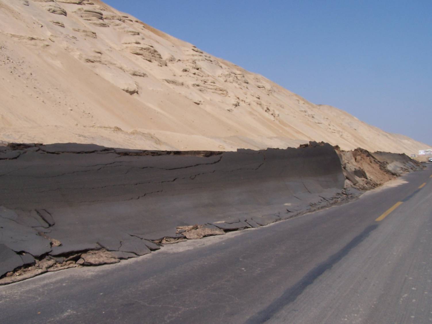 |
Figure 3.3 The shoulder and pavement from the north-bound lanes of Pan American highway were pushed into a near vertical face by a 400 m long slope failure induced by liquefaction at the toe of the slope. The coordinates for the northern-most end of the failure are S13.39184 W076.19960, while those for the southern-most end of the failure are S13.39496 W76.19785. (picture taken prior to GEER reconnaissance, courtesy of Dr. Alva Hurtado). [click to enlarge]
|
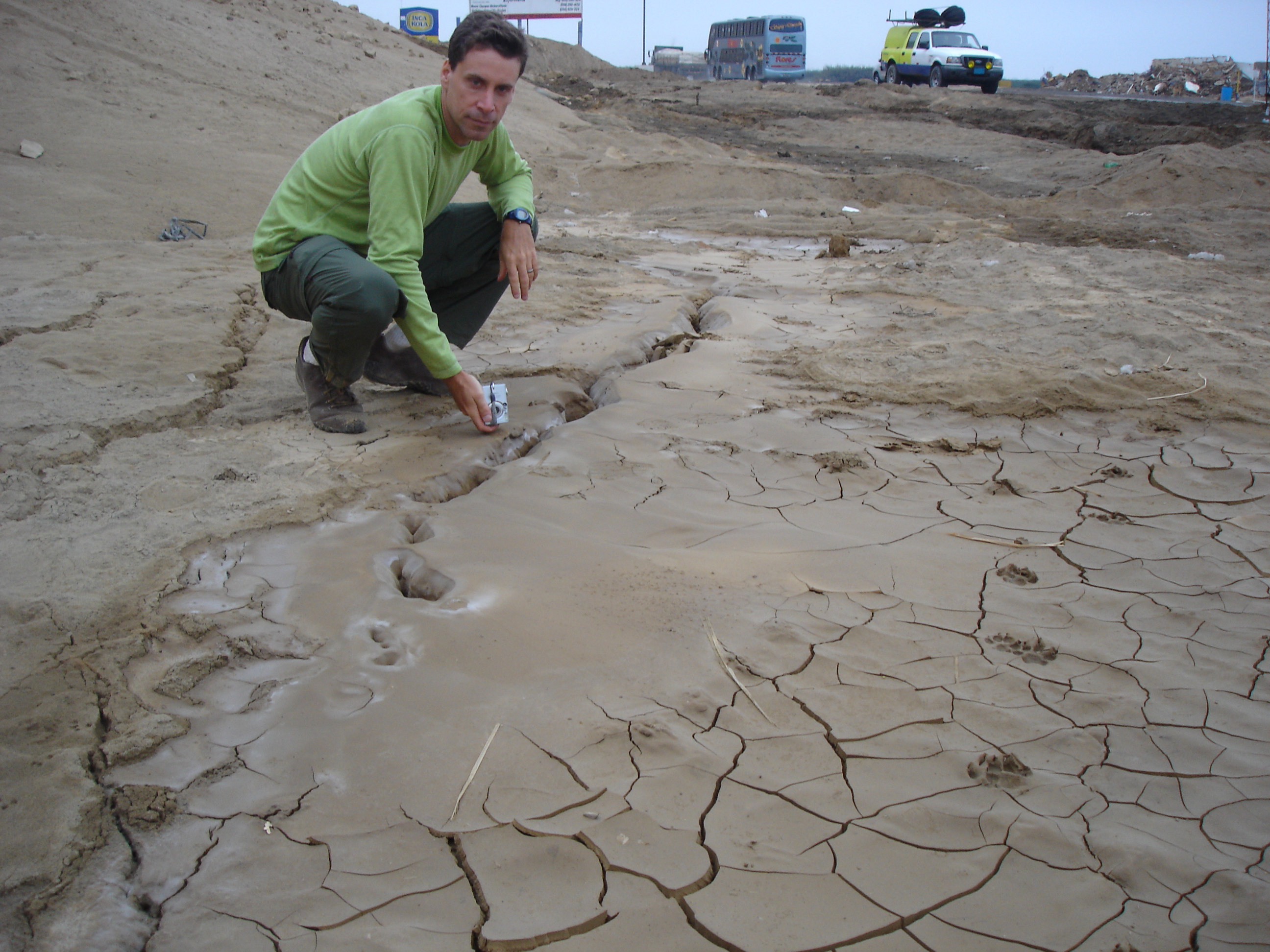 |
Figure 3.4 A large sand boil feature at the southern end of the 400 m long slope failure with shrinkage cracks in the perimeter ejecta material (08/21/07 5:25PM, S13.3950 W76.1979).
|
3.3 Case History II: Large Lateral Spread in Canchamaná
A massive liquefaction-induced seaward displacement of a marine terrace occurred in Canchamaná, 2.5 km north of Tambo de Mora. The approximate displaced area was 1 km wide by 3 km long (Figure 3.5). The eastern boundary of the lateral spread was defined by the interface between a Holocene marine terrace and the Pleistocene Cañete Formation (a conglomerate with weak- to medium-cemented sandstone, siltstone, and claystone). The southern boundary appeared to be defined by the interface of the marine terrace with a Holocene alluvial sand deposit. The northern boundary was not firmly established, but appeared to be influenced by the presence of man-made works at a bend in the Pan American highway. The lateral spread could have extended further to the north but it was not verified. The elevation of the Cañete Formation is approximately 10 to 20 m above the marine terrace. The near-surface marine terrace deposits appear to be composed of an upper layer of non-liquefiable soil (weakly cemented sand), and a lower layer of liquefiable soil (silty sand). The thickness of the upper layer tapers from approximately 6 m on the east side to a thin veneer at the beach. The depth of the groundwater table was variable at the two locations where it was measured. Both measurements were made on the eastern side of the marine terrace near the Cañete Formation. In an existing well located approximately at the center (north-to-south) of the displaced area, the ground water was measured at 5.2 m deep, and in an open pit approximately 0.70 km north of this well, the ground water table was measured at 2.0 m deep. The westward slope of the marine terrace surface was approximately 1.6 to 2.1 %.
A clear vertical offset (scarp) of variable magnitude was observed along much of the geological interface between the marine terrace and the Cañete Formation. A maximum vertical displacement of approximately 3 m was measured where a local dirt road links Canchamaná with La Victoria town (Figure 3.6). In addition to the main scarp at the interface, numerous extensional ground cracks developed across the marine terrace parallel to the coastline. In general, the cracks were largest (both in terms of horizontal and vertical displacement) near the scarp and became smaller towards the coastline. Some crack widths were as large as 1 m and sand ejecta was found inside many of them (Figure 3.7). In some areas the cracks also ran perpendicular to the beach or in a circular pattern, indicating the effect of topography.
At the northern-most end of the failure, an approximately 8.0 m tall artificial fill embankment for the Pan American highway had been built across a natural drainage feature. Liquefaction and lateral spreading of the marine terrace induced failure of the embankment fill and sheared three concrete box culverts running through the embankment (Figure 3.8). Sand boils with diameters as large as 2 m were encountered near the base of this embankment (Figure 3.9). It is interesting to note that the sand boil shown in Figure 3.9 has shrinkage cracks around its perimeter similar to the one shown in Figure 3.4. These boils were both found at the base of the Cañete Formation and are only 2 km apart. It is highly likely that the same liquefiable material induced both failures as additional sand boils and small scarps were noted in between these locations.
At present it is very difficult to estimate the total lateral displacement of the marine terrace because it occurred over such a massive area. However, local fishermen showed us traces on the beach of the sea level before and after the event, suggesting that the water line moved about 25 m westward. This measure is not an estimate of the horizontal displacement of the lateral spread, but it is believed that lateral spread contributed to this change in the landscape. A bulge along the beach was also observed, indicating that this could have contributed to the movement of the coastline. Figure 3.10 shows a sketch of the observed massive displacement of the marine terrace.
 |
Figure 3.5 Approximate area of a massive seaward lateral displacement of the marine terrace in Canchamaná. The boundary of the mobilized area on the north is uncertain and could possibly extend further (Background image from Google Earth). |
 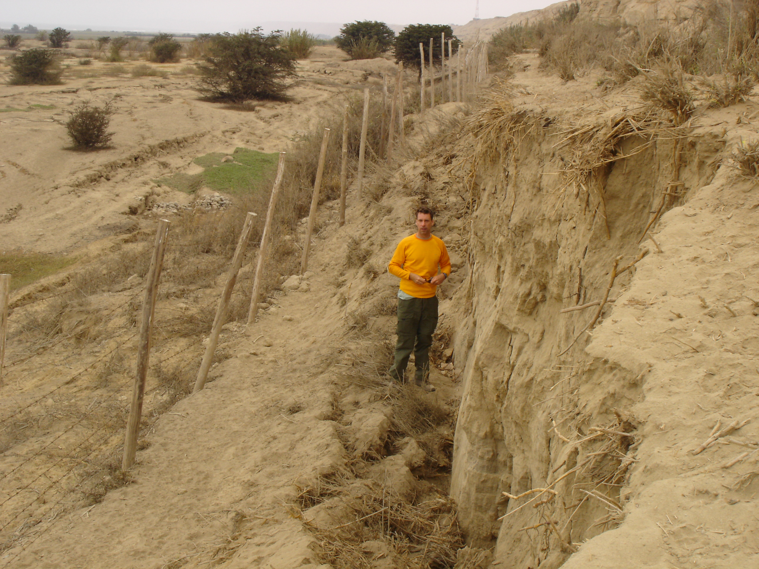 |
Figure 3.6 Maximum vertical offset of approximately 3.0 m along the
interface between the marine terrace deposit and the
Cañete Formation (08/24/07 12:54PM[top]
and 1:03PM[bottom],S13.4318 W76.1819). [click each figure to enlarge]
|
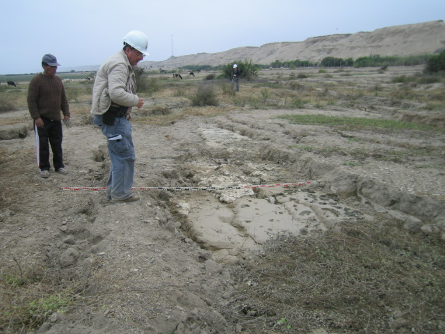 |
Figure 3.7 Ground cracks and ejecta in the marine terrace deposits. The
Cañete formation, indicating the eastern edge of the failure mass, is
seen in the background (8/23/07 3:04PM, S13.4348 W76.1836).
|
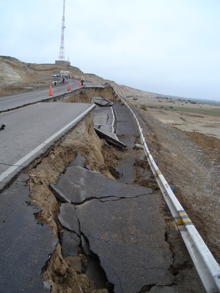 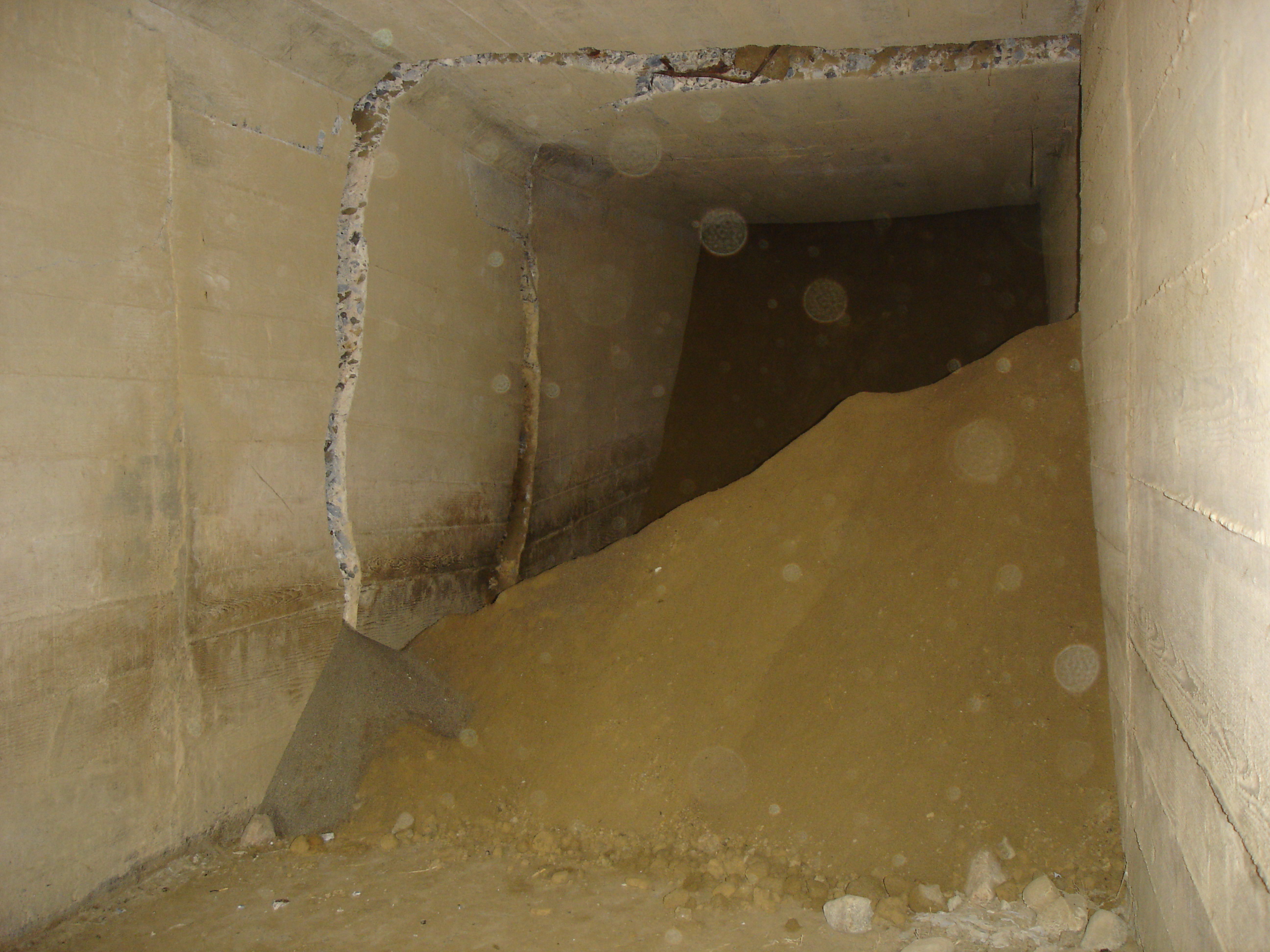 |
Figure 3.8 Liquefaction and lateral spreading of the marine terrace
induced failure of the Pan American highway embankment fill and sheared
three concrete box culverts running through the embankment (08/18/07
10:26AM[left]
and 08/24/07 2:44PM[right],S13.41322
W076.18927). [click each figure to enlarge] |
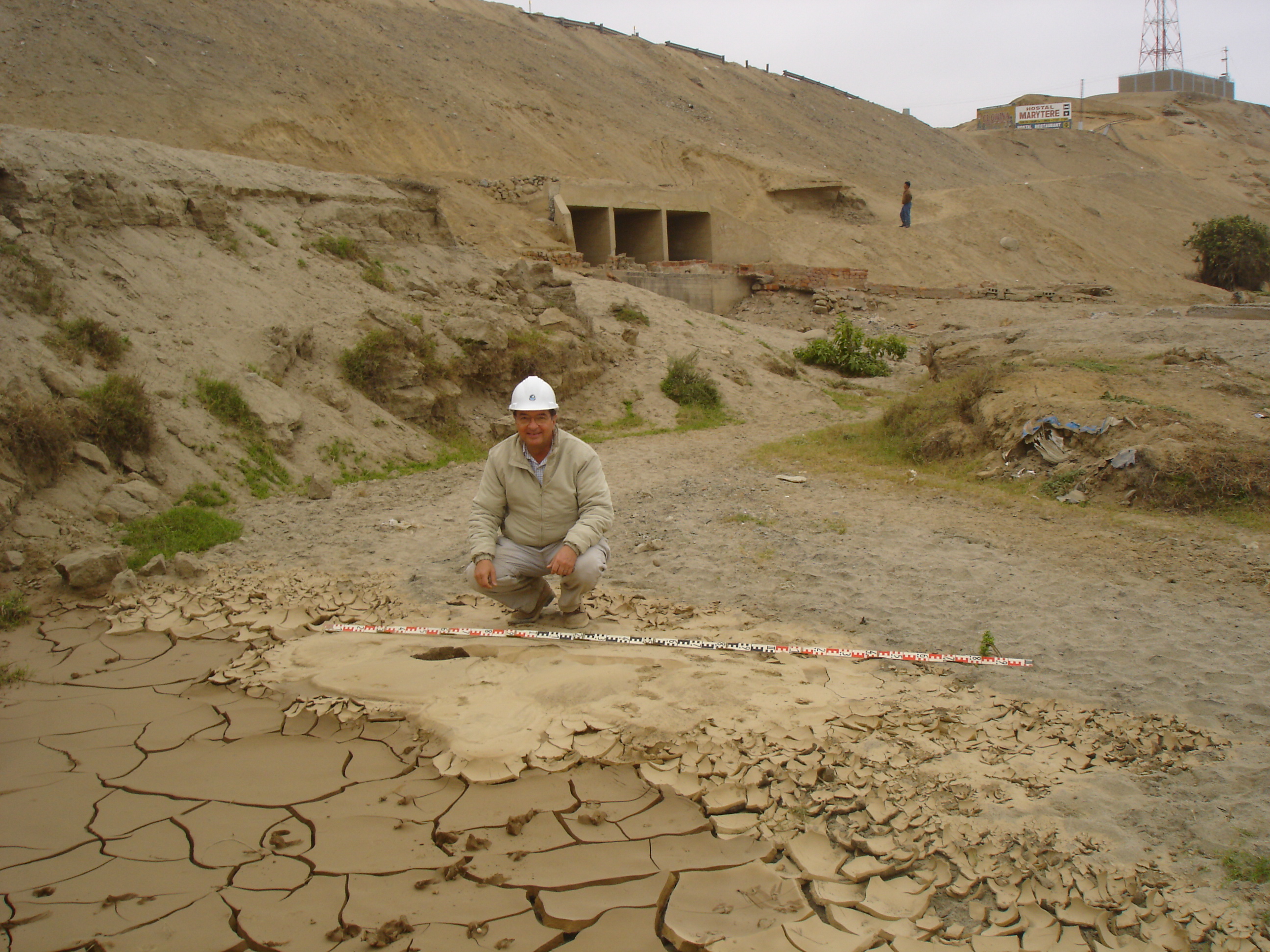 |
Figure 3.9 A large sand boil at the base of the Pan American
highway embankment failure. Note the three
concrete box culverts running through the embankment that were sheared
during the failure (see Figure 3.8). Also notice the shrinkage cracks
in the perimeter ejecta material (08/24/07 2:47PM, S13.41307 W76.18960).
|
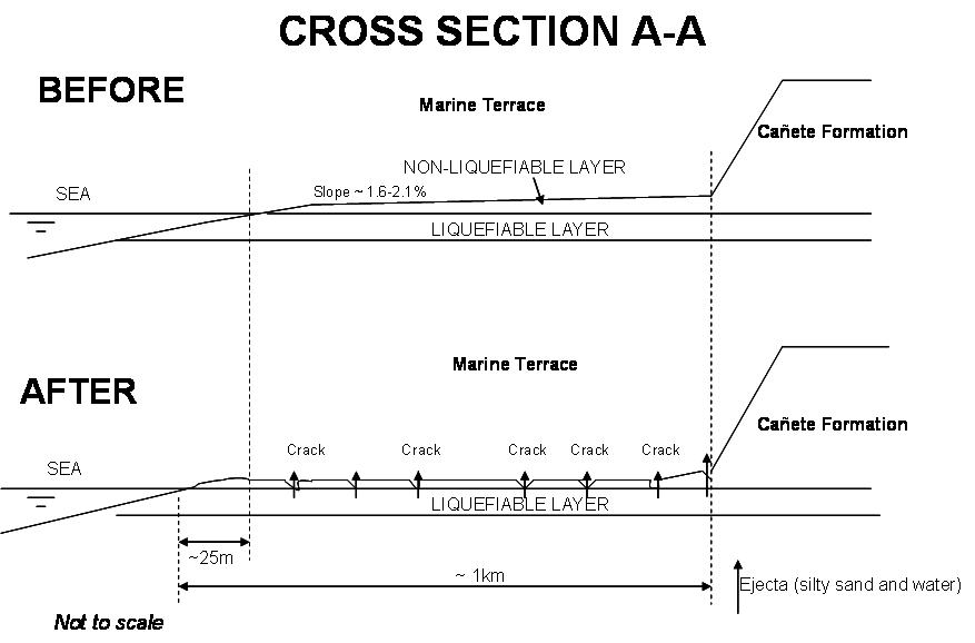 |
Figure 3.10 Sketch of the massive displacement of the marine terrace at
Canchamaná at Cross Section A-A from Figure 3.5.
|
3.4 Case History III: Foundation Failures in Tambo de Mora
Spectacular occurrences of liquefaction-induced foundation failures were documented in the northwest portion of Tambo de Mora approximately 0.5 km from the coastline and 38 km from the rupture plane. Tambo de Mora is located on Holocene alluvial and eolian deposits and has a shallow ground water table. While widespread evidence of soil liquefaction (minor settlement and sand ejecta) was present throughout much of the northwest portion of the city, particularly heavy damage (excessive settlement) was observed in one- to two-story buildings along a 300 m stretch of Alfonso Ugarte Street. Along this stretch of road, nearly every building settled substantially (0.3 m plus), with multiple buildings settling between 0.7 and 0.9 m (Figures 3.11 and 3.12). Large quantities of ejecta was observed in cracks that had developed in the road and inside of buildings whose unreinforced slab-on-grade floors had been broken apart and heaved–up into their interiors (Figures 3.13 and 3.14). In most cases, ejecta was gray, non-plastic, poorly-graded sand (SP) to silty-sand (SM). One exception was a plastic silt (ML, LL = 48) found in the interior of a house [click here to see GSD of ejecta]. The depth to the water table along the road was measured at 0.3 m during our visit a week after the earthquake. However, locals reported that the water table existed at a depth between 0.5 to 1.0 m prior to the earthquake. These same residents reported water and sand shooting more than 1.0 m out of the ground beginning with the second strong phase of the earthquake.
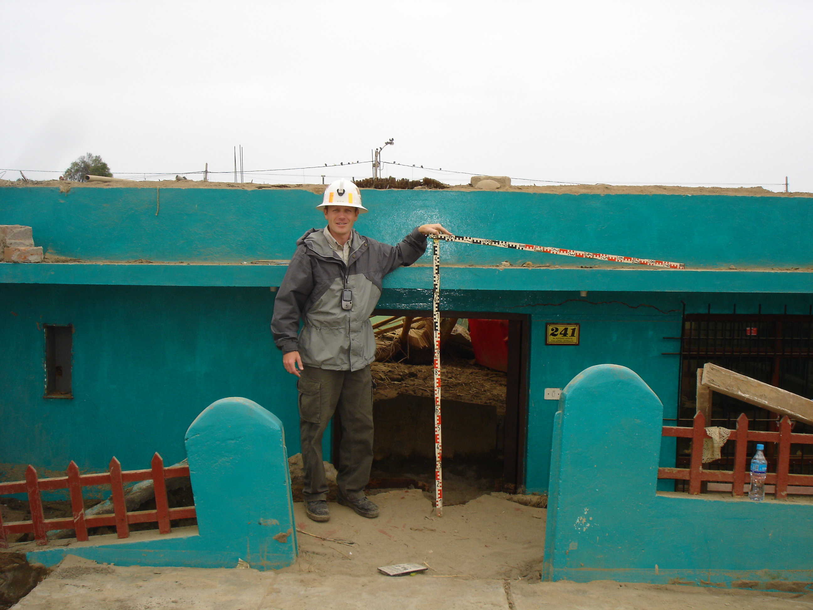 |
Figure 3.11 Approximately 0.9 m of liquefaction-induced settlement at a
one-story residence located at 241 Alfonso Ugarte Street in Tambo de
Mora (08/24/07 12:19PM, S13.45682 W76.18277).
|
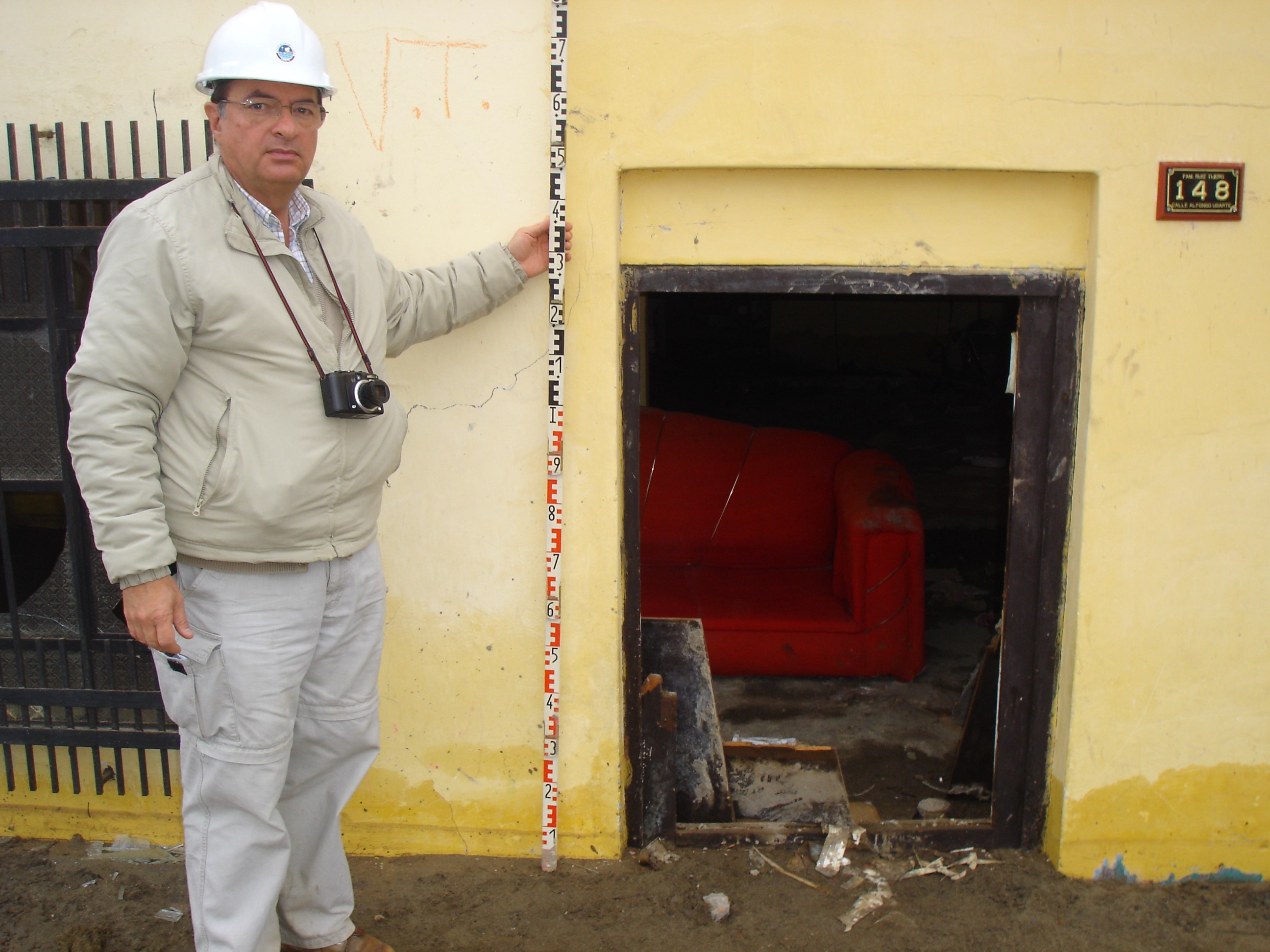 |
Figure 3.12 Approximately 0.8 m of liquefaction-induced settlement at
a one-story residence located at 148 Alfonso Ugarte Street in Tambo de
Mora (08/24/07 9:35AM, S13.45682 W76.18277).
|
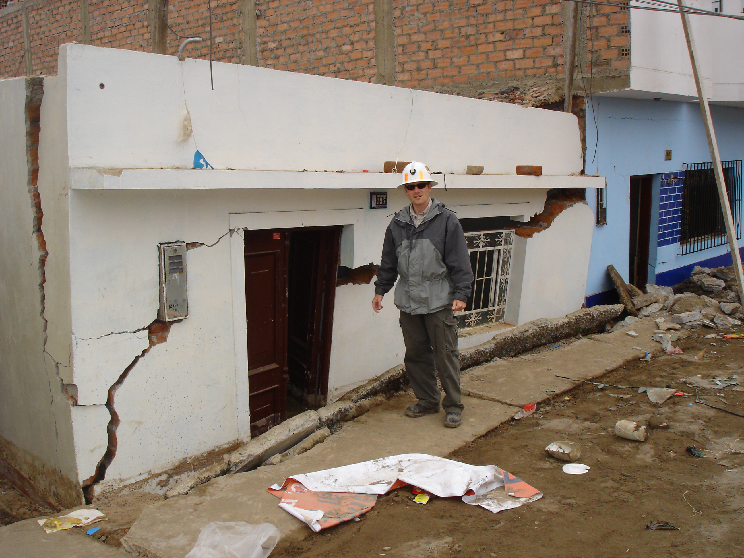 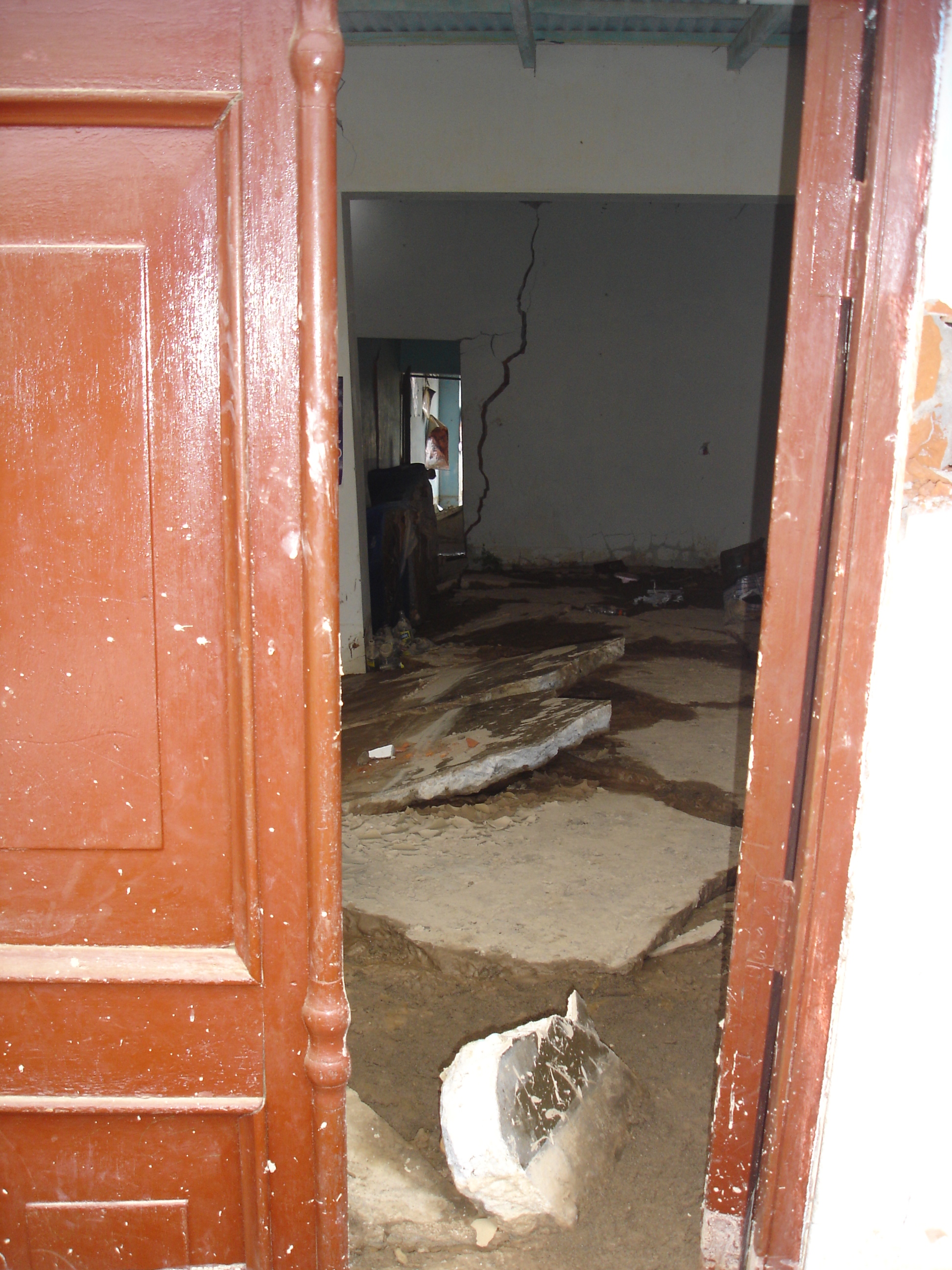 |
Figure 3.13 Approximately 0.7 m of liquefaction-induced settlement at
a one-story residence located at 197 Alfonso Ugarte Street in Tambo de
Mora . Both an outside- and inside-view of the
home are shown
(08/22/07 11:57AM, S13.45577 W76.18295). [click each figure to enlarge]
|
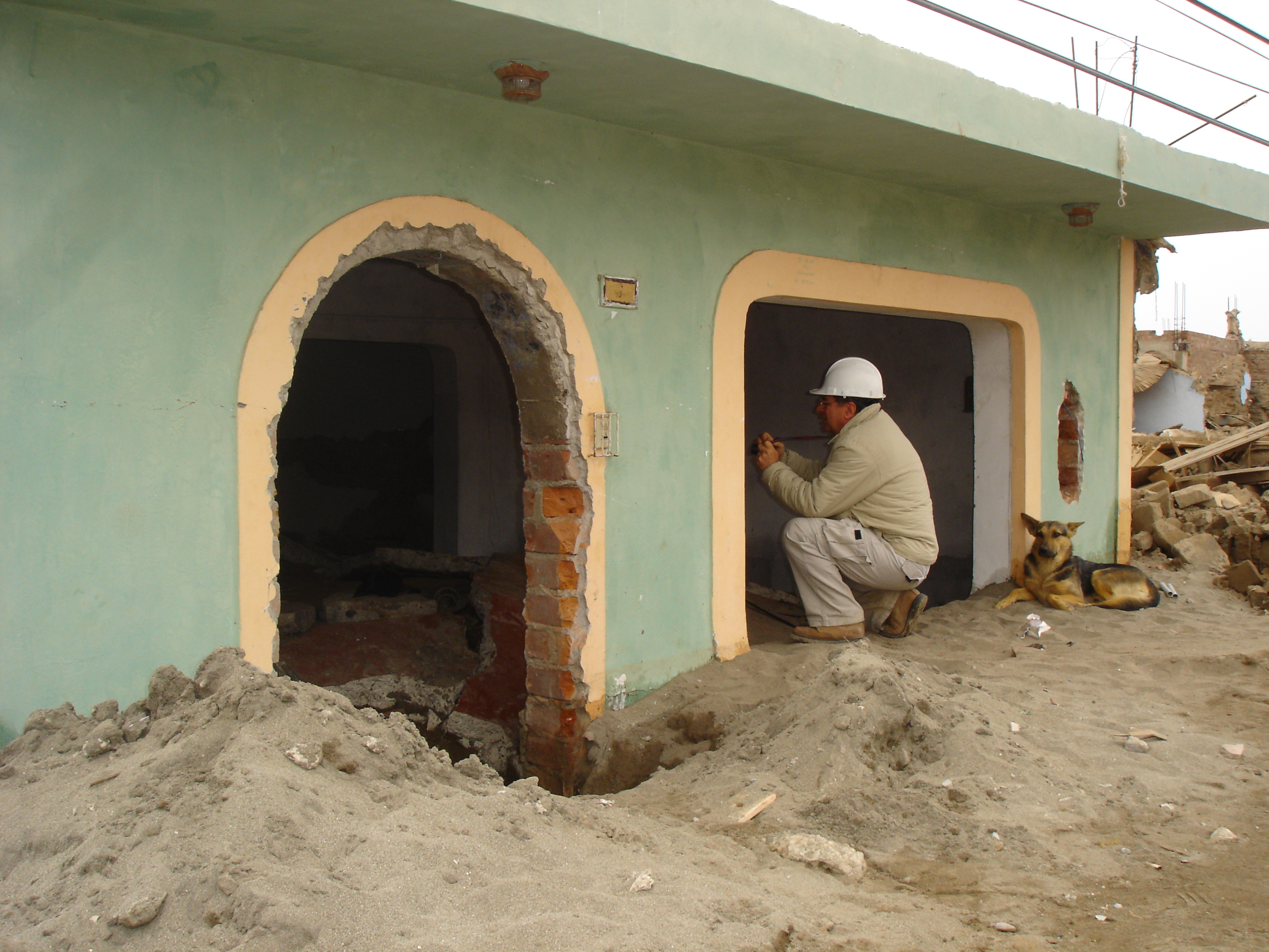 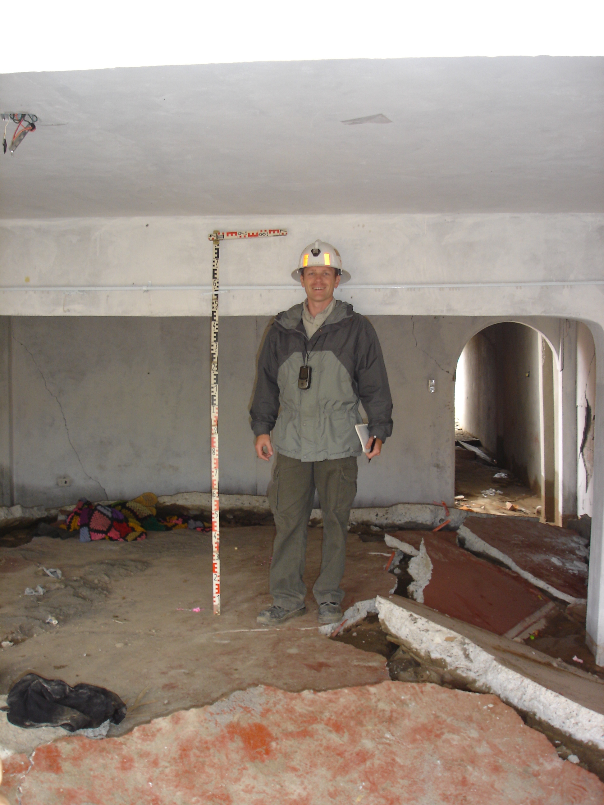 |
Figure 3.14 Approximately 0.7 m of liquefaction-induced settlement at
a one-story residence (house number unknown) on Alfonso Ugarte Street in
Tambo de Mora. Both an outside- and inside-view
of the home are shown
(08/24/07 12:12PM, S13.45526 W76.18298).
[click each figure to enlarge]
|
3.5 Case History IV: Las Lagunas Site
Las Lagunas is a beach housing complex 71 km south of Lima and approximately 51 km from the rupture plane. The area is located in a recent Holocene marine terrace deposit. The complex consists of one- or two-story houses constructed out of brick masonry confined by reinforced concrete columns and beams. Structural damage varied from none to severe and was closely correlated to the degree of foundation settlement and lateral displacement associated with soil liquefaction. Many of the houses are built around manmade freshwater lagoons that were formed by dredging sand and letting the water rise to the natural elevation of the ground water table. The banks of the lagoons were grass-covered slopes with an estimated slope of 1.5H to 1V. There was widespread evidence of lateral displacement of houses towards either the lagoons or the ocean, with displacements ranging from a few centimeters for some ocean-side houses to a case involving 3.9 m of movement towards an inland lagoon (Figure 3.15 and 3.16). Some houses also settled as much as 0.2 m. At least one lateral spread was also observed on the banks of a lagoon where there were no nearby buildings (Figure 3.17). Additionally, many houses did not show any evidence of movement and performed well in the earthquake, even when located near the open face of a lagoon. In the limited time of our visit, no clear pattern as to the spatial distribution of liquefaction damage within the subdivision could be deciphered. Sand ejecta was present at various places, mainly along cracks in the ground. The ejecta was gray, fine, uniform sand with some non-plastic silt.
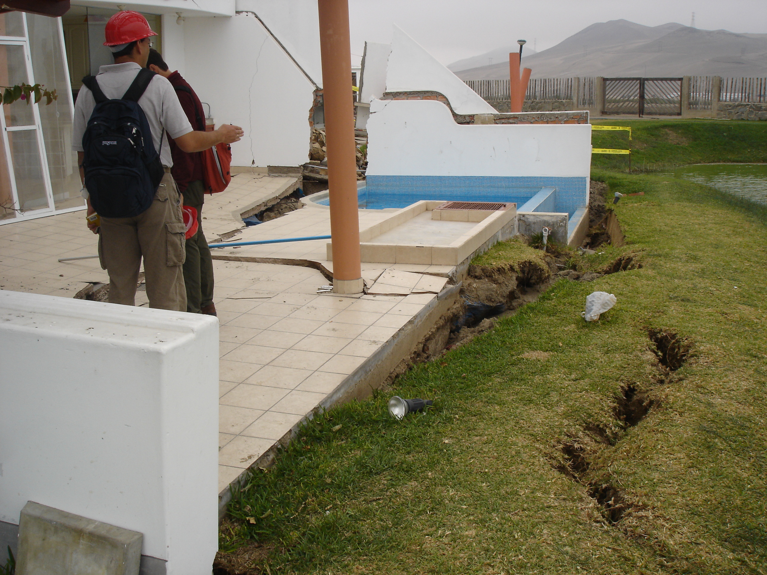 |
Figure 3.15. Lateral displacement of the lagoon slope with respect to a pool (measured to be approximately 0.9m). Displacement at this location is along a shallow failure surface located underneath the topsoil (08/21/07 2:07PM, S12.57739 W76.70338). |
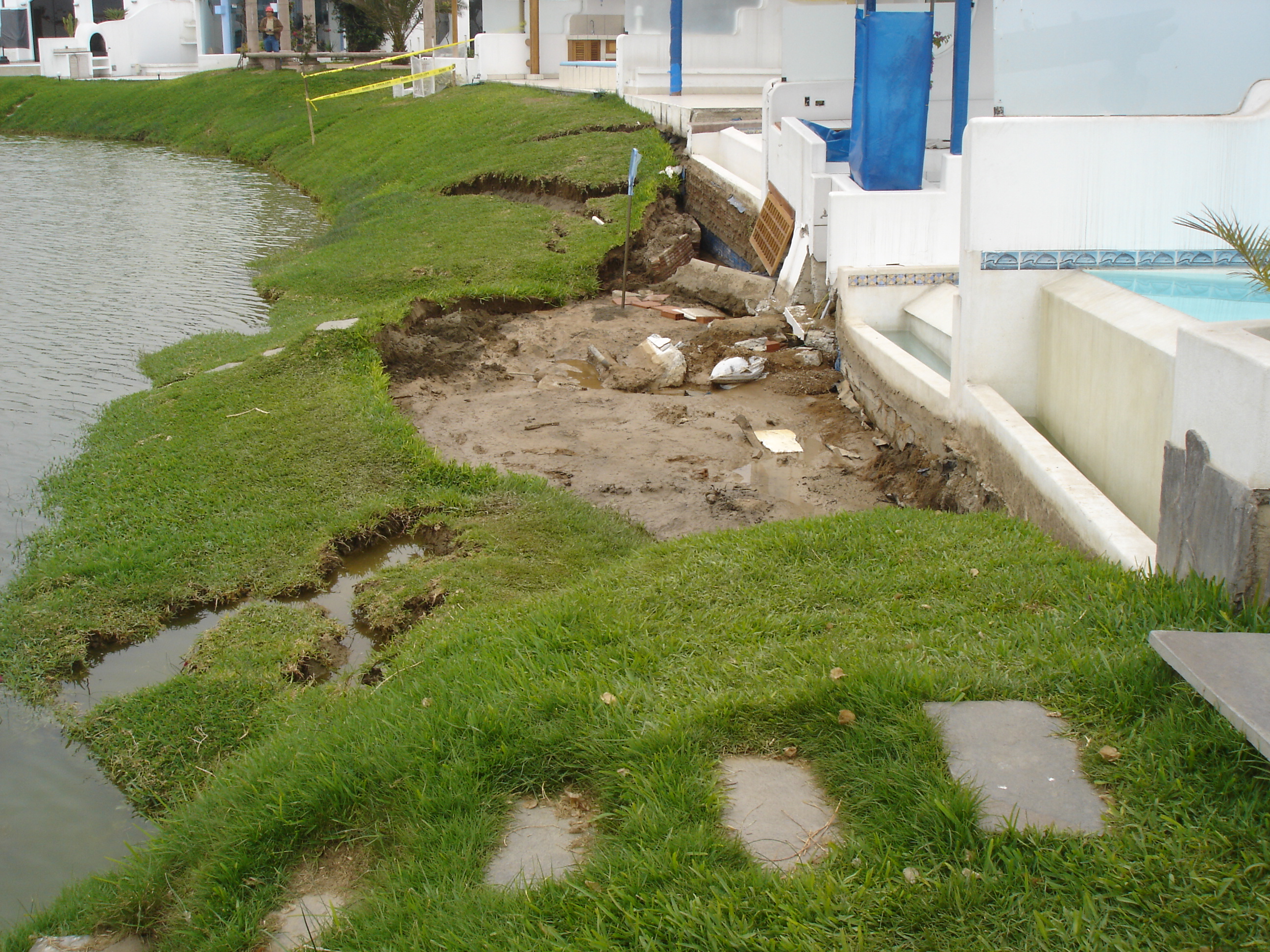 |
Figure 3.16. Lateral spread with a displacement of 3.9 m. The house located in front of this lateral spread suffered considerable damage due to differential settlements. The picture is taken from a house that is undamaged and where no lateral displacements were observed (08/21/07 2:18PM, S12.57672 W76.70358). |
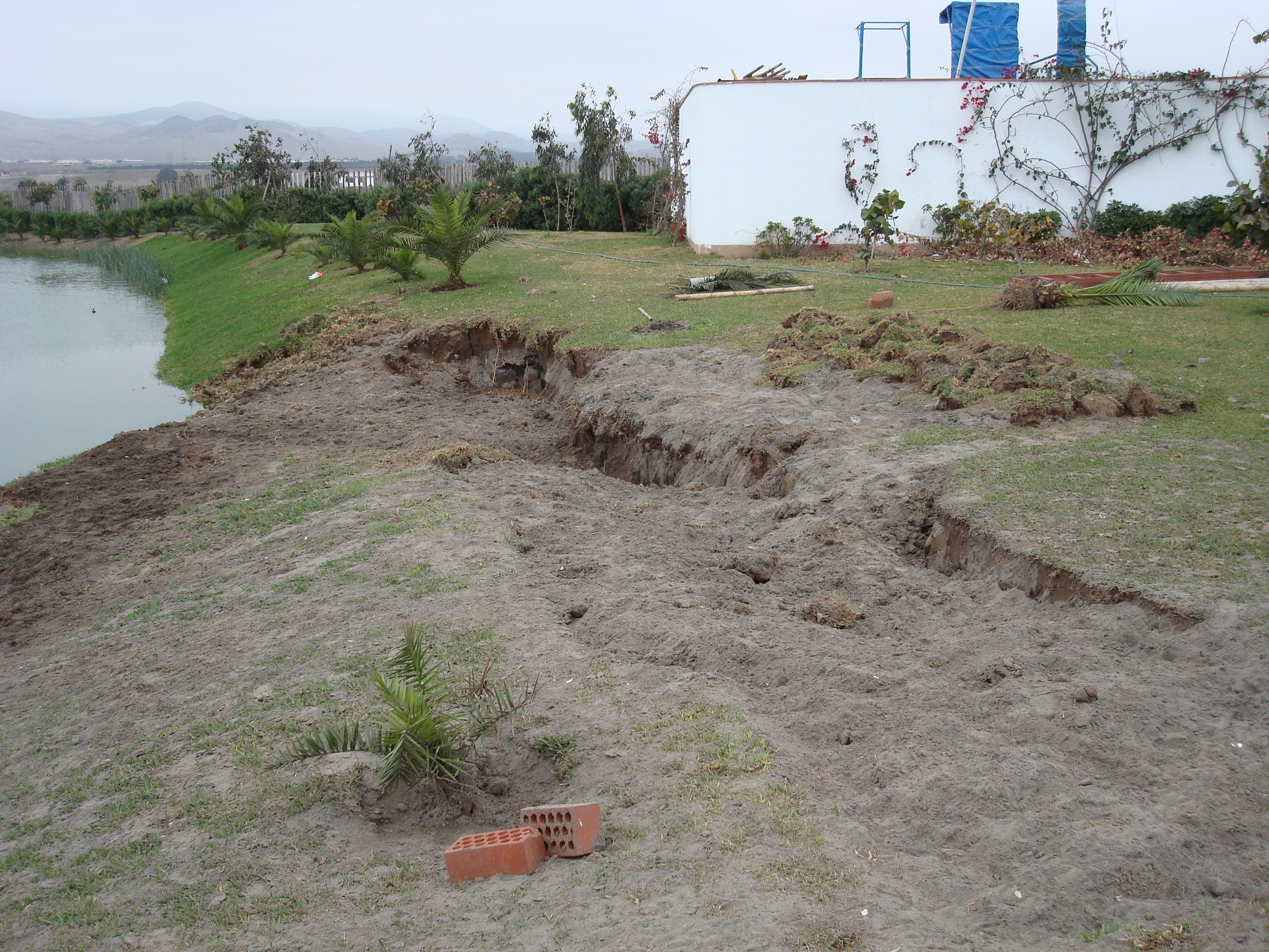 |
Figure 3.17. Lateral spread in a lagoon slope. The feature is 17 m long and approximately 5 m wide. Horizontal displacements were estimated in the order of 1 m. Cracks running parallel to the crest of the slide were observed as far back as 5 m from the crest (08/22/07 1:43PM, S12.57817 W76.70433) |
3.6 Case History V: General San Martin Port in Pisco
The General San Martin Port was inaugurated in 1970 and operates with ships as heavy as 25,000 tons of dead weight. It is located in Punta Pejerrey, Pisco Beach, approximately 30 km from the fault. The port is surrounded by granite porfids (intrusive rocks), which are part of the San Nicolas Batholite. The granite porfids have a fine to coarse matrix with colors ranging from pink to dark brownish red. Port facilities were constructed on reclaimed land as shown in Figure 3.18. The wharf has a reinforced concrete deck that is supported by 780 circular steel pipe piles. The reclaimed land area of the port settled over the years resulting in differential movement between the pile-supported buildings and the surrounding soil. The typical solution to this problem was to place more fill to level the surrounding reclaimed ground surface. The earthquake induced liquefaction in the reclaimed land, as evidenced by sand boils (Figure 3.19) and lateral spreading with significant cracks as wide as 0.25 m and vertical offsets as large as 0.8 m (Figure 3.20). The pile-supported deck appeared slightly inclined seaward, and horizontal offsets in the deck joints were as large as 0.50 m (Figure 3.21). Ground cracking developed parallel to the deck on the reclaimed land area and was most severe near the waterfront (Figure 3.22). A pipeline that ran across the port inside of a concrete box was not damaged in the earthquake despite the fact that the surrounding ground settled substantially (Figure 3.23). It is presumed that the concrete box was supported on piles. No cracks were observed in native ground around the pier.
 |
Figure 3.18 Pre-earthquake view of General San Martin Port, Pisco Beach
with intrusive rock in the foreground and reclaimed land in the
background.
|
 |
Figure 3.19 Sand ejecta in General San Martin Port and differential
settlement between fill and pile-supported wharf (08/22/07 10:35AM, S13.7965 W76.2875).
|
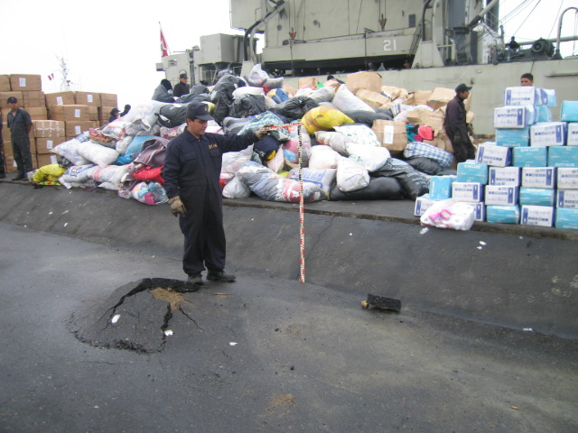 |
Figure 3.20 Vertical displacements as large as 0.8 m were observed
between the pile-supported wharf and the reclaimed backfill. The bulge
appears to be a pile that was buried in the fill. Although the port was
heavily damaged, it had enough functionality to receive relief for
earthquake victims (08/22/07 9:08AM, S13.7955 W76.2865).
|
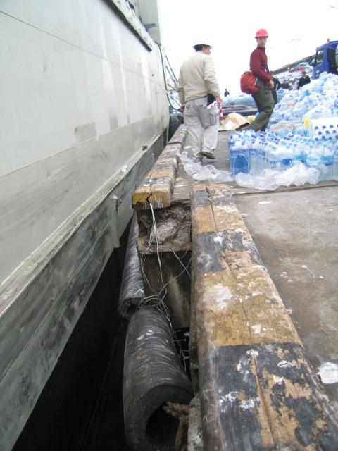 |
Figure 3.21 Permanent lateral displacement of the wharf deck at one joint.
Measured displacement of 0.50 m (08/22/07 10:00AM)
|
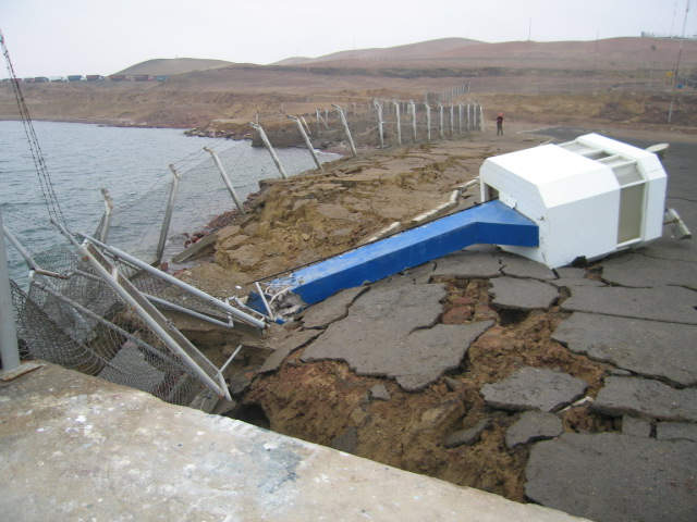 |
Figure 3.22 Extensive cracking in the waterfront fill at the port
(08/22/07 9:20AM, S13.7971 W76.2888).
|
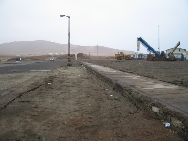 |
Figure 3.23 Ground settled around a concrete box containing a pipeline.
The pipeline did not suffer any damage, and the concrete box only
displaced a few centimeters at the joints (08/22/07 10:48AM, S13.7679 W76.2888).
|