Chapter One: Introduction
The January 17, 1995, Hyogoken-Nanbu Earthquake is the most damaging earthquake to have struck Japan since the great Kanto earthquake destroyed large areas of Tokyo and Yokohama and killed approximately 140,000 people (mostly by fire) in 1923. Part of the reason for the great devastation was the location of the epicenter of the earthquake, at the tip of Awaji Island, within 20 km of the city of Kobe in the Hyogo prefecture (see Figure 1.1). The city of Kobe houses about 1.5 million people, and it is a part of a continuous, densely developed urban area which extends from west of Kobe eastward to Osaka and has a population of more than 4 million inhabitants (AIJ, 1995; Figure 1.2). As of March 31, 1995, the toll from the earthquake in Kobe has reached over 5,500 dead and over 26,000 injured. More than 200,000 houses, about 10% of all houses in the Hyogo prefecture, were damaged, including more than 80,000 collapsed, 70,000 severely damaged, and 7000 consumed by fire (AIJ, 1995). Current estimates of losses in Kobe are about 20 trillion yen (200 billion dollars), one order of magnitude larger than that from the January 17, 1994, Northridge Earthquake.
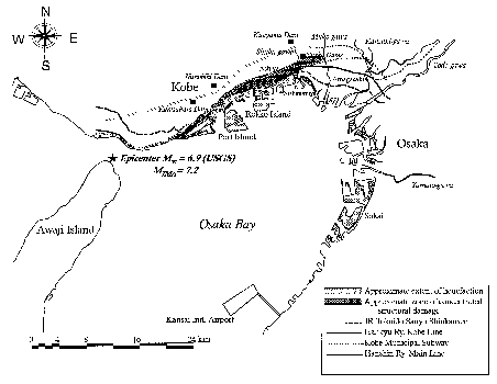 Figure 1.1: Schematic map of the Kobe-Osaka region, showing the location of the epicenter of the Hyogoken-Nanbu earthquake and major points of interest, including the approximate extent of the areas of severe structural damage and liquefaction.
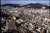 Figure 1.2: Aerial view of the Kobe metropolitan region showing the density of urban and commercial development.
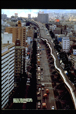
The strategic location of Kobe, at a point where the proximity of the mountains and the sea constricts the transportation corridor, also meant that the damage to the transportation network, as exemplified by the now famous picture of the collapsed section of the Hanshin Expressway (Figure 1.3), had a large economic impact extending well beyond the immediately affected area. Before the earthquake, Kobe was Japan's busiest and the second largest port after Yokohama. It was also the largest Japanese port for foreign trade cargo, mostly containerized, with over 53 million metric tons of foreign trade in 1990. It was the fourth largest container cargo port in the world. About 39% of the city's gross industrial product was derived from port related industries, accounting for more than 17% of the city work force. The earthquake damage caused essentially total shutdown of all facilities in the port area for several weeks following the earthquake.
 Figure 1.3: Collapsed section of the Hanshin Expressway (reproduce from Asahigraph, 1995).
The purpose of this report is to provide an overview of the principal geotechnical aspects of the earthquake. To this end, the seismological aspects of the Kobe earthquake are presented in Chapter 2. The regional seismicity and tectonics, including local geology, are reviewed first, followed by a discussion of the source characteristics of the earthquake. Observations of surface rupture are presented, and recorded strong ground motions and site response issues are examined. The recorded strong motions are compared with empirical attenuation relationships based on primarily California data, and important implications for US practice are drawn.
Liquefaction and liquefaction related effects are described in Chapter 3. The extent of liquefaction provided a unique opportunity to asses the performance of various types of foundations under conditions of loss of bearing capacity and lateral support, and subjected to lateral spreading. The performance of improved ground is reviewed in Chapter 4. The observation of the behavior of dams and levees are presented in Chapter 5. The damage to lifeline systems is described in Chapter 6, and other geotechnical aspects of the earthquake damage, including the performance of slopes, structural fills, mechanically stabilized slopes, and landfills, are presented in Chapter 7.
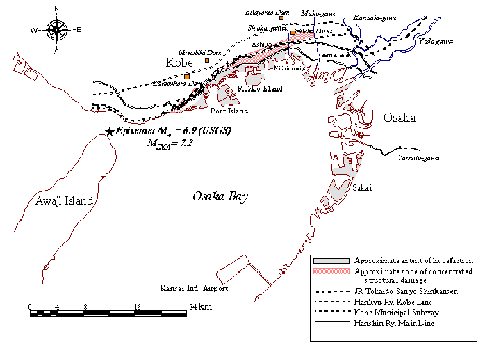 Figure 1.1: Schematic map of the Kobe-Osaka region, showing the location of the epicenter of the Hyogoken-Nanbu earthquake and major points of interest, including the approximate extent of the areas of severe structural damage and liquefaction.
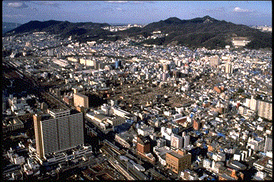 Figure 1.2: Aerial view of the Kobe metropolitan region showing the density of urban and commercial development.