2.5 Surface Rupture
The earthquake produced surface rupture with an average horizontal displacement of 1 to 1.5 m and a maximum recorded horizontal displacement of 1.7 m on the Nojima fault, which runs along the northwest shore of Awaji Island (Nakata, personal communication, 1995). Figure 2.7 illustrates the general characteristics of the topography along the Nojima fault and the surface expression of the predominantly strike-slip faulting. A close-up view of a scarp of the Nojima fault, which showed both vertical and horizontal offsets (at one spot, these offsets were measured to be approximately 1.2 m right-lateral and 15 cm dip-slip (east side up), respectively) is shown in Figure 2.8. The house shown in the background in Figure 2.8 was nearly offset by the surface fault rupture, but it appeared to be only slightly damaged by the ground shaking. Just to the north of this area, the Nojima fault cut across a number of wet rice paddies before continuing along the base of the hills formed from the uplift of Pre-Miocene bedrock. It was more difficult to see the surface expression of the faulting in the wet rice paddies, and in areas the faulting was expressed as en echelon shears with minor offsets across them. At numerous locations the observed surface expression of the fault was fairly narrow (<5 m wide), and this is consistent with the style of faulting (fairly linear strike slip faulting through shallow soil deposits overlying the bedrock). However at a few locations, the ground breakage zone was noticeably wider. For example, at the northern end of the surface expression of the Nojima fault where it travels offshore of Awaji Island, about 1 m of horizontal displacement was spread across a zone roughly 50 m wide, which contained several ground cracks. Most of the offset was concentrated on three or four cracks within the middle of this zone. Vertical displacement across the observed surface rupture of the Nojima fault varied considerably with an average vertical displacement of 0.5 to 1 m (east side up) and a maximum vertical displacement of 1.3 m (east side up). At the southern end of the exposed ground rupture, the observed vertical displacement decreased and was actually in the opposite sense with the west side moving up slightly (<0.2 m) with respect to the east side.
Marine seismic surveys have found a 300 meter long offshore extension of this rupture (Japan Maritime Safety Agency). This segment of the fault ran between the main towers of the Akashi Kaikyo suspension bridge, which is under construction, offsetting the southern tower 1.1 m in a right lateral sense with respect to the northern tower (Fig. 2.9). The surveys also found two fault rupture segments that span a length of about 7 km in the region offshore from the northeast tip of Awaji island, parallel to the Nojima fault but offset from it by about 5 km. Near the onshore projection of these underwater rupture segments, a releveling survey after the earthquake found a change in elevation of 26 cm over a distance of 6 km between Tarumi and Suma Wards in western Kobe. Ground surface deformations, which are possibly associated with surface ruptures, have been identified east of Kobe in the Takarazuka area on a number of active fault strands just south of the Arima-Takatsuki fault zone (see Figure 2.10, M. Seo and Y. Yoshimi, personal communication, 1995). Aerial reconnaissance identified possible right lateral surface rupture expressions to the southwest of this area across the Muko River along the general trend of the strike of identified active faults in the area. A close-up view of a tennis court which shows ground cracks with noticeable right lateral offsets is shown in Figure 2.11. This feature has not been field-checked, and there are numerous fills and buried stream deposits in the area, so ground cracking may have resulted from phenomena other than faulting. However, field data provided by M. Seo and general observations of damage in the Takarazuka area suggest that there may be a correlation between some concentrations of heavily damaged areas (both buildings and transportation systems) and active fault segments that expressed some ground movement during the Kobe Earthquake. Additional study is warranted to confirm these preliminary observations.
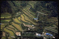 Figure 2.7: Aerial view of northwest shore of Awaji Island showing the surface rupture of the faulting. Note the surface rupture that cuts across the middle of the picture.
 Figure 2.8: Scarp of the Nojima fault on Awaji Island showing both vertical and horizontal offset. Source: Newsweek, February 1, 1995, Japan edition.
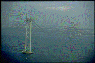 Figure 2.9: Kaikyo suspension bridge. The tower in the foreground was offset 1.1m RL with respect to the tower to the north. The distance between the towers is 2000 m.
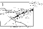 Figure 2.10: Map of the Takarazuka area showing locations of ground surface deformations, active faults, and associated damage. Source: M. Seo of Kokusai Kogyo Co., Ltd.
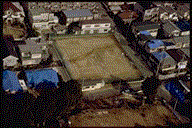 Figure 2.11: Aerial view of possible right lateral surface rupture in tennis court in area just southwest of Takarazuka.
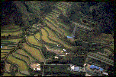 Figure 2.7: Aerial view of northwest shore of Awaji Island showing the surface rupture of the faulting. Note the surface rupture that cuts across the middle of the picture.
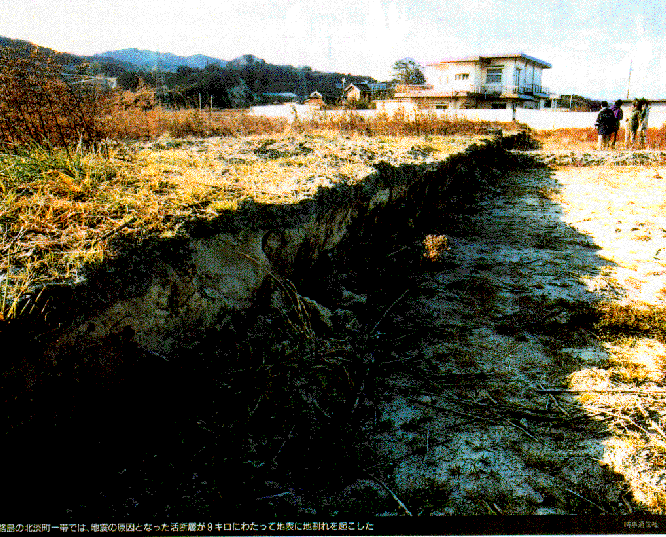 Figure 2.8: Scarp of the Nojima fault on Awaji Island showing both vertical and horizontal offset. Source: Newsweek, February 1, 1995, Japan edition.
 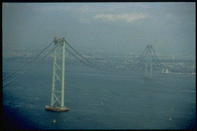 Figure 2.9: Kaikyo suspension bridge. The tower in the foreground was offset 1.1m RL with respect to the tower to the north. The distance between the towers is 2000 m.
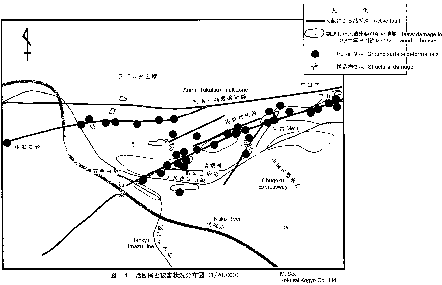 Figure 2.10: Map of the Takarazuka area showing locations of ground surface deformations, active faults, and associated damage. Source: M. Seo of Kokusai Kogyo Co., Ltd.
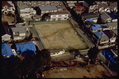 Figure 2.11: Aerial view of possible right lateral surface rupture in tennis court in area just southwest of Takarazuka.