2.6 Strong Ground Motions
Strong ground motions were recorded by several organizations, including the Committee on Earthquake Observation and Research in the Kansai Area, Japan Rail, Osaka Gas, JMA, Hankyu Railroads, Japan Highways, Building Research Institute, and Port and Harbor Research Institute. The ground motions varied significantly in the epicentral region, indicating a complex interaction of important effects such as directivity, local site conditions, and topography. Peak ground accelerations as large as 0.8 g were recorded in the near-fault region on alluvial sites in Kobe and Nishinomiya. The recordings at near-field rock sites typically had significantly lower magnitudes of peak ground acceleration (i.e. around 0.3 g). The vertical peak ground accelerations were generally about two-thirds as large as the horizontal accelerations in the near-field, and significantly lower than this at more distant alluvial sites. Velocity waveforms recorded at a number of strong motion stations in the Osaka Bay area are shown in Figure 2.12 along with their respective locations. Note the difference in the motions recorded in the near-field (i.e. at KMO (Kobe) and KBU (Kobe University)) from those recorded at more distant stations (e.g. FKS (Fukushima) and YAE). The near-field motions contain brief, intense pulses; whereas, the more distant records have significantly longer duration of strong shaking with dominant low frequency periodic motions resulting from surface waves or site resonance.
 Figure 2.12: Velocity waveforms (horizontal east-west component) recorded by the Kinki Strong Motion Observation Network. Source: GeoResearch Institute, 1995.
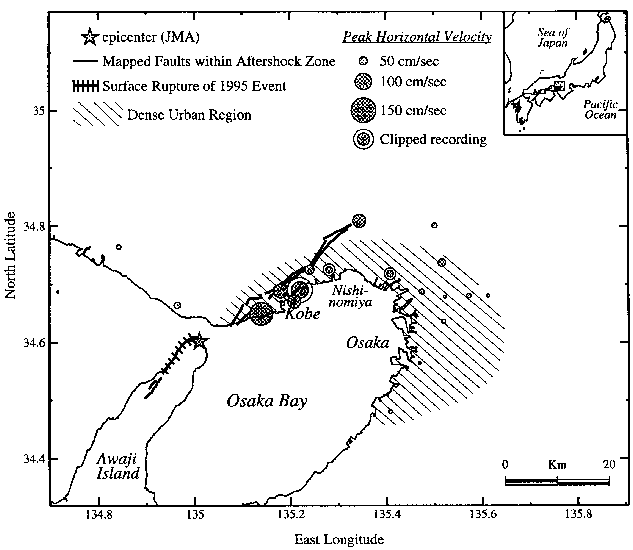
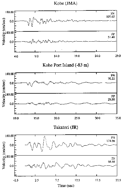
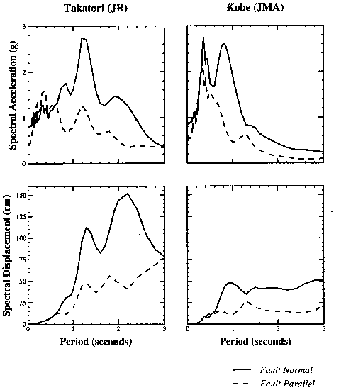
The rupture of this strike-slip earthquake directly into downtown Kobe (Figures 2.1 and 2.4) caused near-fault rupture directivity effects which appear to have contributed to the high level of damage. As stated previously, the near-fault ground velocity time histories have large, brief pulses of ground motion (Figure 2.12) which are indicative of rupture directivity effects and are potentially damaging to multi-story buildings and other long-period structures such as bridges. The recorded peak velocities were as large as 175 cm/sec at Takatori in western Kobe, and the largest values occurred in the densely populated urban region, as shown in Figure 2.13. The near-fault horizontal peak velocities were 55 cm/sec on rock at Kobe University and went off scale at soil sites at levels of 40 cm/sec and 100 cm/sec in central Kobe. These values are similar to those recorded close to comparable earthquakes in California. Currently, buildings over 60 meters in height in Japan are designed to withstand peak velocities of 50 cm/sec in Tokyo and 40cm/sec in the Osaka-Kobe area without collapse. The horizontal motions in the fault-normal direction are about twice as large as those in the fault-parallel direction, as seen in the velocity-time histories shown in Figure 2.14 and the response spectra shown in Figure 2.15. This feature, which is caused by rupture directivity effects, has been widely observed in near fault strong motion data in California (e.g. Somerville and Graves, 1993) and quantified as a modification to empirical attenuation relationships recently proposed by Somerville and Graves (1995).
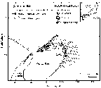 Figure 2.13: Location of the mainshock epicenter, mapped active faults within the aftershock zone (including surface rupture of the Nojima fault on Awaji Island), the dense urban region, and peak velocities recorded from the 1995 Kobe earthquake.
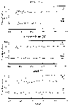 Figure 2.14: Recorded velocities at Kobe JMA, Port Island at a depth of 83 m, and Takatori rotated into fault-normal and fault-parallel components.
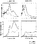 Figure 2.15: Response spectral acceleration (top) and displacement (bottom) of the fault-normal and fault-parallel components of the Kobe earthquake recorded at Kobe JMA and Takatori.
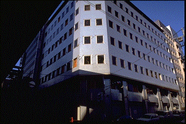
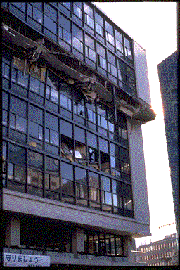
Due to near-field rupture directivity effects, the structural damage in central Kobe was noticeably influenced by the orientation of the structural system with respect to the strike of the fault. Structural damage was more severe in the fault-normal direction than in the fault-parallel direction. For example, the seven story office building shown in Figure 2.16 has shear cracking of the building cladding, with extensive window damage, in the fault-normal direction and little damage in the fault-parallel direction. Buildings characteristically displayed interstory damage, such as that shown in Figure 2.17, in the fault-normal direction. Moreover, the collapse of the Hanshin elevated expressway appeared to result from strong displacement pulses in the fault-normal direction, which is perpendicular to the orientation of the highway.
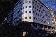 Figure 2.16: Office building in Kobe with significant cladding damage in the fault-normal direction (left side) and little damage in the fault-parallel direction. Photograph courtesy of C. Thewalt, UC Berkeley.
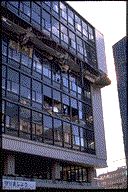 Figure 2.17: Building in central Kobe with mid-height story collapse in the fault-normal direction.
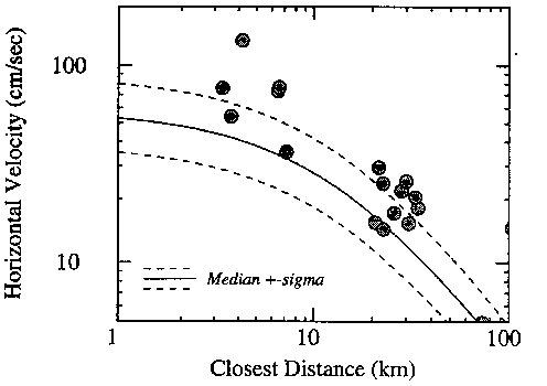
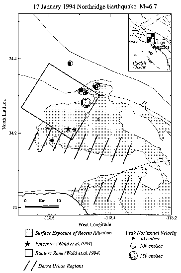
The recorded peak horizontal accelerations from the Kobe earthquake are comparable to those predicted for a strike-slip earthquake using the Abrahamson and Silva (1995) empirical attenuation relation for soil based mainly on California data, as shown in Figure 2.18. The recorded peak horizontal velocities are slightly higher (about one standard deviation higher) than those predicted for a similar event using the Campbell (1990) empirical attenuation relation for soil based mainly on California data, as shown in Figure 2.19. The much larger level of damage that occurred in the Kobe earthquake compared with that of recent earthquakes in California may be attributable in part to the fact that the dense urban region of Kobe was subject to strong rupture directivity effects. As shown in Figure 2.13, the largest peak velocities recorded from the Kobe earthquake were in the dense urban region. Peak velocities as large and larger than these values were recorded during the 1994 Northridge earthquake. However, as shown in Figure 2.20, the dense urban region of the southern San Fernando Valley and the northwest Los Angeles basin were not subject to rupture directivity effects. The effects were experienced in the northern San Fernando Valley and Santa Susana Mountains, which are located away from the dense urban region. Other factors, such as quality of construction and evolution of the respective design codes, also contributed to the different levels of damage observed during the Northridge and Kobe earthquakes.
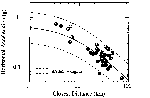 Figure 2.18: Attenuation of recorded peak horizontal acceleration at soil sites from the Kobe earthquake, compared with empirical relations for strike-slip earthquakes recorded on soil based mainly on California data (Abrahamson and Silva, 1995).
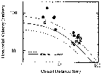 Figure 2.19: Attenuation of recorded peak velocity at soil sites from the Kobe earthquake, compared with empirical relations for strike-slip earthquakes recorded on soil based mainly on California data (Campbell, 1990).
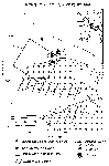 Figure 2.20: Location of the mainshock epicenter, surface projection of the fault rupture model of Wald and Heaton (1994), dense urban regions, and peak ground velocities recorded from the 1994 Northridge earthquake.
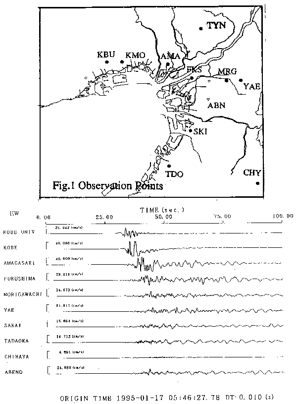 Figure 2.12: Velocity waveforms (horizontal east-west component) recorded by the Kinki Strong Motion Observation Network. Source: GeoResearch Institute, 1995.