2.7 Site Response
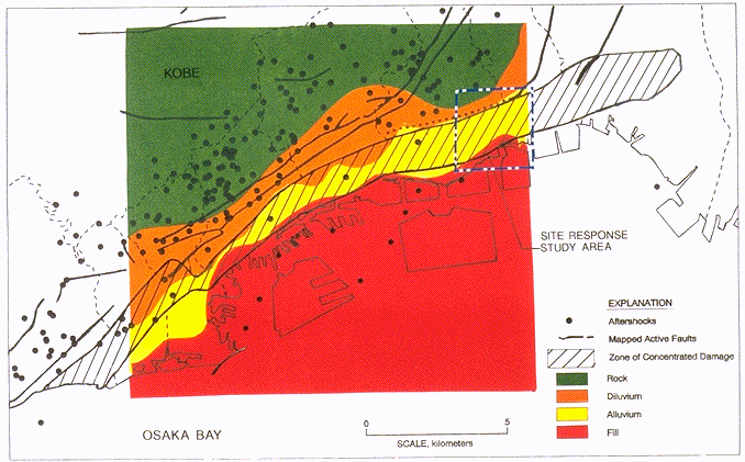
Severe damage to buildings due to the Kobe earthquake was observed along a strip about 30 km long and 1 km wide. Figure 2.21 shows the severely damaged area, active faults, and aftershock distribution (Kohketsu, 1995). The hachured zone indicates the area where the rate of collapsed wood-frame buildings is more than 30%; this rate exceeded 70% in the central part of this area. To investigate whether these large variations in site response in the Kobe area were attributable to site effects, investigators from Ohsaki Research Institute recorded aftershocks at several sites on alluvium in the heavily damaged area as well as at rock sites on the foot of Rokko mountain in Kobe (Kawase et al, 1995). The locations of their stations are shown in Figure 2.22, and their study area is shown as an inset in Figure 2.21. They found that, for six aftershocks, horizontal peak accelerations recorded at three sites located on a thin layer of alluvium (about 10 to 15 meters thick) were about 3 to 5 times larger than those at a reference site on rock, as shown in Figure 2.22.
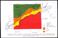 Figure 2.21: Location of zone of intense destruction in the Kobe area, and its relationship to the location of active faults, the aftershock distribution, and geological site conditions. Modified from Kohketsu (1995).
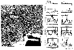 Figure 2.22: Left: Locations of aftershock recording sites used in the site response study conducted by Kawase et al. (1995). The location of the study area is shown in Figure 2.21. Right: Fourier spectral ratios, averaged over six aftershocks and referenced to rock site KMC, for diluvial site KOB, alluvial sites FKI and ASY, and fill site FKE. Source: Kawase et al. (1995).
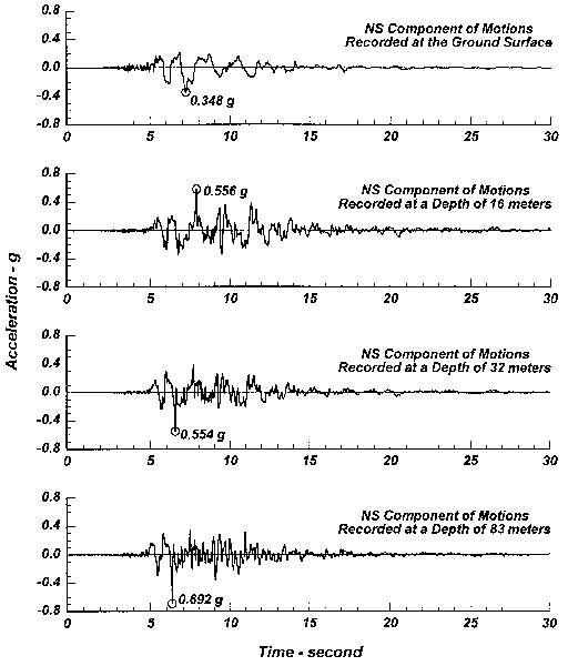
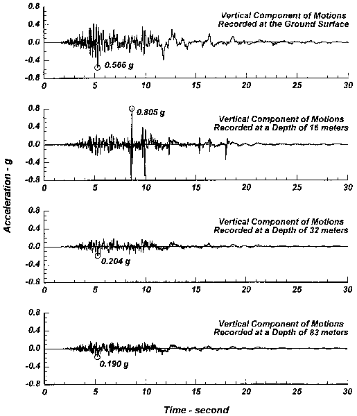
A downhole array on the northwest corner of Port Island (see insert in Fig. 2.23), which is located just south of downtown Kobe, provides valuable site response data. Strong motion instruments were located at the ground level and at depths of 16 m, 32 m, and 83 m. The generalized soil profile, with shear wave velocities (Iwasaki, 1995), is shown is Figure 2.23. The thickness of Quaternary deposits at this site is on the order of 1000 m. Acceleration-time histories for each component are shown in Figures 2.24-2.26. The horizontal acceleration-time histories shown in Figures 2.24 and 2.25 clearly show the initiation of liquefaction in the loosely dumped granular fill located between a depth of 12 m and the ground level. Moreover, the instrument records show the characteristics of the near-field response (i.e. brief, intense pulses) at this deep soil site. The peak ground accelerations tended to be sustained or to increase slightly as the motions propagated to the ground surface, except through the liquefied fill deposit.
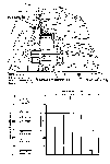 Figure 2.23: Generalized soil profile with shear wave velocity data at the downhole array site on the northwest corner of Port Island. Source: Iwasaki (1995).
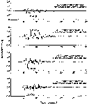 Figure 2.24: Horizontal acceleration-time histories recorded at Port Island downhole array; NS direction. Source: GeoResearch Institute, 1995.
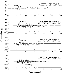 Figure 2.25: Horizontal acceleration-time histories recorded at Port Island downhole array; EW direction. Source: GeoResearch Institute, 1995.
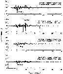 Figure 2.26: Vertical acceleration-time histories recorded at Port Island downhole array. Source: GeoReserch Institute, 1995.
The Kansai International Airport is built on reclaimed ground similar to Port Island, but it is located about 30 km from the zone of energy release, so the motions are significantly lower. Free-field instruments located at the northern and southern ends of the runway recorded ground level maximum horizontal accelerations (MHA) of 0.15 g and 0.09 g, respectively. The terminal building has strong motion instruments located at its basement, fourth floor and roof levels. The MHA recorded at the basement level was relatively low at only 0.04 g, whereas, at the fourth floor level, the recorded MHA increased to 0.10 g. One of the piers of the bridge that connects Kansai Airport Island to the mainland has instruments located at its bottom and top, and these instruments recorded MHAs of 0.13 g and 0.27 g, respectively. These data from the strong motion instrumentation array at the Kansai International Airport present a valuable opportunity for further investigation of site response and soil-structure interaction issues.
 Figure 2.22: Left: Locations of aftershock recording sites used in the site response study conducted by Kawase et al. (1995). The location of the study area is shown in Figure 2.21. Right: Fourier spectral ratios, averaged over six aftershocks and referenced to rock site KMC, for diluvial site KOB, alluvial sites FKI and ASY, and fill site FKE. Source: Kawase et al. (1995).