Chapter Three: Liquefaction and Related Effects
3.1 Introduction
Extensive liquefaction of filled land occurred throughout the region affected by strong ground motion. The general setting of the Kobe and Osaka metropolitan regions, on the margins of a major bay flanked by mountains, resulted in a gradual but extensive reclamation of land along the bay margins. Infilling of the bay has occurred along most of the waterfront over a long period of time, and in many places these fills are liquefiable or have been placed over liquefiable beach sand deposits. In addition, the rapid expansion of port facilities, mainly after 1963, has led to extensive construction of man-made islands. These islands were constructed using the most readily available local material: decomposed granite, which is a relatively coarse granular material that is quite susceptible to liquefaction unless well compacted.
Severe liquefaction occurred on Rokko and Port Islands (Figure 3.1), and in most of the port areas along the Kobe mainland. Some of the most damaging effects were lateral spreads around the margins of Rokko and Port Islands and mainland port areas, and ground settlement in the interior of Rokko and Port Islands. However, liquefaction effects were widespread as far as 3 km inland from the waterfront, and for several kilometers laterally along the bay. These effects caused minor disruption to residential and industrial areas of Kobe, Nishinomiya, and Ashiya within the narrow urban corridor that lies between the bay to the south and the mountains to the north. Evidence of liquefaction in areas away from the waterfront consisted of buckled and fractured curbs, walkways, and other pavements (Figure 3.2); small ground fissures; sporadic sand boils; and small amounts of ground settlement. Interestingly, liquefaction seems to have had relatively little influence on the structural damage observed in many of these areas; in fact, buildings of various types seem to have survived remarkably well in view of the liquefaction-induced ground deformations (Figure 3.3). Damage to underground utilities, however, was extensive throughout the liquefied area.
 Figure 3.1: General loacation reference map of the Kobe waterfront.
 Figure 3.2: Evidence of liquefaction damage in a residential area of Nishinomiya; buckled pavement, cracked curbs, differential settlement.
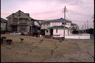 Figure 3.3: Relatively undamaged houses in a residential area in Ashiya. Note the evidence of lateral spreading caused by the liquefication of the fill.
 Figure 3.1: General loacation reference map of the Kobe waterfront.
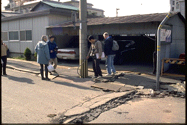 Figure 3.2: Evidence of liquefaction damage in a residential area of Nishinomiya; buckled pavement, cracked curbs, differential settlement.
 Figure 3.3: Relatively undamaged houses in a residential area in Ashiya. Note the evidence of lateral spreading caused by the liquefication of the fill.