Chapter Five: Peformance of Dams and Levees
5.1 Performance of Dams
Aerial reconnaissance and available maps show that there are numerous small dams and reservoirs both on Awaji Island and in the Kobe Area. These dams appear to be typically 10- to 20-meter-high earth embankments and serve to store water for presumably agricultural use on Awaji Island and urban use in the Kobe area. The dams in the Kobe area also appear to provide recreation and flood protection benefits. In addition to the small embankment dams, there are at least two moderately-sized concrete gravity dams: Karasuhara and Nunobiki Dams. Both dams were identified by aerial reconnaissance and appear to store the largest reservoirs in the immediate Kobe area (see Figure 3.1 for locations).
The reservoirs for most of the dams surveyed two weeks after the earthquake seemed substantially below maximum reservoir elevation. In many cases, the reservoir surface elevations appeared to be less than half their maximum heights. In general, preliminary reports indicate that most dams performed well with little or no damage noted. The principal exception to this was the failure of the relatively small Upper and Middle Niteko Dams, together with significant damage sustained at the Lower Niteko Dam.
5.1.1 Upper, Middle, and Lower Niteko Dams
The Upper, Middle, and Lower Niteko Dams are located approximately 4 kilometers north of Nishinomiya in an urban portion of the eastern Kobe region (Figure 3.1). The earthquake was estimated to have induced peak ground accelerations of approximately 0.3 to 0.5g in this area. All three dams are reported to have been constructed over 100 years ago with minor additions and modifications made to them in more recent times. Their current use is to retain small reservoirs or ponds, presumably for water supply and recreation uses. At the time of the earthquake, all three reservoirs were reported to be relatively low, impinging only on the lower third of each dam. All three dams had large trees and/or brush growing in their downstream slopes. Figure 5.1 presents a schematic diagram illustrating the general arrangement of the dams together with a general picture of the performance of the structures. Figure 5.2 shows an aerial photograph of the three dams and reservoirs.
 Figure 5.1: Schematic plan of Niteko Dam Complex.
 Figure 5.2: Aerial photograph of Niteko Dam Complex.
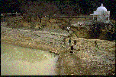
The Lower Niteko Dam is the largest of the three dams with a maximum height of approximately 12 meters and a crest length of about 120 meters. It has an estimated crest width of about 8 meters and was estimated to have 2:1 to 2.5:1 (horizontal:vertical) upstream and downstream slopes. It also has a 1.5-meter-high retaining wall at its downstream toe. Of the three dams, the Lower Niteko Dam performed the best. This relatively good performance may be due to the fact that some reports indicate that this reservoir was kept nearly empty to alleviate seepage problems being experienced at residences downstream. Nevertheless, the dam sustained major cracking and slumping in the middle of the embankment, losing as much as 2 meters of height (Figure 5.3). Although the slumping appeared to be more towards the upstream direction, there were also significant cracks (10 centimeter widths) observed on the downstream slope near the left abutment. A portion of the downstream retaining wall was also cracked.
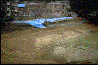 Figure 5.3: Upstream slope of Lower Niteko Dam.
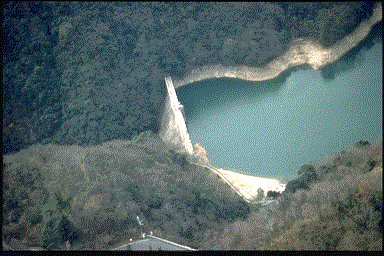
The Middle Niteko Dam had a maximum height of approximately 10 meters and a crest length of about 80 meters prior to the earthquake. It had a crest width of about 2 1/2 meters and was estimated to have had 2:1 to 2.5:1 upstream and downstream slopes. As a result of the earthquake, the dam experienced a flow failure reminiscent of the 1925 Sheffield Dam failure in California (Seed et al., 1969). The upper two-thirds of the dam in the central portion appeared to have flowed as much as 70 meters downstream of the dam's centerline (Figure 5.4). At the time of the earthquake, the reservoir was reported to be only slightly higher than the level shown in the photographs. In addition, a small flow of reservoir water was still passing through the breach at the time of the field reconnaissance, 17 days after the earthquake.
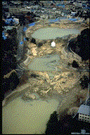 Figure 5.4: Aerial photograph of flow failures at Upper and Middle Niteko Dams.
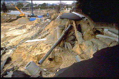
The flow movement of the Middle dam appeared to be almost entirely in the downstream direction, although examination of the remaining portions of upstream slope near the abutments indicated minor slumping towards the reservoir. The small outlet structure at the upstream toe near the center of the dam appeared to be nearly vertical with a possible slight upstream tilt, although the catwalk to the structure had collapsed (Figure 5.5). Exposures of the upper portion of the dam near the abutments indicated a layered fill composed of sandy silt and silty sand with gravel. However, the slide debris seemed composed mostly of sandy silt. All of the fill soils were believed to originate from decomposed granite.
 Figure 5.5: Crest alignment of failed Middle Niteko Dam.
The Upper Niteko Dam also had a maximum height of approximately 10 meters and a crest length of about 80 meters prior to the earthquake. Its crest width had also been 2 1/2 meters and it was also estimated to have had 2:1 to 2.5:1 upstream and downstream slopes. The Upper dam sustained a flow failure very similar to the failure observed at the Middle Dam. The upper two-thirds of the central Upper dam appeared to have also flowed as much as 60 to 70 meters downstream of the dam's centerline (Figure 5.4). Portions of the flow passed around a downstream outlet tower. This tower appeared to have remained stable, together with a possible slight downstream tilt, with little exterior damage observable. The exception to this was the damage sustained as a result of its catwalk being jammed through its doorway into the tower interior by the flowing ground (Figure 5.6). As at the Middle dam, the flow failure observed at the Upper dam seemed to be almost entirely in the downstream direction. However, there was somewhat more slumping of the remaining upstream slope than that observed at the Middle dam (Figure 5.7).
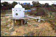 Figure 5.6: Downstream outlet tower at Upper Niteko Dam.
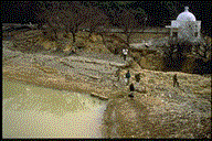 Figure 5.7: Upstream slope of Upper Niteko Dam.
The perimeter roadway fills along the margins of the Upper and Middle Niteko reservoirs also sustained flow failures following the earthquake (Figure 5.1). These perimeter fills were reported to have initially failed either during or shortly after the main shock. Some were then quickly rebuilt and resurfaced with new asphalt concrete only to fail again following the occurrence of a strong aftershock a few days later (Figure 5.8).
 Figure 5.8: Failed perimeter roadway fill along Upper Niteko Reservoir.
The flow failures of the Upper and Middle Niteko Dams, along with the extensive failures of the perimeter fills, strongly suggest that liquefaction was responsible, despite the fact that sediment boils were not observed within the reservoirs during the reconnaissance. However, in the residential neighborhood to the west there was ample evidence of liquefaction in the form of sand ejecta and sand boils. Shortly after the earthquake, a borehole was drilled into each dam embankment to obtain SPT data (see drill rig in Figure 5.3). Reports indicate that the blowcounts within the dam embankments generally ranged between 2 and 10 blows per 30 cm, with mean values around 5 to 6 blows per 30 cm. Blowcounts in the foundation soils beneath the embankments were generally greater than 25 blows per 30 cm. These results suggest that the saturated lower portions of the embankments would have been more likely to liquefy than the foundation soils. Good performance of the foundation soils is also indicated by the good performance of the outlet towers at the Middle and Upper Niteko Dams. The perimeter road fills may also have failed due to liquefaction of the saturated fill or due to liquefaction of less competent foundation material. Overall, it was not possible to discern the relative contributions of possible reservoir releases or aftershocks on the development of the flow slides.
5.1.2 Kitayama Dam
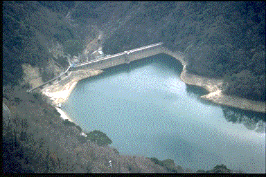
Kitayama Reservoir is one of the larger reservoirs in the eastern Kobe region and is located approximately 6 kilometers north of Nishinomiya (see Figure 3.1). The earthquake was estimated to have induced peak ground accelerations between 0.2 and 0.4g in this area. The reservoir is situated at the top of a hill and is retained by five embankment dams (Figure 5.9). The largest embankment is located on the south side and is estimated to have a maximum height of approximately 25 meters (Figure 5.10). This embankment is reported to have a homogeneous cross section with an internal chimney/blanket drain and was completed in 1962. The field reconnaissance consisted of aerial reconnaissance and limited ground inspections of the embankment crests. No damage was observed during the ground inspections of the crests and the embankments appeared to have generally performed well. However, the aerial reconnaissance discovered what appeared to be significant longitudinal cracking along approximately 100 m of the upstream slope of the main embankment just above the water line (Figures 5.10 and 5.11). There also appeared to be a scarp approximately one meter high associated with this crack. The cracking was indicative of possible upstream slumping of the slope, but no other distress was observed on the slopes above the cracks. It is not known if the apparent cracking is significant or if it involves only surface slope protection materials. Additional investigation is needed to clarify the performance of the dam.
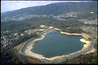 Figure 5.9: Aerial photograph of Kitayama Reservoir.
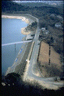 Figure 5.10: Aerial photograph of Kitayama South Dam.
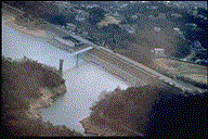 Figure 5.11: Aerial photograph of cracking on upstream slope of Kitayama South Dam.
5.1.3 Karasuhara Dam
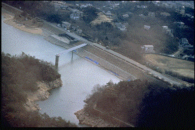
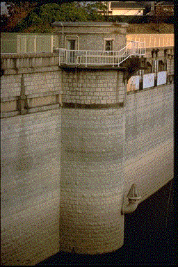
Karasuhara Reservoir appears to be the largest reservoir in the immediate Kobe area and is located approximately 4 kilometers northwest of the Port Island Bridge (Figure 3.1). The dam appears to be a cemented masonry gravity dam constructed to have a horizontal curve. The dam was estimated to have a maximum height of approximately 35 to 45 meters and incorporates an outlet tower on the upstream center of the dam (Figures 5.12 and 5.13). A monument on the crest of the dam indicates that the dam was originally completed in 1904 and had a 3-meter raise in 1914.
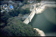 Figure 5.12: Aerial photograph of Karasuhara Dam.
 Figure 5.13: Outlet tower on Karasuhara Dam.
The earthquake was estimated to have induced peak ground accelerations between 0.4 and 0.6g in this area. Karasuhara Dam was surveyed by both aerial and limited ground inspection of the dam crest. The reservoir surface appeared to be approximately 14 meters below the crest of the dam during the field reconnaissance. Overall, the dam appeared to have performed well. No offsets were observed on the crest, and no seepage could be seen on the downstream face of the dam (Figure 5.14). Only one crack was observed in the dam crest. The crack was oriented approximately perpendicular to the dam axis, had a width of about 1-2 millimeters, and appeared to be very old (Figure 5.15).
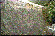 Figure 5.14: Downstream face of Karasuhara Dam.
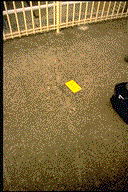 Figure 5.15: Old crack observed on crest of Karasuhara Dam.
5.1.4 Nunobiki Dam
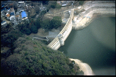
Nunobiki Reservoir appears to be the second-largest reservoir in the immediate Kobe area and is located approximately 3 kilometers north of the Port Island Bridge (Figure 3.1). The dam appears to be a concrete gravity dam constructed with a straight axis (Figure 5.16). As with Karasuhara Dam, Nunobiki Dam incorporates an outlet tower within the upstream center of the dam (Figure 5.17). Nunobiki Dam was estimated to have a maximum height of approximately 35 to 45 meters.
 Figure 5.16: Aerial photograph of downstream face of Nunobiki Dam.
 Figure 5.17: Aerial photograph of upstream face of Nunobiki Dam.
The earthquake was estimated to have induced peak ground accelerations between 0.4 and 0.6g in this area. The reservoir surface appeared to be approximately 10 to 15 meters below the crest of the dam during the field reconnaissance. Nunobiki Dam was surveyed only by aerial reconnaissance and no damage was observed.
5.1.5 Summary
The results of the field reconnaissance, together with reports supplied by Japanese colleagues, indicate that modern dams in the Kobe area generally performed well. This behavior matches the good behavior of modern dams in North America following the recent Loma Prieta and Northridge Earthquakes. The only dams known to have sustained major damage were the old, presumably non-engineered Niteko Dams. This latter behavior also matches the experience in North America (e.g. Sheffield Dam, Upper and Lower San Fernando Dams).
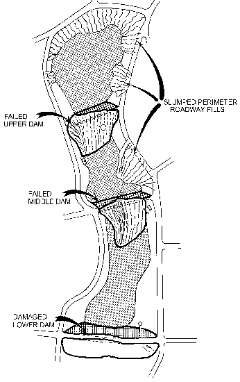 Figure 5.1: Schematic plan of Niteko Dam Complex.
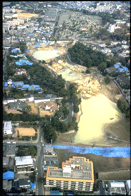 Figure 5.2: Aerial photograph of Niteko Dam Complex.