[return to Ground Motions section]
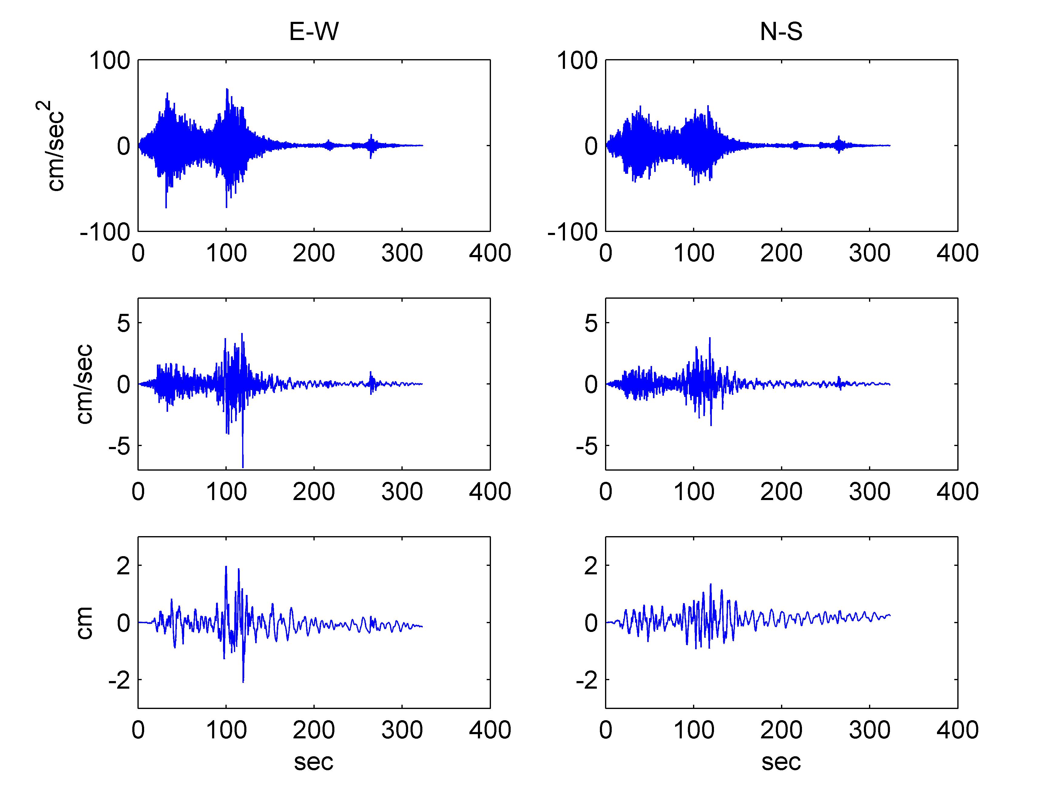
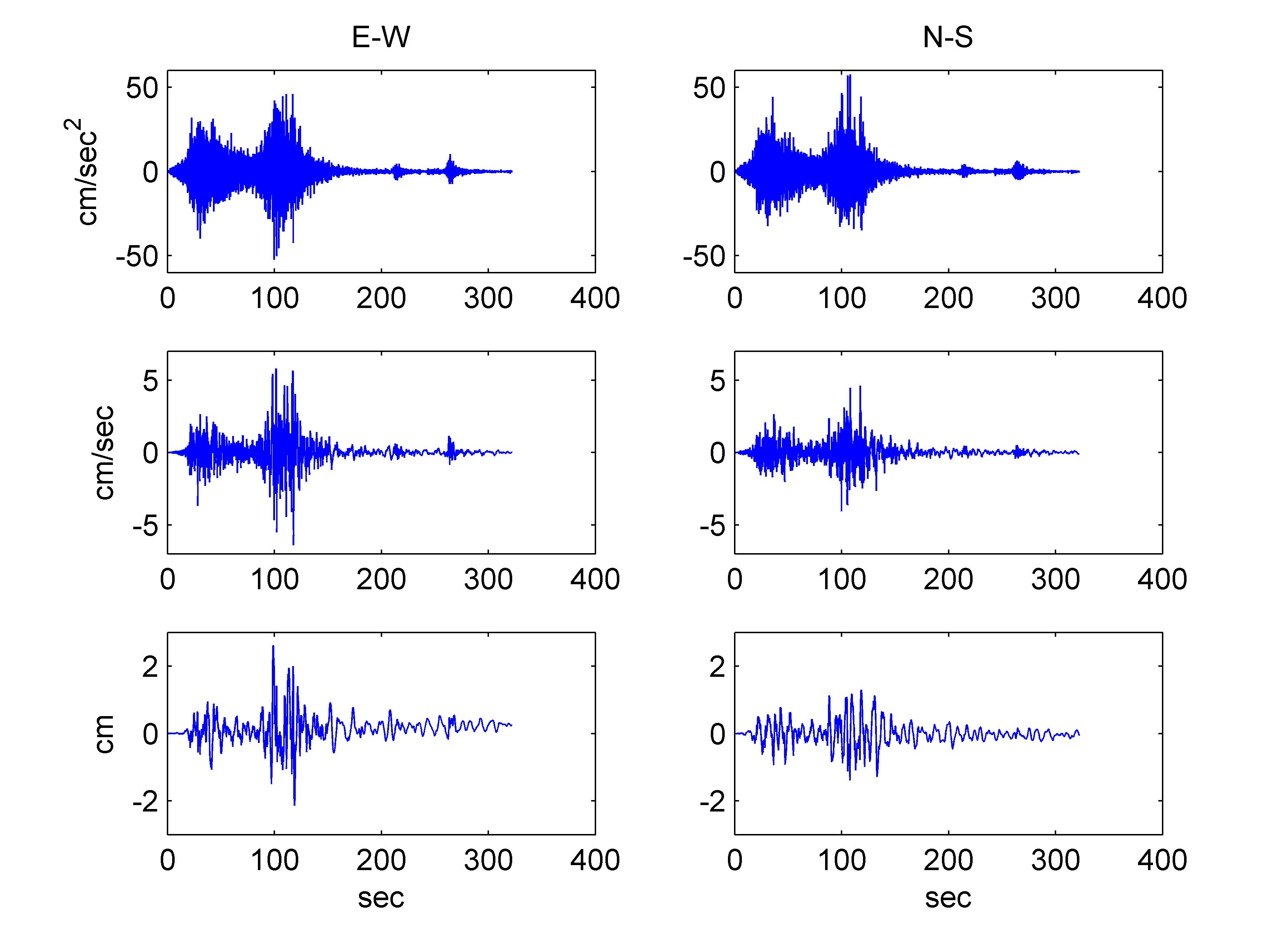
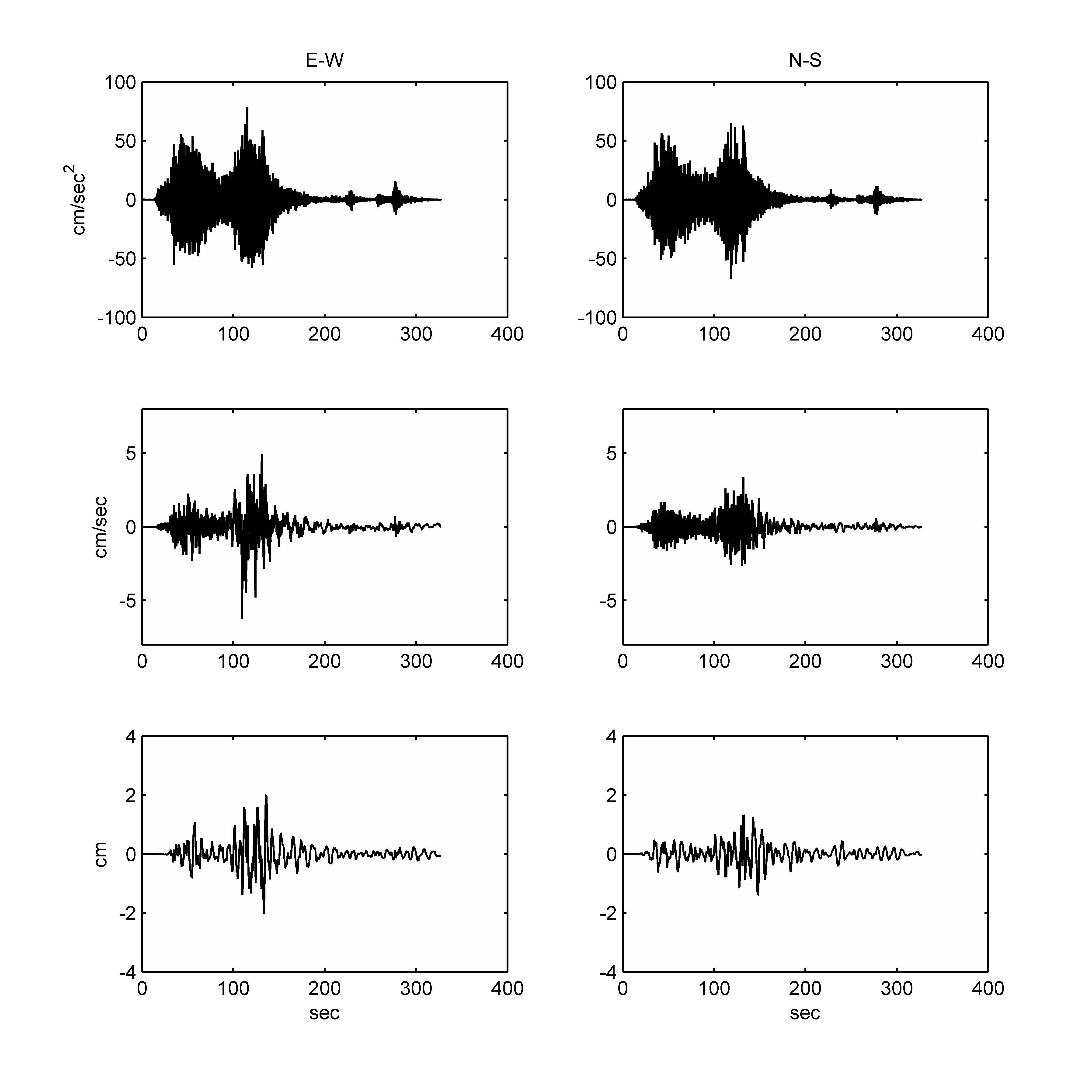
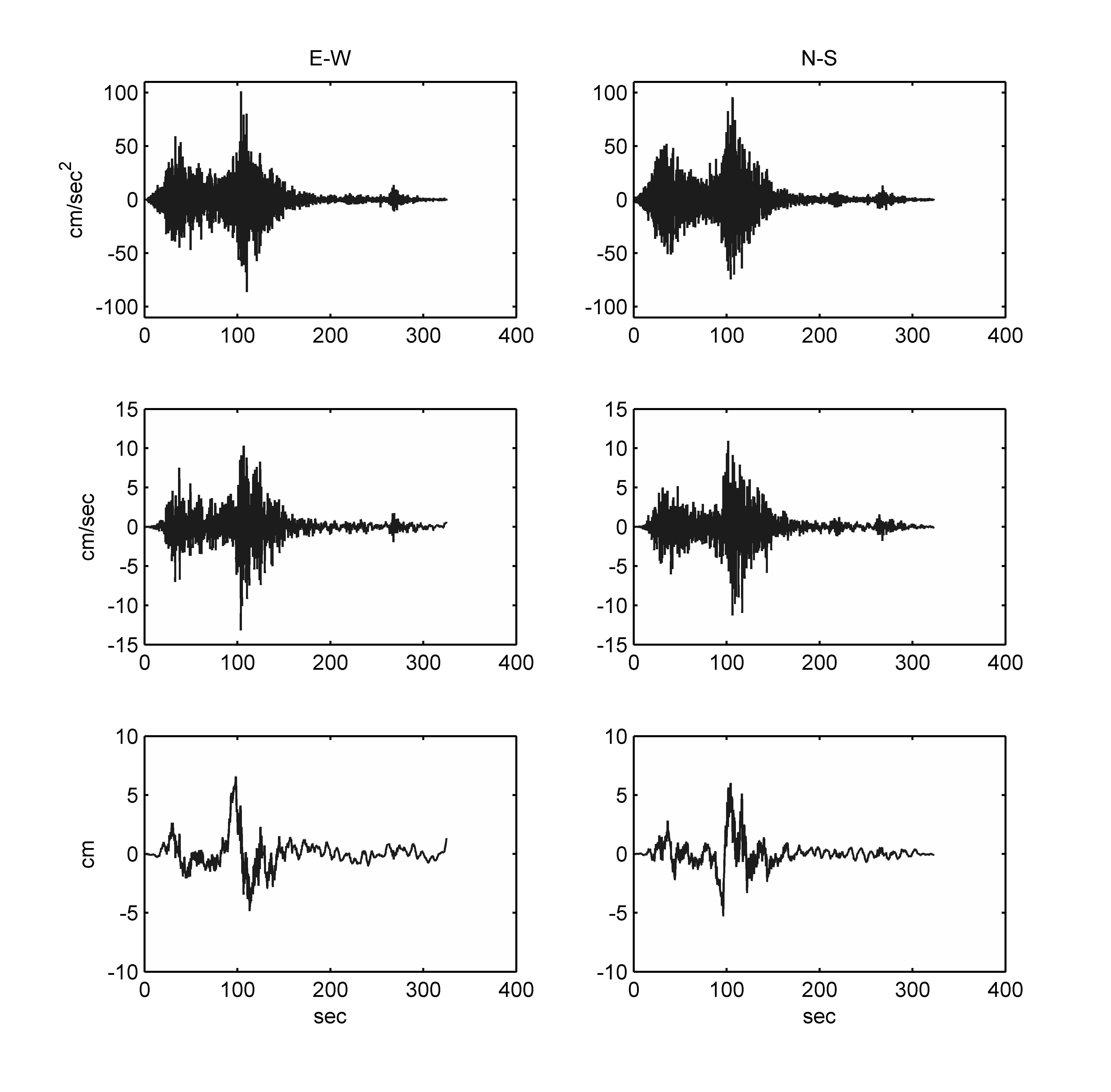
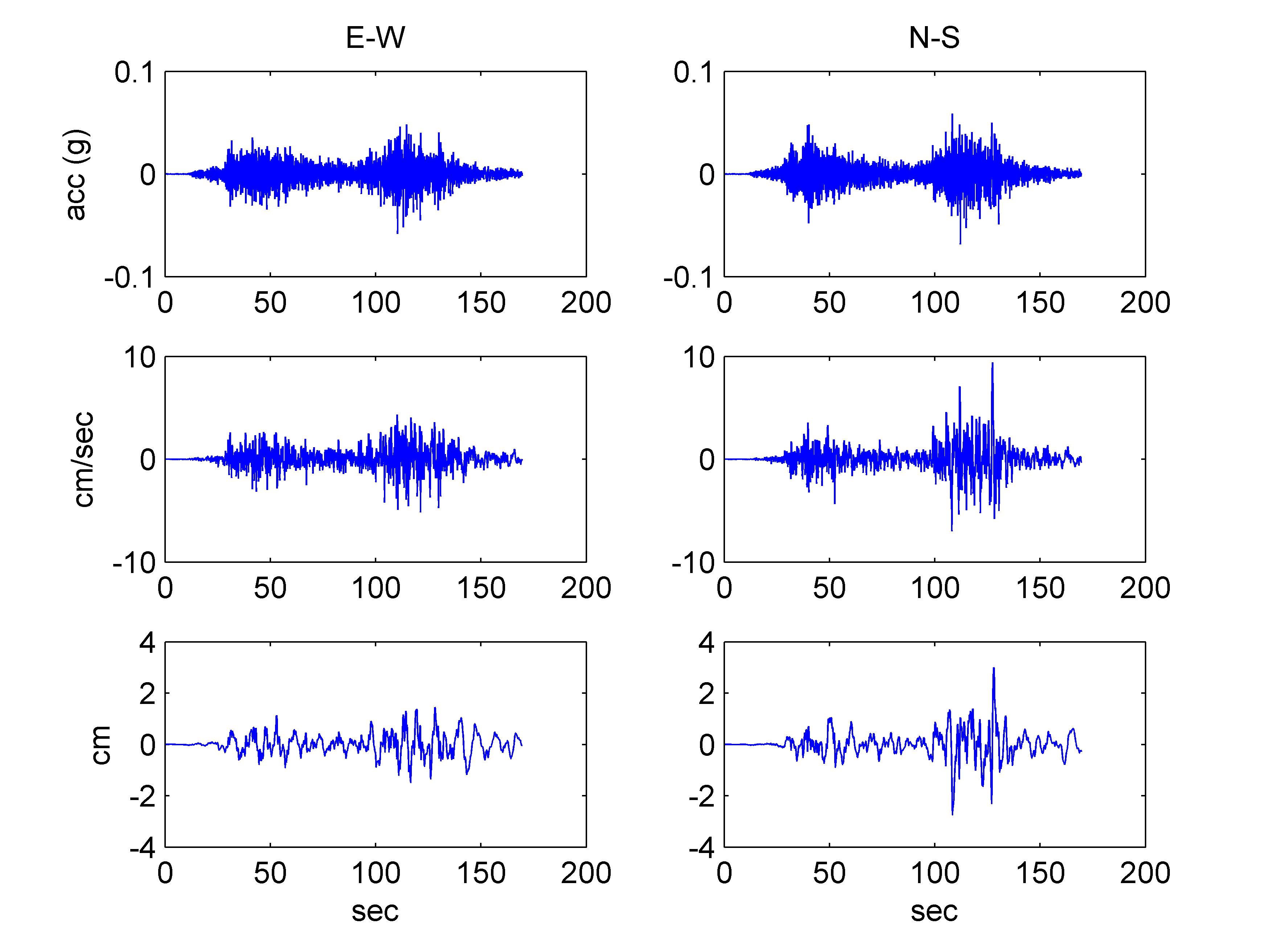
Table 2.1 Ground motion stations that recorded the 2007 Pisco Earthquake. The PGA values reported in this table were obtained from Tavera et al. (2007). Click on each station name to see time histories (for those that are available).
|
Organization (a) |
Code |
Location |
City |
PGA UD (cm/s2) |
PGA NS (cm/s2) |
PGA EW (cm/s2) |
PGA (g) |
Closest Distance (km) (b) |
Site Type (c) |
|
IGP |
Parcona |
Ica |
301.0 |
455.0 |
488.0 |
0.498 |
39.4 |
Soil |
|
|
IGP |
Mayorazgo |
Lima |
31.2 |
59.7 |
55.0 |
0.061 |
103.0 |
Soil |
|
|
IGP |
Ancón |
Ancón |
27.8 |
54.7 |
58.4 |
0.060 |
137.5 |
Soil |
|
|
IGP |
LMO |
La Molina |
Lima |
14.2 |
21.2 |
25.3 |
0.026 |
100.3 |
Rock |
|
IGP |
NNA |
Ñaña |
Lima |
21.6 |
18.7 |
22.1 |
0.023 |
105.4 |
Rock |
| CISMID | ICA2 | Universidad | Ica | 192.2 | 334.1 | 272.3 | 0.341 | 36.7 | Soil |
|
CISMID |
Rimac |
Lima |
32.9 |
45.1 |
73.9 |
0.075 |
111.1 |
Firm Ground |
|
|
CISMID |
San Isidro |
Lima |
33.1 |
58.8 |
54.1 |
0.060 |
103.7 |
Firm Ground |
|
|
CISMID |
La Molina |
Lima |
56.8 |
69.1 |
78.7 |
0.080 |
96.8 |
Soil |
|
|
CISMID |
Callao |
Callao |
31.6 |
101.0 |
95.8 |
0.103 |
111.1 |
Soil |
|
|
PUCP |
U. Catolica |
Lima |
39.7 |
59.6 |
67.0 |
0.068 |
106.7 |
Firm Ground |
|
|
CERESIS |
Rinconada |
Lima |
57.7 |
115.0 |
111.0 |
0.117 |
99.3 |
Soil |
|
|
CERESIS |
A. Nac. Rectores |
Lima |
73.5 |
65.2 |
85.3 |
0.087 |
100.1 |
Firm Ground |
|
|
CERESIS |
Ceresis |
Lima |
37.3 |
58.0 |
58.7 |
0.060 |
102.4 |
Firm Ground |
|
|
Sedapal |
E1(d) |
Atarjea |
Lima |
30.4(d) |
50.0(d) |
54.9(d) |
0.056 |
106.2 |
Soil |
|
Sedapal |
E2 |
Atarjea |
Lima |
11.8 |
12.7 |
20.6 |
0.021 |
105.9 |
Rock |
(a) IGP: Geophysical Institute of Peru (http://www.igp.gob.pe/).
CISMID: Centro Peruano Japonés de Investigaciones Sísmicas y Mitigación de Desastres (http://www.cismid-uni.org/).
PUCP: Catholic University of Peru (http://www.pucp.edu.pe/).
CERESIS: Centro Regional de Sismología para America del Sur (http://www.ceresis.org/new/es/index.html).
Sedapal: (http://www.sedapal.com.pe/).
(b) Measured from the fault plane of Ji and Zeng (2007).
(c) Inferred from local zonation maps (Aguilar and Alva 2007) and from Tavera et al. (2007), and can only be considered an estimation. Firm ground stations are those located in a deposit locally known as "Lima Conglomerate", a dense, slightly cemented gravel deposit.
(d) Station E1 is located on an embankment crest.