
Photographs taken by members
of the geotechnical reconnaissance team
|
Landslides triggered by the Colima earthquake were observed during both aerial and ground reconnaissance. Aerial reconnaissance was carried out in a 4-seat, fixed-wing aircraft on the morning of Jan. 29 and covered most of the state of Colima and immediately adjacent parts of the state of Jalisco to the east of the volcanoes, Nevado de Colima and Volcan de Colima (Volcan de Fuego). Ground reconnaissance involved automobile traverses in the vicinity of Manzanillo; from Manzinillo south through Tecomán to Cerro de Ortega; from Manzanillo to Colima via Mexico Highways 200 and 110; from Colima through Minatitlán to Manzinillo via secondary roads; and several traverses along secondary roads north of Colima around the area of the volcanoes. Limited traverses by foot were also carried out at selected localities. In all, the earthquake triggered landslides with numbers estimated in the thousands. As classified according to the system of Keefer (1984), the vast majority were disrupted landslides, specifically rock falls, rock slides, soil falls, and disrupted soil slides. Several liquefaction-induced soil lateral spreads were also observed (Figure 1), as was a single embankment failure that is classified as a coherent slide. Two areas of particularly high landslide concentrations were noted. The first of these was along the steep walls of the Rio Armería and its tributary, the Rio Remate, north of Colima in the vicinity of the town of Zacualpan. Along each river, a stretch of 6 to 8 km was subjected to such intense landsliding that material was removed from stretches of slope hundreds of meters to more than a kilometer long in each of several localities (Figure 2). Most or all of these areas were on the outside of meander bends. The cliffs where the landslide occurred were typically 150 to 200 high and had slope inclinations estimated as ranging from about 70 º to vertical. They were composed of very well graded volcanic debris-avalanche material reworked by fluvial action and interbedded with fluvial deposits. These materials had little or no matrix cementation. When this area was visited on the ground on Jan. 28 and again on Jan. 31, the cliffs were so unstable that together they were still producing several falls each minute (Figure 3). On Jan. 31, in fact, 20 falls occurred from a single 1-km-long section of cliff in a period of 15 minutes, suggesting that approximately 2000 falls were occurring there each day. These were typically small, ranging from a few cubic meters to perhaps 50 cubic meters of material each. The continuing instability of these cliffs, exacerbated by the ongoing removal of material by falls, indicates a possible continuing hazard to villages, dwellings, and other infrastructure in this area located close to the cliffs. The other area of high landslide concentration was along a 6-km stretch of the Barranca de Atenquique, a deep, steep-sided canyon cut into the eastern flank of Nevado de Colima. There rock falls, soil falls, rock slides, and debris slides occurred in volcanic materials exposed on canyon walls, typically consisting of an upper fine-grained pyroclastic deposit, a middle unit consisting of well-indurated lava, and a lower unit consisting of a pyroclastic block-and-ash flow deposit (Figures. 4 and 5). Volumes of the individual landslides typically ranged from a few to a few hundreds of cubic meters each, and the highest landslide concentrations ranged up to about 40 landslides per linear kilometer of canyon wall. Slopes were near vertical and ranged up to about 500 m high. The landslides in this area damaged some irrigation systems. Three smaller areas with moderate landslide concentrations were also observed from the air. Two of these, on the south flank of Volcan de Fuego and along several smaller canyons south of the Barranca de Atenquique, evidently involved similar materials to those along the Barranca de Atenquique. The third area, along the lower valley of the Rio Armería near the coast, produced a moderate number of landslides along highway and railroad cuts as well as along the bedrock valley walls. Outside of the areas discussed above, nearly all of the disrupted landslides that occurred were along artificial cuts. Fewer than 20 landslides from natural, unaltered slopes were observed outside those areas during either aerial or ground-based reconnaissance. The largest cut-slopes failures were along the Colima to Minatitlán road, between the Rio Armería and the village of Platanarillos (Figure 6). Cut-slope failures had reportedly blocked the main highway from Colima to Manzanillo and the road from Colima to Minatitlán, but these blockages had been removed by the time these areas were observed during the reconnaissance. Landslides reportedly also blocked the road from Guadalajara to Zapotitlan de Badillo, west of the volcanoes. REFERENCE CITED Keefer, D. K., 1984, Landslides caused by earthquakes: Geological Society of American Bulletin, v. 95, p. 406-421 |
|
|
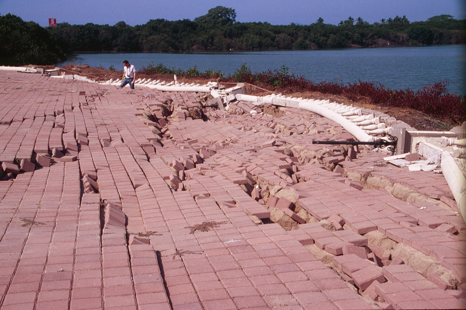
Figure 1.
Lateral spread in fill for causeway between marsh and coastal lagoon in
city of Manzanillo. This lateral spread
is further discussed in the liquefaction section
. |
|
|
|
|
|
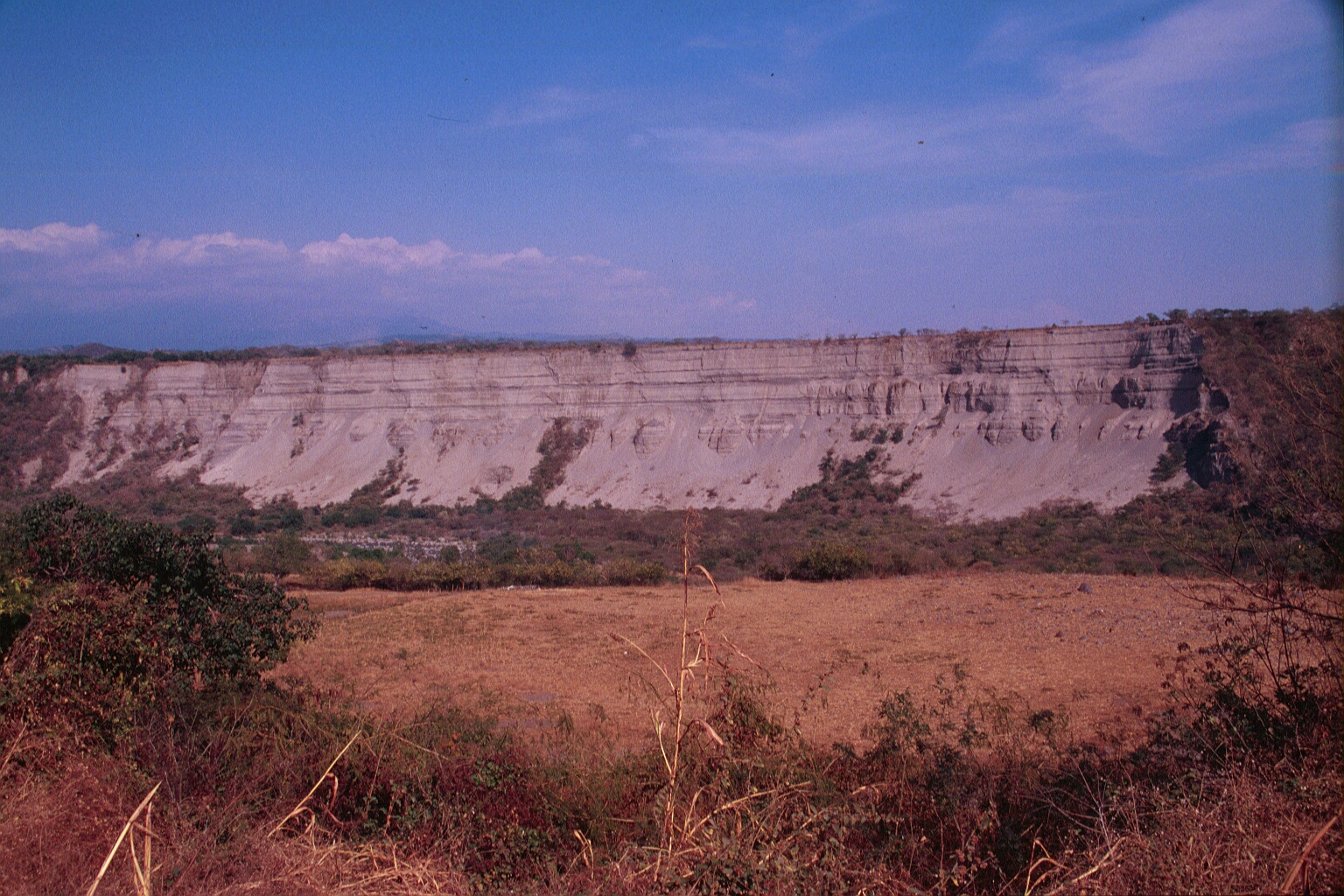
Figure 2.
Stretch of cliff along Rio Armería northwest of Colima denuded by
landslides during the earthquake. Before the earthquake, this stretch
of slope was reportedly vegetated in a manner similar to the unfailed stretch
of slope at the extreme right of the photograph.
Click here to download a 1.5 MB movie of post-earthquake (Jan. 28)
landslides in progress.
|
|
|
Figure 3. One of the larger falls observed from the Rio Armería cliffs on the afternoon of January 28, 2003. A plume of dust accompanied the fall, which had an estimated volume of 20 cubic meters. |
|
|
|
|
|
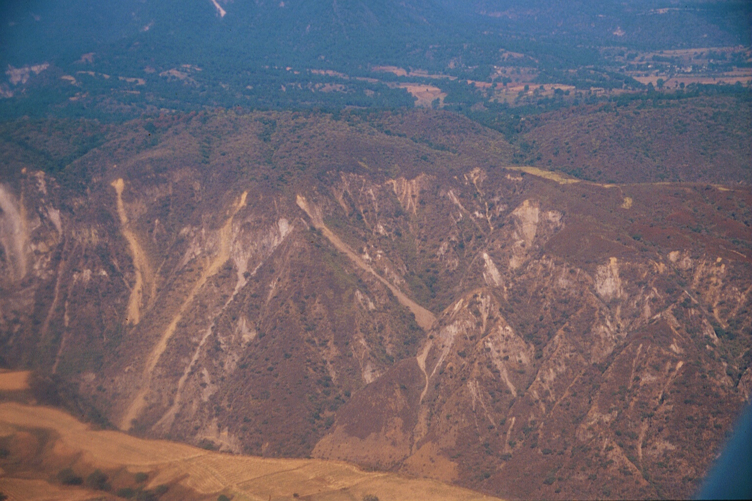
Figure 4.
Landslides along one stretch of canyon wall in the Barranca de Atenquique,
on the east flank of Nevado de Colima volcano. |
|
|
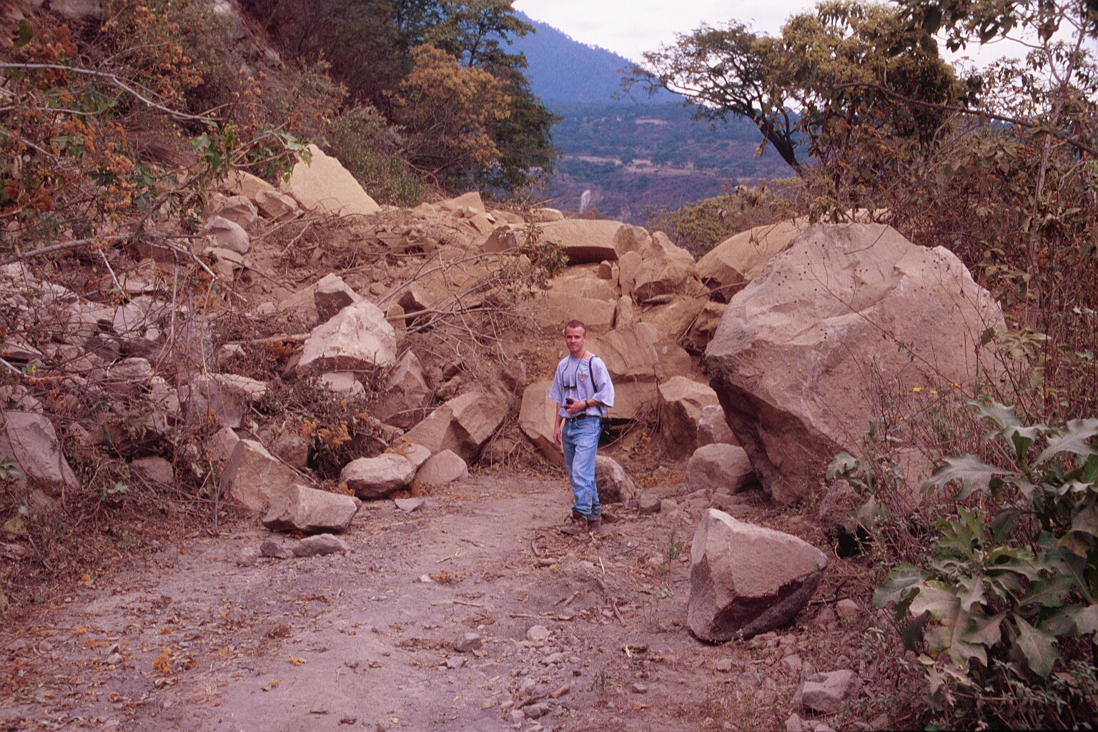
Figure 5.
Part of deposit of rock fall that blocked a secondary road in the Barranca
de Atenquique area. Total volume of rock fall deposit was estimated
at 300 cubic meters. |
|
|
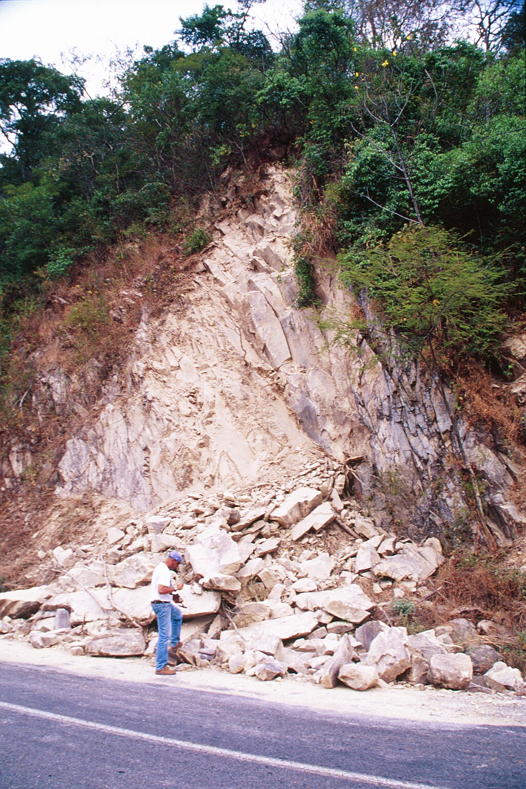
Figure 6.
Rock fall from cut along road between Colima and Minatitlán. |
|
Photographs taken by members
of the geotechnical reconnaissance team
|
|