2017 Hurricane Irma
Event Date :
09-10-2017
Location :
Cape Coral to Key West
Report Date :
10-16-2017
Event Category:
Hurricane
Sequence of Events:
No
Flood Magnitude:
Storm surge reached ~1 m
Storm Magnitude:
Hurricane Category 5
Report Number:
GEER-056
DOI:
doi:10.18118/G6DQ0J
Event Latitude:
24.6642
Event Longitude:
-81.4822
Team:
| Nina Stark |
| Nick Hudyma |
Collaborators:
USACE; City of Key West; Collier County
Contributors:
Nina Stark; Luis Arboleda Monsalve; Inthuorn Sasanakul
Sponsors:
- GEER,
Summary:
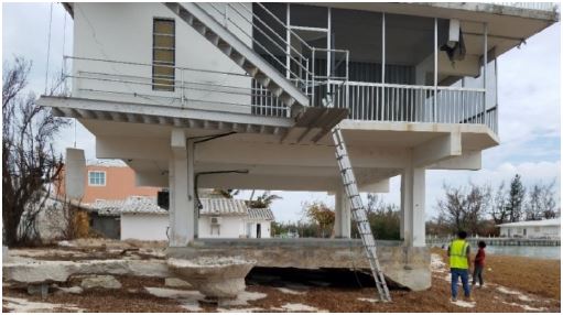
Hurricane Irma was a category 5 hurricane on the Saffir-Simpson hurricane wind scale. Irma made landfall in the U.S. on Cudjoe Key (near Big Pine and Summerland Keys) in the morning of September 10, still being a category 4 hurricane, and made a second landfall on Marco Island, south of Naples, on the same day as a category 3 hurricane. Two teams from the Geotechnical Extreme Events Reconnaissance (GEER) Association, supported by the National Science Foundation, were deployed to investigate geotechnical impacts of flooding, storm surge and wave forcing in Florida in response to Hurricane Irma in September of 2017. The teams worked collaboratively with federal, state, and local organizations in Florida. This report presents the field observations of the GEER team made during the field reconnaissance from September 24 to 28, 2017. The survey region extended along the coastal zone from Cape Coral to Key West. This is a preliminary version of the report including a description of field observations and photos, and listings of additional measurements and sampling conducted. No detailed interpretations or conclusions are provided in this report, due to ongoing data analysis and an incomplete collection of detailed background information. Documented geotechnical impacts include beach and shoreline erosion, undermining of infrastructure, scour (also in locations that are usually not submerged), failure of seawalls and piers, and damage to road embankment and pavement. In addition to sediment erosion, overwash deposits also represented a severe issue covering parks, infrastructure and the interior of houses with heights of up to 1 m. The collected data document the extents of erosion and sediment deposition processes and associated damages during an extreme storm (hurricane of category 4) and inundation event. The data may provide assistance for future design and risk assessment.
File Upload :
| File Title | File Version | File Date | File Type |
|---|---|---|---|
| Report Part A - Cape Coral to Key West | Version 1 | 10-16-2017 |
PDF
|
| Report Part B (Reduced Size) - Northeastern Florida | Version 1 | 10-31-2017 |
PDF
|
| Report Part B (Full Size) | Version 1 | 10-31-2017 |
PDF
|
The work of the GEER Association, in general, is based upon work supported in part by the National Science Foundation through the Geotechnical Engineering Program under Grant No. CMMI-1266418. Any opinions, findings, and conclusions or recommendations expressed in this material are those of the authors and do not necessarily reflect the views of the NSF. The GEER Association is made possible by the vision and support of the NSF Geotechnical Engineering Program Directors: Dr. Richard Fragaszy and the late Dr. Cliff Astill. GEER members also donate their time, talent, and resources to collect time-sensitive field observations of the effects of extreme events.