2018 Anchorage Earthquake
Event Date :
11-30-2018
Location :
Alaska, USA
Report Date :
12-31-2018
Event Category:
Earthquake
EQ Magnitude :
M7.0
Report Number:
GEER-059
DOI:
doi:10.18118/G6P07F
Event Latitude:
61.346
Event Longitude:
-149.955
Team:
| Kevin W. Franke |
| Rich D. Koehler |
Collaborators:
Christine Z. Beyzaei; Ashly Cabas; Ian Pierce; Armin Stuedlein; Zhaohui (Joey) Yang
Contributors:
Stephanie Dow; Michael Freeman; Kannon Lee; Gabriel Pierce
Summary:
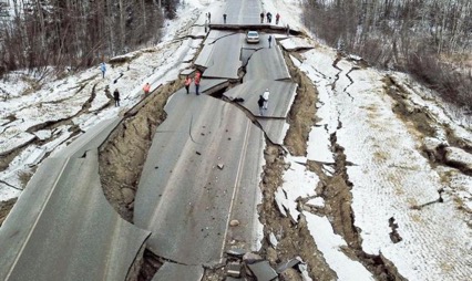
A M7.0 earthquake occurred at 08:29 AM local time on November 30, 2018 approximately 11.3 kilometers north of downtown Anchorage, Alaska (61.346°N, 149.955°W). The instraslab event occurred due to normal faulting within the subducting Pacific plate at an approximate hypocentral depth of 40 kilometers beneath the ground surface. 25 functional ground motion instrument stations recorded the earthquake. Most of these stations showed recorded peak ground accelerations (PGA) between 0.2 g and 0.3 g, with the highest PGA value of 0.474g in the midtown section of Anchorage.
Between the dates of December 8 through 15, 2018, GEER deployed a multi-disciplinary Phase I team comprised of seven investigators to observe and document the significant geotechnical engineering impacts and lessons learned from this event. The GEER team collaborated closely with other engineering reconnaissance efforts including those led by the Earthquake Engineering Research Institute (EERI), the Structural Extreme Events Reconnaissance Association (StEER), the U.S. Geological Survey (USGS), and the Alaska Division of Geological & Geophysical surveys (DGGS). The GEER team also benefited greatly from coordination and partnerships with the local geotechnical engineering community and the Anchorage Geotechnical Advisory Commission (GAC), state department of transportation engineers, Anchorage building officials and engineering service managers, municipal public works officials, and federal agencies including NIST and FEMA. Currently, GEER plans to deploy a Phase II team focused on remote sensing and geophysical data collection in spring 2019 - after the snowmelt.
Based on observations from the GEER team and its collaborators, it appears that the majority of infrastructure damage resulting from this event occurred due to geotechnical issues – principally localized liquefaction in the granular fills beneath structures (particularly beneath residential and small commercial structures in swampy areas), slope instabilities in native slopes and anthropogenic fills, and bearing capacity failures in organic soil deposits due to cyclic softening.
File Upload :
| File Title | File Version | File Date | File Type |
|---|---|---|---|
| Full Report | Version 1 | 03-03-2020 |
PDF
|
| Full Report | Version 2 | 07-10-2019 |
PDF
|
| Full Report | Version 2.1 | 03-11-2020 |
PDF
|
The work of the GEER Association, in general, is based upon work supported in part by the National Science Foundation through the Geotechnical Engineering Program under Grant No. CMMI-1266418. Any opinions, findings, and conclusions or recommendations expressed in this material are those of the authors and do not necessarily reflect the views of the NSF. The GEER Association is made possible by the vision and support of the NSF Geotechnical Engineering Program Directors: Dr. Richard Fragaszy and the late Dr. Cliff Astill. GEER members also donate their time, talent, and resources to collect time-sensitive field observations of the effects of extreme events.