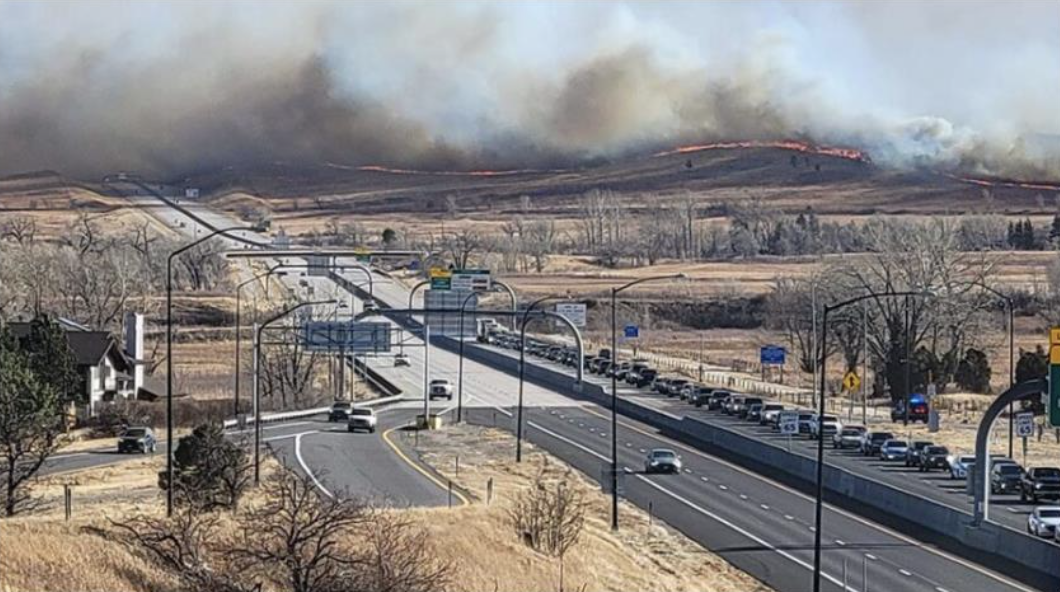
2021 Marshall Wildfire
Event Date :
12-30-2021
Location :
Boulder, CO
Report Date :
06-07-2022
Event Category:
Fire
Fire Acreage:
6200
Report Number:
GEER-075
DOI:
doi:10.18118/G6KT04
Event Latitude:
39.95503
Event Longitude:
-105.15174
Team:
| Erica Fischer (Co-Team Lead) |
| Brad Wham (Co-Team Lead) |
| Shideh Dashti |
| Amy Javernick-Will |
| Abbie Liel |
| Andrew Whelton |
| Nicolas Berty |
| Jacob Klingaman |
| Amy Metz |
| Jessica Ramos |
| Hailey-Rae Rose |
Collaborators:
Louisville Public Works and Utilities and Superior Public Works and Utilities, Corona Environmental Consulting, Ramey Environmental Compliance, Louisville Department of Parks, Recreation, & Open Space, InVision GIS, LLC, Louisville Fire Protection District, West Metro Fire Protection District, East Boulder County, and Maxar Technologies
Contributors:
Audrey Collins, Autumn de la Cruz, Megan Ellery, Jocelyn Gonzalez, Kristofer Isaacson, Caroline Jankowski, Dae Kun Kang, Christian Ley, Jaqueline Zdebski, Karen Dedinsky, Michael Grilliot, Andrew Lyda, and Jamie Vickery, Karen Dedinsky, Jeffrey Berman, and Joseph Wartman
Summary:
The Marshall Fire ignited on December 30th, 2021 and burned over 6200 acres in Boulder County, Colorado in less than 24 hours. The impacted regions included the towns of Louisville, Superior, Lafayette, and unincorporated Boulder County, CO. The Marshall fire destroyed 1091 structures across the region, 97% of which were residential structures. Across the jurisdictions, the total residential damage is estimated to exceed $500 million. In addition to earth retention system, slope, and housing damage, lifeline systems in each jurisdiction were also heavily impacted, including the water distribution systems and treatment plants in Louisville, Superior and unincorporated Boulder County. The evacuation efforts throughout the impacted regions were effective in limiting the death toll to two people.
The GEER team mobilized an interdisciplinary team to investigate the geotechnical, lifelines, and housing impacts of the December 2021 Marshall Fire. The team collected data and observations on the fire impacts to: 1) retaining structures and slopes; 2) lifelines; and 3) housing and structures. In addition, the GEER team investigated the governmental structures in each of the impacted regions and the history of wildfire risk throughout Boulder County. The goal of this version of the GEER report is to summarize the preliminary findings of the team from the collaborative investigation, identify periodically collected uncrewed aerial vehicle (UCAV), LiDAR, and survey data sets available, and establish a basis for future wildfire investigations. The primary field activities conducted by the GEER team occurred from January 24-29, 2022 with follow-on UCAV flights occurring in February and April, 2022
File Upload :
| File Title | File Version | File Date | File Type |
|---|---|---|---|
| Full Report | 1 | 06-07-2022 |
PDF
|
The work of the GEER Association, in general, is based upon work supported in part by the National Science Foundation through the Geotechnical Engineering Program under Grant No. CMMI-1266418. Any opinions, findings, and conclusions or recommendations expressed in this material are those of the authors and do not necessarily reflect the views of the NSF. The GEER Association is made possible by the vision and support of the NSF Geotechnical Engineering Program Directors: Dr. Richard Fragaszy and the late Dr. Cliff Astill. GEER members also donate their time, talent, and resources to collect time-sensitive field observations of the effects of extreme events.